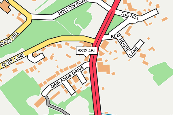
BS32 4BJ is located in the Severn Vale electoral ward, within the unitary authority of South Gloucestershire and the English Parliamentary constituency of Filton and Bradley Stoke. The Sub Integrated Care Board (ICB) Location is NHS Bristol, North Somerset and South Gloucestershire ICB - 15C and the police force is Avon and Somerset. This postcode has been in use since December 1997.


GetTheData
Source: OS OpenMap – Local (Ordnance Survey)
Source: OS VectorMap District (Ordnance Survey)
Licence: Open Government Licence (requires attribution)
| Easting | 360546 |
| Northing | 183789 |
| Latitude | 51.551601 |
| Longitude | -2.570419 |
GetTheData
Source: Open Postcode Geo
Licence: Open Government Licence
| Country | England |
| Postcode District | BS32 |
➜ See where BS32 is on a map ➜ Where is Almondsbury? | |
GetTheData
Source: Land Registry Price Paid Data
Licence: Open Government Licence
Elevation or altitude of BS32 4BJ as distance above sea level:
| Metres | Feet | |
|---|---|---|
| Elevation | 80m | 262ft |
Elevation is measured from the approximate centre of the postcode, to the nearest point on an OS contour line from OS Terrain 50, which has contour spacing of ten vertical metres.
➜ How high above sea level am I? Find the elevation of your current position using your device's GPS.
GetTheData
Source: Open Postcode Elevation
Licence: Open Government Licence
| Ward | Severn Vale |
| Constituency | Filton And Bradley Stoke |
GetTheData
Source: ONS Postcode Database
Licence: Open Government Licence
| Over Lane | Almondsbury | 61m |
| Over Lane | Almondsbury | 81m |
| The Swan (Gloucester Road) | Almondsbury | 124m |
| The Swan | Almondsbury | 141m |
| Almondsbury Depot (Gloucester Road) | Almondsbury | 159m |
| Patchway Station | 2.9km |
| Pilning Station | 4km |
| Bristol Parkway Station | 4.6km |
GetTheData
Source: NaPTAN
Licence: Open Government Licence
GetTheData
Source: ONS Postcode Database
Licence: Open Government Licence


➜ Get more ratings from the Food Standards Agency
GetTheData
Source: Food Standards Agency
Licence: FSA terms & conditions
| Last Collection | |||
|---|---|---|---|
| Location | Mon-Fri | Sat | Distance |
| Weavers Wood | 16:00 | 12:15 | 419m |
| The Village | 16:30 | 11:45 | 422m |
| Florence Park | 16:15 | 12:15 | 688m |
GetTheData
Source: Dracos
Licence: Creative Commons Attribution-ShareAlike
The below table lists the International Territorial Level (ITL) codes (formerly Nomenclature of Territorial Units for Statistics (NUTS) codes) and Local Administrative Units (LAU) codes for BS32 4BJ:
| ITL 1 Code | Name |
|---|---|
| TLK | South West (England) |
| ITL 2 Code | Name |
| TLK1 | Gloucestershire, Wiltshire and Bath/Bristol area |
| ITL 3 Code | Name |
| TLK12 | Bath and North East Somerset, North Somerset and South Gloucestershire |
| LAU 1 Code | Name |
| E06000025 | South Gloucestershire |
GetTheData
Source: ONS Postcode Directory
Licence: Open Government Licence
The below table lists the Census Output Area (OA), Lower Layer Super Output Area (LSOA), and Middle Layer Super Output Area (MSOA) for BS32 4BJ:
| Code | Name | |
|---|---|---|
| OA | E00075095 | |
| LSOA | E01014862 | South Gloucestershire 005B |
| MSOA | E02003094 | South Gloucestershire 005 |
GetTheData
Source: ONS Postcode Directory
Licence: Open Government Licence
| BS32 4AB | Oaklands Drive | 101m |
| BS32 4BL | Over Lane | 166m |
| BS32 4AE | The Hill | 186m |
| BS32 4BB | Red House Lane | 193m |
| BS32 4DP | Hollow Road | 221m |
| BS32 4AD | Gloucester Road | 256m |
| BS32 4DS | Sundays Hill | 305m |
| BS32 4DL | Glebe Field | 333m |
| BS32 4AG | Gloucester Road | 338m |
| BS32 4DT | Church Road | 385m |
GetTheData
Source: Open Postcode Geo; Land Registry Price Paid Data
Licence: Open Government Licence