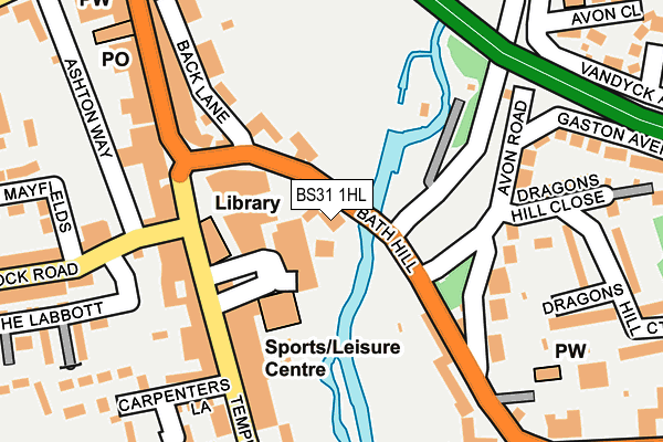
BS31 1HL is located in the Keynsham North electoral ward, within the unitary authority of Bath and North East Somerset and the English Parliamentary constituency of North East Somerset. The Sub Integrated Care Board (ICB) Location is NHS Bath and North East Somerset, Swindon and Wiltshire ICB - 92 and the police force is Avon and Somerset. This postcode has been in use since December 1997.


GetTheData
Source: OS OpenMap – Local (Ordnance Survey)
Source: OS VectorMap District (Ordnance Survey)
Licence: Open Government Licence (requires attribution)
| Easting | 365602 |
| Northing | 168456 |
| Latitude | 51.414071 |
| Longitude | -2.496004 |
GetTheData
Source: Open Postcode Geo
Licence: Open Government Licence
| Country | England |
| Postcode District | BS31 |
➜ See where BS31 is on a map ➜ Where is Keynsham? | |
GetTheData
Source: Land Registry Price Paid Data
Licence: Open Government Licence
Elevation or altitude of BS31 1HL as distance above sea level:
| Metres | Feet | |
|---|---|---|
| Elevation | 20m | 66ft |
Elevation is measured from the approximate centre of the postcode, to the nearest point on an OS contour line from OS Terrain 50, which has contour spacing of ten vertical metres.
➜ How high above sea level am I? Find the elevation of your current position using your device's GPS.
GetTheData
Source: Open Postcode Elevation
Licence: Open Government Licence
| Ward | Keynsham North |
| Constituency | North East Somerset |
GetTheData
Source: ONS Postcode Database
Licence: Open Government Licence
| Keynsham Memorial Park (Bath Hill) | Keynsham | 31m |
| Temple Street | Keynsham | 162m |
| Ashton Way | Keynsham | 209m |
| Wellsway | Keynsham | 250m |
| Post Office (High Street) | Keynsham | 257m |
| Keynsham Station | 0.4km |
| Lawrence Hill Station | 6.8km |
GetTheData
Source: NaPTAN
Licence: Open Government Licence
GetTheData
Source: ONS Postcode Database
Licence: Open Government Licence


➜ Get more ratings from the Food Standards Agency
GetTheData
Source: Food Standards Agency
Licence: FSA terms & conditions
| Last Collection | |||
|---|---|---|---|
| Location | Mon-Fri | Sat | Distance |
| Keynsham Post Office | 18:00 | 12:00 | 259m |
| Westview Road | 17:30 | 12:15 | 430m |
| Station Road | 17:30 | 12:30 | 475m |
GetTheData
Source: Dracos
Licence: Creative Commons Attribution-ShareAlike
The below table lists the International Territorial Level (ITL) codes (formerly Nomenclature of Territorial Units for Statistics (NUTS) codes) and Local Administrative Units (LAU) codes for BS31 1HL:
| ITL 1 Code | Name |
|---|---|
| TLK | South West (England) |
| ITL 2 Code | Name |
| TLK1 | Gloucestershire, Wiltshire and Bath/Bristol area |
| ITL 3 Code | Name |
| TLK12 | Bath and North East Somerset, North Somerset and South Gloucestershire |
| LAU 1 Code | Name |
| E06000022 | Bath and North East Somerset |
GetTheData
Source: ONS Postcode Directory
Licence: Open Government Licence
The below table lists the Census Output Area (OA), Lower Layer Super Output Area (LSOA), and Middle Layer Super Output Area (MSOA) for BS31 1HL:
| Code | Name | |
|---|---|---|
| OA | E00072745 | |
| LSOA | E01014403 | Bath and North East Somerset 002B |
| MSOA | E02002986 | Bath and North East Somerset 002 |
GetTheData
Source: ONS Postcode Directory
Licence: Open Government Licence
| BS31 1HG | Bath Hill | 32m |
| BS31 1HE | River Terrace | 86m |
| BS31 1ET | Back Lane | 143m |
| BS31 1EG | Temple Street | 147m |
| BS31 1HH | Bath Hill | 147m |
| BS31 1EH | Temple Street | 150m |
| BS31 1LJ | Avon Road | 156m |
| BS31 1HQ | Bath Hill | 161m |
| BS31 1HB | Temple Street | 183m |
| BS31 1LP | Avon Road | 188m |
GetTheData
Source: Open Postcode Geo; Land Registry Price Paid Data
Licence: Open Government Licence