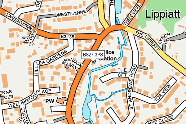
BS27 3PS is located in the Cheddar electoral ward, within the unitary authority of Somerset and the English Parliamentary constituency of Wells. The Sub Integrated Care Board (ICB) Location is NHS Somerset ICB - 11X and the police force is Avon and Somerset. This postcode has been in use since January 1980.


GetTheData
Source: OS OpenMap – Local (Ordnance Survey)
Source: OS VectorMap District (Ordnance Survey)
Licence: Open Government Licence (requires attribution)
| Easting | 346079 |
| Northing | 153560 |
| Latitude | 51.278614 |
| Longitude | -2.774449 |
GetTheData
Source: Open Postcode Geo
Licence: Open Government Licence
| Country | England |
| Postcode District | BS27 |
➜ See where BS27 is on a map ➜ Where is Cheddar? | |
GetTheData
Source: Land Registry Price Paid Data
Licence: Open Government Licence
Elevation or altitude of BS27 3PS as distance above sea level:
| Metres | Feet | |
|---|---|---|
| Elevation | 20m | 66ft |
Elevation is measured from the approximate centre of the postcode, to the nearest point on an OS contour line from OS Terrain 50, which has contour spacing of ten vertical metres.
➜ How high above sea level am I? Find the elevation of your current position using your device's GPS.
GetTheData
Source: Open Postcode Elevation
Licence: Open Government Licence
| Ward | Cheddar |
| Constituency | Wells |
GetTheData
Source: ONS Postcode Database
Licence: Open Government Licence
1, OLD STATION MEWS, CHEDDAR, BS27 3PS 2020 11 NOV £380,000 |
GetTheData
Source: HM Land Registry Price Paid Data
Licence: Contains HM Land Registry data © Crown copyright and database right 2025. This data is licensed under the Open Government Licence v3.0.
| Tweentown | Cheddar | 79m |
| Tweentown | Cheddar | 92m |
| Greenhill House (Tweentown) | Cheddar | 355m |
| Greenhill House (Tweentown) | Cheddar | 369m |
| Union Street | Cheddar | 392m |
GetTheData
Source: NaPTAN
Licence: Open Government Licence
GetTheData
Source: ONS Postcode Database
Licence: Open Government Licence


➜ Get more ratings from the Food Standards Agency
GetTheData
Source: Food Standards Agency
Licence: FSA terms & conditions
| Last Collection | |||
|---|---|---|---|
| Location | Mon-Fri | Sat | Distance |
| Lippiatt | 16:30 | 08:45 | 128m |
| Cheddar Post Office | 17:15 | 12:00 | 439m |
| Tweentown | 16:30 | 09:15 | 463m |
GetTheData
Source: Dracos
Licence: Creative Commons Attribution-ShareAlike
| Risk of BS27 3PS flooding from rivers and sea | Medium |
| ➜ BS27 3PS flood map | |
GetTheData
Source: Open Flood Risk by Postcode
Licence: Open Government Licence
The below table lists the International Territorial Level (ITL) codes (formerly Nomenclature of Territorial Units for Statistics (NUTS) codes) and Local Administrative Units (LAU) codes for BS27 3PS:
| ITL 1 Code | Name |
|---|---|
| TLK | South West (England) |
| ITL 2 Code | Name |
| TLK2 | Dorset and Somerset |
| ITL 3 Code | Name |
| TLK23 | Somerset CC |
| LAU 1 Code | Name |
| E07000188 | Sedgemoor |
GetTheData
Source: ONS Postcode Directory
Licence: Open Government Licence
The below table lists the Census Output Area (OA), Lower Layer Super Output Area (LSOA), and Middle Layer Super Output Area (MSOA) for BS27 3PS:
| Code | Name | |
|---|---|---|
| OA | E00148363 | |
| LSOA | E01029126 | Sedgemoor 001B |
| MSOA | E02006061 | Sedgemoor 001 |
GetTheData
Source: ONS Postcode Directory
Licence: Open Government Licence
| BS27 3PT | Cliff Street | 35m |
| BS27 3PR | Montrose Villas | 40m |
| BS27 3PU | Brendon Way | 66m |
| BS27 3NH | The Croft | 88m |
| BS27 3JF | Tweentown | 111m |
| BS27 3JJ | Birch Hill | 118m |
| BS27 3PX | Cliff Street | 120m |
| BS27 3JH | Hill Lea Gardens | 126m |
| BS27 3NG | St Andrews Road | 160m |
| BS27 3NF | Woodview Road | 164m |
GetTheData
Source: Open Postcode Geo; Land Registry Price Paid Data
Licence: Open Government Licence