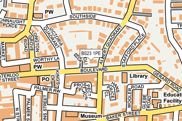
BS23 1PE lies on Boulevard in Weston-super-mare. BS23 1PE is located in the Weston-super-Mare Hillside electoral ward, within the unitary authority of North Somerset and the English Parliamentary constituency of Weston-Super-Mare. The Sub Integrated Care Board (ICB) Location is NHS Bristol, North Somerset and South Gloucestershire ICB - 15C and the police force is Avon and Somerset. This postcode has been in use since January 1980.


GetTheData
Source: OS OpenMap – Local (Ordnance Survey)
Source: OS VectorMap District (Ordnance Survey)
Licence: Open Government Licence (requires attribution)
| Easting | 332245 |
| Northing | 161730 |
| Latitude | 51.350590 |
| Longitude | -2.974308 |
GetTheData
Source: Open Postcode Geo
Licence: Open Government Licence
| Street | Boulevard |
| Town/City | Weston-super-mare |
| Country | England |
| Postcode District | BS23 |
➜ See where BS23 is on a map ➜ Where is Weston-Super-Mare? | |
GetTheData
Source: Land Registry Price Paid Data
Licence: Open Government Licence
Elevation or altitude of BS23 1PE as distance above sea level:
| Metres | Feet | |
|---|---|---|
| Elevation | 10m | 33ft |
Elevation is measured from the approximate centre of the postcode, to the nearest point on an OS contour line from OS Terrain 50, which has contour spacing of ten vertical metres.
➜ How high above sea level am I? Find the elevation of your current position using your device's GPS.
GetTheData
Source: Open Postcode Elevation
Licence: Open Government Licence
| Ward | Weston-super-mare Hillside |
| Constituency | Weston-super-mare |
GetTheData
Source: ONS Postcode Database
Licence: Open Government Licence
| Albert Quadrant | Weston-super-mare | 30m |
| Boulevard | Grove Park | 35m |
| Boulevard | Grove Park | 37m |
| Alfred Street | Weston-super-mare | 76m |
| Stafford Place | Ashcombe Park | 222m |
| Weston-super-Mare Station | 0.7km |
| Weston Milton Station | 2.2km |
| Worle Station | 4.6km |
GetTheData
Source: NaPTAN
Licence: Open Government Licence
GetTheData
Source: ONS Postcode Database
Licence: Open Government Licence


➜ Get more ratings from the Food Standards Agency
GetTheData
Source: Food Standards Agency
Licence: FSA terms & conditions
| Last Collection | |||
|---|---|---|---|
| Location | Mon-Fri | Sat | Distance |
| Public Library | 18:30 | 12:15 | 137m |
| The Boulevard Post Office | 18:30 | 12:30 | 183m |
| Regent Street Post Office | 18:30 | 13:00 | 420m |
GetTheData
Source: Dracos
Licence: Creative Commons Attribution-ShareAlike
| Risk of BS23 1PE flooding from rivers and sea | Medium |
| ➜ BS23 1PE flood map | |
GetTheData
Source: Open Flood Risk by Postcode
Licence: Open Government Licence
The below table lists the International Territorial Level (ITL) codes (formerly Nomenclature of Territorial Units for Statistics (NUTS) codes) and Local Administrative Units (LAU) codes for BS23 1PE:
| ITL 1 Code | Name |
|---|---|
| TLK | South West (England) |
| ITL 2 Code | Name |
| TLK1 | Gloucestershire, Wiltshire and Bath/Bristol area |
| ITL 3 Code | Name |
| TLK12 | Bath and North East Somerset, North Somerset and South Gloucestershire |
| LAU 1 Code | Name |
| E06000024 | North Somerset |
GetTheData
Source: ONS Postcode Directory
Licence: Open Government Licence
The below table lists the Census Output Area (OA), Lower Layer Super Output Area (LSOA), and Middle Layer Super Output Area (MSOA) for BS23 1PE:
| Code | Name | |
|---|---|---|
| OA | E00075003 | |
| LSOA | E01014844 | North Somerset 018D |
| MSOA | E02003082 | North Somerset 018 |
GetTheData
Source: ONS Postcode Directory
Licence: Open Government Licence
| BS23 1PD | Boulevard | 29m |
| BS23 1NF | Boulevard | 51m |
| BS23 2QY | Albert Quadrant | 74m |
| BS23 1NZ | Boulevard | 78m |
| BS23 1RW | Prospect Place | 93m |
| BS23 1NR | Boulevard | 122m |
| BS23 2QX | Southside | 123m |
| BS23 1PT | Meadow Villas | 125m |
| BS23 1RL | Orchard Street | 134m |
| BS23 1RN | Meadow Villas | 135m |
GetTheData
Source: Open Postcode Geo; Land Registry Price Paid Data
Licence: Open Government Licence