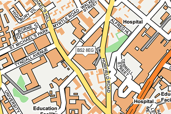
BS2 8EG is located in the Central electoral ward, within the unitary authority of Bristol, City of and the English Parliamentary constituency of Bristol West. The Sub Integrated Care Board (ICB) Location is NHS Bristol, North Somerset and South Gloucestershire ICB - 15C and the police force is Avon and Somerset. This postcode has been in use since January 1980.


GetTheData
Source: OS OpenMap – Local (Ordnance Survey)
Source: OS VectorMap District (Ordnance Survey)
Licence: Open Government Licence (requires attribution)
| Easting | 358453 |
| Northing | 173521 |
| Latitude | 51.459131 |
| Longitude | -2.599391 |
GetTheData
Source: Open Postcode Geo
Licence: Open Government Licence
| Country | England |
| Postcode District | BS2 |
➜ See where BS2 is on a map ➜ Where is Bristol? | |
GetTheData
Source: Land Registry Price Paid Data
Licence: Open Government Licence
Elevation or altitude of BS2 8EG as distance above sea level:
| Metres | Feet | |
|---|---|---|
| Elevation | 60m | 197ft |
Elevation is measured from the approximate centre of the postcode, to the nearest point on an OS contour line from OS Terrain 50, which has contour spacing of ten vertical metres.
➜ How high above sea level am I? Find the elevation of your current position using your device's GPS.
GetTheData
Source: Open Postcode Elevation
Licence: Open Government Licence
| Ward | Central |
| Constituency | Bristol West |
GetTheData
Source: ONS Postcode Database
Licence: Open Government Licence
| Myrtle Road (Saint Michael's Hill) | Kingsdown | 138m |
| Horfield Road | Kingsdown | 149m |
| Horfield Road | Kingsdown | 166m |
| Myrtle Road (Saint Michael's Hill) | Kingsdown | 198m |
| Kingsdown Parade (Montague Place) | Kingsdown | 229m |
| Redland Station | 1km |
| Clifton Down Station | 1km |
| Montpelier Station | 1.3km |
GetTheData
Source: NaPTAN
Licence: Open Government Licence
GetTheData
Source: ONS Postcode Database
Licence: Open Government Licence


➜ Get more ratings from the Food Standards Agency
GetTheData
Source: Food Standards Agency
Licence: FSA terms & conditions
| Last Collection | |||
|---|---|---|---|
| Location | Mon-Fri | Sat | Distance |
| St Michaels Hill | 16:45 | 11:30 | 67m |
| Horfield Road | 17:45 | 12:30 | 107m |
| Bristol Royal Infirmary | 17:45 | 12:45 | 212m |
GetTheData
Source: Dracos
Licence: Creative Commons Attribution-ShareAlike
The below table lists the International Territorial Level (ITL) codes (formerly Nomenclature of Territorial Units for Statistics (NUTS) codes) and Local Administrative Units (LAU) codes for BS2 8EG:
| ITL 1 Code | Name |
|---|---|
| TLK | South West (England) |
| ITL 2 Code | Name |
| TLK1 | Gloucestershire, Wiltshire and Bath/Bristol area |
| ITL 3 Code | Name |
| TLK11 | Bristol, City of |
| LAU 1 Code | Name |
| E06000023 | Bristol, City of |
GetTheData
Source: ONS Postcode Directory
Licence: Open Government Licence
The below table lists the Census Output Area (OA), Lower Layer Super Output Area (LSOA), and Middle Layer Super Output Area (MSOA) for BS2 8EG:
| Code | Name | |
|---|---|---|
| OA | E00174312 | |
| LSOA | E01014542 | Bristol 032C |
| MSOA | E02003043 | Bristol 032 |
GetTheData
Source: ONS Postcode Directory
Licence: Open Government Licence
| BS2 8DS | Robin Hood Lane | 60m |
| BS2 8BQ | St Michaels Hill | 99m |
| BS2 8EJ | Southwell Street | 100m |
| BS2 8EQ | Horfield Road | 103m |
| BS2 8DX | St Michaels Hill | 119m |
| BS2 8EH | Prospect Avenue | 123m |
| BS2 8DZ | St Michaels Hill | 130m |
| BS2 8BL | Myrtle Road | 161m |
| BS2 8BU | St Michaels Hill | 166m |
| BS2 8HN | Alfred Hill | 177m |
GetTheData
Source: Open Postcode Geo; Land Registry Price Paid Data
Licence: Open Government Licence