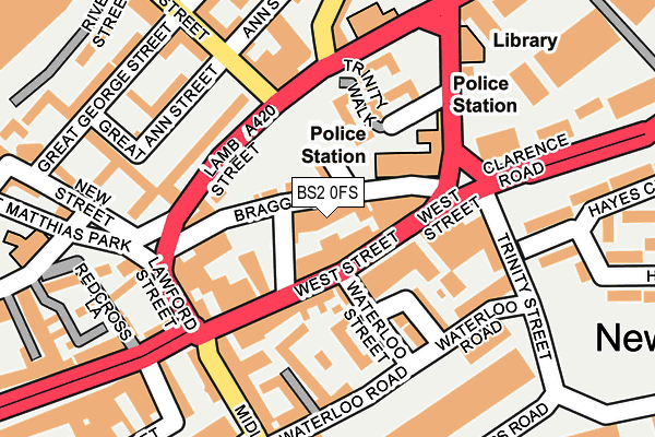
BS2 0FS is located in the Lawrence Hill electoral ward, within the unitary authority of Bristol, City of and the English Parliamentary constituency of Bristol West. The Sub Integrated Care Board (ICB) Location is NHS Bristol, North Somerset and South Gloucestershire ICB - 15C and the police force is Avon and Somerset. This postcode has been in use since June 2017.


GetTheData
Source: OS OpenMap – Local (Ordnance Survey)
Source: OS VectorMap District (Ordnance Survey)
Licence: Open Government Licence (requires attribution)
| Easting | 359923 |
| Northing | 173320 |
| Latitude | 51.457428 |
| Longitude | -2.578212 |
GetTheData
Source: Open Postcode Geo
Licence: Open Government Licence
| Country | England |
| Postcode District | BS2 |
➜ See where BS2 is on a map ➜ Where is Bristol? | |
GetTheData
Source: Land Registry Price Paid Data
Licence: Open Government Licence
| Ward | Lawrence Hill |
| Constituency | Bristol West |
GetTheData
Source: ONS Postcode Database
Licence: Open Government Licence
| West Street | Old Market | 56m |
| Lamb Street | Old Market | 117m |
| Thrissell Street (Stapleton Road) | Easton | 266m |
| Old Market Street | Old Market | 276m |
| Old Market Street | Old Market | 320m |
| Bristol Temple Meads Station | 0.9km |
| Lawrence Hill Station | 1km |
| Stapleton Road Station | 1.4km |
GetTheData
Source: NaPTAN
Licence: Open Government Licence
| Percentage of properties with Next Generation Access | 0.0% |
| Percentage of properties with Superfast Broadband | 0.0% |
| Percentage of properties with Ultrafast Broadband | 0.0% |
| Percentage of properties with Full Fibre Broadband | 0.0% |
Superfast Broadband is between 30Mbps and 300Mbps
Ultrafast Broadband is > 300Mbps
| Median download speed | 21.8Mbps |
| Average download speed | 21.4Mbps |
| Maximum download speed | 23.41Mbps |
| Median upload speed | 1.2Mbps |
| Average upload speed | 1.2Mbps |
| Maximum upload speed | 1.27Mbps |
| Percentage of properties unable to receive 2Mbps | 0.0% |
| Percentage of properties unable to receive 5Mbps | 0.0% |
| Percentage of properties unable to receive 10Mbps | 0.0% |
| Percentage of properties unable to receive 30Mbps | 100.0% |
GetTheData
Source: Ofcom
Licence: Ofcom Terms of Use (requires attribution)
GetTheData
Source: ONS Postcode Database
Licence: Open Government Licence


➜ Get more ratings from the Food Standards Agency
GetTheData
Source: Food Standards Agency
Licence: FSA terms & conditions
| Last Collection | |||
|---|---|---|---|
| Location | Mon-Fri | Sat | Distance |
| Wade Street | 17:00 | 11:30 | 125m |
| Trinity Street | 17:00 | 12:15 | 163m |
| Midland Road Post Office | 18:00 | 11:45 | 223m |
GetTheData
Source: Dracos
Licence: Creative Commons Attribution-ShareAlike
The below table lists the International Territorial Level (ITL) codes (formerly Nomenclature of Territorial Units for Statistics (NUTS) codes) and Local Administrative Units (LAU) codes for BS2 0FS:
| ITL 1 Code | Name |
|---|---|
| TLK | South West (England) |
| ITL 2 Code | Name |
| TLK1 | Gloucestershire, Wiltshire and Bath/Bristol area |
| ITL 3 Code | Name |
| TLK11 | Bristol, City of |
| LAU 1 Code | Name |
| E06000023 | Bristol, City of |
GetTheData
Source: ONS Postcode Directory
Licence: Open Government Licence
The below table lists the Census Output Area (OA), Lower Layer Super Output Area (LSOA), and Middle Layer Super Output Area (MSOA) for BS2 0FS:
| Code | Name | |
|---|---|---|
| OA | E00174282 | |
| LSOA | E01033358 | Bristol 054D |
| MSOA | E02006887 | Bristol 054 |
GetTheData
Source: ONS Postcode Directory
Licence: Open Government Licence
| BS2 0FJ | Braggs Lane | 30m |
| BS2 0AX | Braggs Lane | 33m |
| BS2 0BZ | West Street | 34m |
| BS2 0EB | Braggs Lane | 47m |
| BS2 0DP | Gloucester Lane | 52m |
| BS2 0BX | West Street | 65m |
| BS2 0BL | West Street | 75m |
| BS2 0BP | West Street | 95m |
| BS2 0BW | West Street | 95m |
| BS2 0BH | West Street | 98m |
GetTheData
Source: Open Postcode Geo; Land Registry Price Paid Data
Licence: Open Government Licence