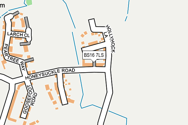
BS16 7LS is located in the Emersons Green electoral ward, within the unitary authority of South Gloucestershire and the English Parliamentary constituency of Thornbury and Yate. The Sub Integrated Care Board (ICB) Location is NHS Bristol, North Somerset and South Gloucestershire ICB - 15C and the police force is Avon and Somerset. This postcode has been in use since July 2017.


GetTheData
Source: OS OpenMap – Local (Ordnance Survey)
Source: OS VectorMap District (Ordnance Survey)
Licence: Open Government Licence (requires attribution)
| Easting | 367933 |
| Northing | 177501 |
| Latitude | 51.495533 |
| Longitude | -2.463310 |
GetTheData
Source: Open Postcode Geo
Licence: Open Government Licence
| Country | England |
| Postcode District | BS16 |
➜ See where BS16 is on a map ➜ Where is Mangotsfield? | |
GetTheData
Source: Land Registry Price Paid Data
Licence: Open Government Licence
| Ward | Emersons Green |
| Constituency | Thornbury And Yate |
GetTheData
Source: ONS Postcode Database
Licence: Open Government Licence
| Lyde Green | Emersons Green | 329m |
| Lyde Green | Emersons Green | 387m |
| Sainsburys | Emersons Green | 774m |
| Church Farm Road (Emerson Way) | Emersons Green | 871m |
| Church Farm Road (Emerson Way) | Emersons Green | 883m |
| Yate Station | 5.4km |
GetTheData
Source: NaPTAN
Licence: Open Government Licence
| Percentage of properties with Next Generation Access | 100.0% |
| Percentage of properties with Superfast Broadband | 100.0% |
| Percentage of properties with Ultrafast Broadband | 100.0% |
| Percentage of properties with Full Fibre Broadband | 100.0% |
Superfast Broadband is between 30Mbps and 300Mbps
Ultrafast Broadband is > 300Mbps
| Percentage of properties unable to receive 2Mbps | 0.0% |
| Percentage of properties unable to receive 5Mbps | 0.0% |
| Percentage of properties unable to receive 10Mbps | 0.0% |
| Percentage of properties unable to receive 30Mbps | 0.0% |
GetTheData
Source: Ofcom
Licence: Ofcom Terms of Use (requires attribution)
GetTheData
Source: ONS Postcode Database
Licence: Open Government Licence


➜ Get more ratings from the Food Standards Agency
GetTheData
Source: Food Standards Agency
Licence: FSA terms & conditions
| Last Collection | |||
|---|---|---|---|
| Location | Mon-Fri | Sat | Distance |
| Emersons Green Post Office | 17:00 | 11:45 | 904m |
| Vinney Green | 17:15 | 09:30 | 1,304m |
| Shortwood | 16:45 | 10:30 | 1,467m |
GetTheData
Source: Dracos
Licence: Creative Commons Attribution-ShareAlike
The below table lists the International Territorial Level (ITL) codes (formerly Nomenclature of Territorial Units for Statistics (NUTS) codes) and Local Administrative Units (LAU) codes for BS16 7LS:
| ITL 1 Code | Name |
|---|---|
| TLK | South West (England) |
| ITL 2 Code | Name |
| TLK1 | Gloucestershire, Wiltshire and Bath/Bristol area |
| ITL 3 Code | Name |
| TLK12 | Bath and North East Somerset, North Somerset and South Gloucestershire |
| LAU 1 Code | Name |
| E06000025 | South Gloucestershire |
GetTheData
Source: ONS Postcode Directory
Licence: Open Government Licence
The below table lists the Census Output Area (OA), Lower Layer Super Output Area (LSOA), and Middle Layer Super Output Area (MSOA) for BS16 7LS:
| Code | Name | |
|---|---|---|
| OA | E00075130 | |
| LSOA | E01014868 | South Gloucestershire 019B |
| MSOA | E02003108 | South Gloucestershire 019 |
GetTheData
Source: ONS Postcode Directory
Licence: Open Government Licence
| BS16 7FZ | Larch Close | 258m |
| BS16 7FY | Pear Tree Way | 301m |
| BS16 7GB | Willowherb Road | 383m |
| BS16 7GG | Pennycress Close | 402m |
| BS16 7GF | Clover Road | 431m |
| BS16 7FP | Willowherb Road | 532m |
| BS16 7GZ | Rowan Drive | 538m |
| BS16 7FU | Acorn Drive | 551m |
| BS16 7NT | 571m | |
| BS16 9NN | Cattybrook Road North | 585m |
GetTheData
Source: Open Postcode Geo; Land Registry Price Paid Data
Licence: Open Government Licence