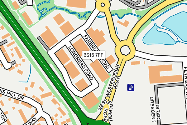
BS16 7FF is located in the Emersons Green electoral ward, within the unitary authority of South Gloucestershire and the English Parliamentary constituency of Kingswood. The Sub Integrated Care Board (ICB) Location is NHS Bristol, North Somerset and South Gloucestershire ICB - 15C and the police force is Avon and Somerset. This postcode has been in use since June 2000.


GetTheData
Source: OS OpenMap – Local (Ordnance Survey)
Source: OS VectorMap District (Ordnance Survey)
Licence: Open Government Licence (requires attribution)
| Easting | 366742 |
| Northing | 178148 |
| Latitude | 51.501282 |
| Longitude | -2.480527 |
GetTheData
Source: Open Postcode Geo
Licence: Open Government Licence
| Country | England |
| Postcode District | BS16 |
➜ See where BS16 is on a map ➜ Where is Mangotsfield? | |
GetTheData
Source: Land Registry Price Paid Data
Licence: Open Government Licence
Elevation or altitude of BS16 7FF as distance above sea level:
| Metres | Feet | |
|---|---|---|
| Elevation | 50m | 164ft |
Elevation is measured from the approximate centre of the postcode, to the nearest point on an OS contour line from OS Terrain 50, which has contour spacing of ten vertical metres.
➜ How high above sea level am I? Find the elevation of your current position using your device's GPS.
GetTheData
Source: Open Postcode Elevation
Licence: Open Government Licence
| Ward | Emersons Green |
| Constituency | Kingswood |
GetTheData
Source: ONS Postcode Database
Licence: Open Government Licence
| Folly Brook Road | Blackhorse | 72m |
| Folly Brook Road | Blackhorse | 90m |
| Science Park | Emersons Green | 305m |
| Science Park | Emersons Green | 317m |
| Treatment Centre (The Brooms) | Blackhorse | 331m |
| Bristol Parkway Station | 4.5km |
| Yate Station | 5.5km |
GetTheData
Source: NaPTAN
Licence: Open Government Licence
GetTheData
Source: ONS Postcode Database
Licence: Open Government Licence


➜ Get more ratings from the Food Standards Agency
GetTheData
Source: Food Standards Agency
Licence: FSA terms & conditions
| Last Collection | |||
|---|---|---|---|
| Location | Mon-Fri | Sat | Distance |
| Black Horse | 17:30 | 12:15 | 565m |
| The Trident | 17:30 | 12:15 | 809m |
| Blackhorse Old Post Office | 17:30 | 12:00 | 822m |
GetTheData
Source: Dracos
Licence: Creative Commons Attribution-ShareAlike
The below table lists the International Territorial Level (ITL) codes (formerly Nomenclature of Territorial Units for Statistics (NUTS) codes) and Local Administrative Units (LAU) codes for BS16 7FF:
| ITL 1 Code | Name |
|---|---|
| TLK | South West (England) |
| ITL 2 Code | Name |
| TLK1 | Gloucestershire, Wiltshire and Bath/Bristol area |
| ITL 3 Code | Name |
| TLK12 | Bath and North East Somerset, North Somerset and South Gloucestershire |
| LAU 1 Code | Name |
| E06000025 | South Gloucestershire |
GetTheData
Source: ONS Postcode Directory
Licence: Open Government Licence
The below table lists the Census Output Area (OA), Lower Layer Super Output Area (LSOA), and Middle Layer Super Output Area (MSOA) for BS16 7FF:
| Code | Name | |
|---|---|---|
| OA | E00075611 | |
| LSOA | E01014966 | South Gloucestershire 021B |
| MSOA | E02003110 | South Gloucestershire 021 |
GetTheData
Source: ONS Postcode Directory
Licence: Open Government Licence
| BS16 7FR | Dirac Crescent | 210m |
| BS16 7DN | Westons Hill Drive | 249m |
| BS16 7DQ | Bye Mead | 286m |
| BS16 7BT | Cynder Way | 303m |
| BS16 7DJ | Salmons Way | 327m |
| BS16 7FH | The Brooms | 349m |
| BS16 7DH | Patch Court | 355m |
| BS16 7DF | Westons Hill Drive | 367m |
| BS16 7DL | Bye Mead | 383m |
| BS16 7BP | Westons Brake | 420m |
GetTheData
Source: Open Postcode Geo; Land Registry Price Paid Data
Licence: Open Government Licence