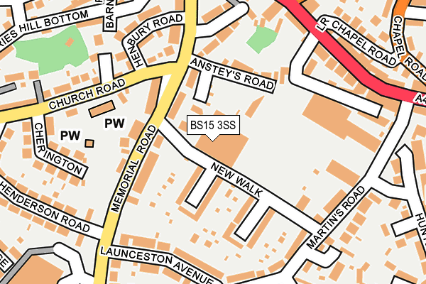
BS15 3SS is located in the Hanham electoral ward, within the unitary authority of South Gloucestershire and the English Parliamentary constituency of Kingswood. The Sub Integrated Care Board (ICB) Location is NHS Bristol, North Somerset and South Gloucestershire ICB - 15C and the police force is Avon and Somerset. This postcode has been in use since June 1996.


GetTheData
Source: OS OpenMap – Local (Ordnance Survey)
Source: OS VectorMap District (Ordnance Survey)
Licence: Open Government Licence (requires attribution)
| Easting | 363970 |
| Northing | 172259 |
| Latitude | 51.448161 |
| Longitude | -2.519858 |
GetTheData
Source: Open Postcode Geo
Licence: Open Government Licence
| Country | England |
| Postcode District | BS15 |
➜ See where BS15 is on a map ➜ Where is Kingswood? | |
GetTheData
Source: Land Registry Price Paid Data
Licence: Open Government Licence
Elevation or altitude of BS15 3SS as distance above sea level:
| Metres | Feet | |
|---|---|---|
| Elevation | 60m | 197ft |
Elevation is measured from the approximate centre of the postcode, to the nearest point on an OS contour line from OS Terrain 50, which has contour spacing of ten vertical metres.
➜ How high above sea level am I? Find the elevation of your current position using your device's GPS.
GetTheData
Source: Open Postcode Elevation
Licence: Open Government Licence
| Ward | Hanham |
| Constituency | Kingswood |
GetTheData
Source: ONS Postcode Database
Licence: Open Government Licence
| Church Road (Memorial Road) | Hanham | 195m |
| Church Road (Memorial Road) | Hanham | 209m |
| The Maypole (High Street) | Hanham | 215m |
| The Maypole | Hanham | 232m |
| Launceston Avenue (Memorial Road) | Hanham | 232m |
| Lawrence Hill Station | 3.3km |
| Keynsham Station | 3.8km |
| Stapleton Road Station | 3.9km |
GetTheData
Source: NaPTAN
Licence: Open Government Licence
GetTheData
Source: ONS Postcode Database
Licence: Open Government Licence


➜ Get more ratings from the Food Standards Agency
GetTheData
Source: Food Standards Agency
Licence: FSA terms & conditions
| Last Collection | |||
|---|---|---|---|
| Location | Mon-Fri | Sat | Distance |
| Briaryleaze Road | 16:30 | 11:45 | 685m |
| Hanham Road Central | 17:45 | 13:00 | 1,188m |
| Crews Hole Road | 17:00 | 12:15 | 1,304m |
GetTheData
Source: Dracos
Licence: Creative Commons Attribution-ShareAlike
The below table lists the International Territorial Level (ITL) codes (formerly Nomenclature of Territorial Units for Statistics (NUTS) codes) and Local Administrative Units (LAU) codes for BS15 3SS:
| ITL 1 Code | Name |
|---|---|
| TLK | South West (England) |
| ITL 2 Code | Name |
| TLK1 | Gloucestershire, Wiltshire and Bath/Bristol area |
| ITL 3 Code | Name |
| TLK12 | Bath and North East Somerset, North Somerset and South Gloucestershire |
| LAU 1 Code | Name |
| E06000025 | South Gloucestershire |
GetTheData
Source: ONS Postcode Directory
Licence: Open Government Licence
The below table lists the Census Output Area (OA), Lower Layer Super Output Area (LSOA), and Middle Layer Super Output Area (MSOA) for BS15 3SS:
| Code | Name | |
|---|---|---|
| OA | E00075375 | |
| LSOA | E01014916 | South Gloucestershire 031A |
| MSOA | E02003120 | South Gloucestershire 031 |
GetTheData
Source: ONS Postcode Directory
Licence: Open Government Licence
| BS15 3RF | New Walk | 52m |
| BS15 3QD | Ansteys Close | 56m |
| BS15 3ES | Hawthorn Avenue | 81m |
| BS15 3QB | Memorial Road | 86m |
| BS15 3JA | Memorial Road | 88m |
| BS15 3DX | Ansteys Road | 107m |
| BS15 3ER | Briarfield Avenue | 135m |
| BS15 3AB | Church Road | 153m |
| BS15 3DU | Laburnum Road | 156m |
| BS15 3JB | Launceston Avenue | 166m |
GetTheData
Source: Open Postcode Geo; Land Registry Price Paid Data
Licence: Open Government Licence