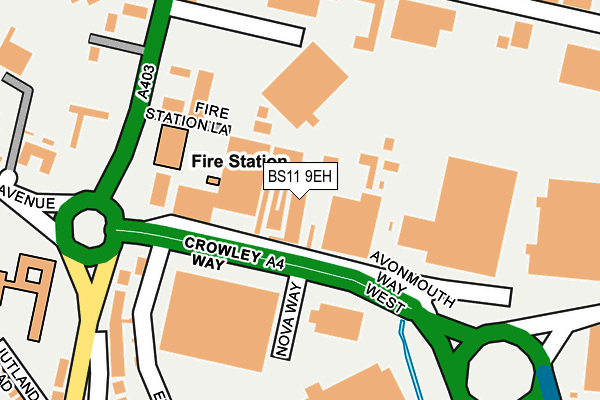
BS11 9EH is located in the Avonmouth and Lawrence Weston electoral ward, within the unitary authority of Bristol, City of and the English Parliamentary constituency of Bristol North West. The Sub Integrated Care Board (ICB) Location is NHS Bristol, North Somerset and South Gloucestershire ICB - 15C and the police force is Avon and Somerset. This postcode has been in use since December 1999.


GetTheData
Source: OS OpenMap – Local (Ordnance Survey)
Source: OS VectorMap District (Ordnance Survey)
Licence: Open Government Licence (requires attribution)
| Easting | 351857 |
| Northing | 178542 |
| Latitude | 51.503750 |
| Longitude | -2.695008 |
GetTheData
Source: Open Postcode Geo
Licence: Open Government Licence
| Country | England |
| Postcode District | BS11 |
➜ See where BS11 is on a map ➜ Where is Avonmouth? | |
GetTheData
Source: Land Registry Price Paid Data
Licence: Open Government Licence
Elevation or altitude of BS11 9EH as distance above sea level:
| Metres | Feet | |
|---|---|---|
| Elevation | 10m | 33ft |
Elevation is measured from the approximate centre of the postcode, to the nearest point on an OS contour line from OS Terrain 50, which has contour spacing of ten vertical metres.
➜ How high above sea level am I? Find the elevation of your current position using your device's GPS.
GetTheData
Source: Open Postcode Elevation
Licence: Open Government Licence
| Ward | Avonmouth And Lawrence Weston |
| Constituency | Bristol North West |
GetTheData
Source: ONS Postcode Database
Licence: Open Government Licence
| Third Way | Avonmouth | 336m |
| Mclaren Road | Avonmouth | 375m |
| St Brendan's Way (Saint Andrews Road) | Avonmouth | 379m |
| Mclaren Road | Avonmouth | 392m |
| First Way (Avonmouth Way) | Avonmouth | 420m |
| Avonmouth Station | 0.5km |
| St Andrews Road Station | 1km |
| Shirehampton Station | 2.4km |
GetTheData
Source: NaPTAN
Licence: Open Government Licence
GetTheData
Source: ONS Postcode Database
Licence: Open Government Licence

➜ Get more ratings from the Food Standards Agency
GetTheData
Source: Food Standards Agency
Licence: FSA terms & conditions
| Last Collection | |||
|---|---|---|---|
| Location | Mon-Fri | Sat | Distance |
| Avonmouth Way | 18:30 | 399m | |
| Avonmouth Post Office | 18:30 | 12:45 | 472m |
| Avonmouth Road Post Office | 17:15 | 12:30 | 516m |
GetTheData
Source: Dracos
Licence: Creative Commons Attribution-ShareAlike
| Risk of BS11 9EH flooding from rivers and sea | Low |
| ➜ BS11 9EH flood map | |
GetTheData
Source: Open Flood Risk by Postcode
Licence: Open Government Licence
The below table lists the International Territorial Level (ITL) codes (formerly Nomenclature of Territorial Units for Statistics (NUTS) codes) and Local Administrative Units (LAU) codes for BS11 9EH:
| ITL 1 Code | Name |
|---|---|
| TLK | South West (England) |
| ITL 2 Code | Name |
| TLK1 | Gloucestershire, Wiltshire and Bath/Bristol area |
| ITL 3 Code | Name |
| TLK11 | Bristol, City of |
| LAU 1 Code | Name |
| E06000023 | Bristol, City of |
GetTheData
Source: ONS Postcode Directory
Licence: Open Government Licence
The below table lists the Census Output Area (OA), Lower Layer Super Output Area (LSOA), and Middle Layer Super Output Area (MSOA) for BS11 9EH:
| Code | Name | |
|---|---|---|
| OA | E00073211 | |
| LSOA | E01014496 | Bristol 008E |
| MSOA | E02003019 | Bristol 008 |
GetTheData
Source: ONS Postcode Directory
Licence: Open Government Licence
| BS11 9ET | St Andrews Road | 232m |
| BS11 9DQ | St Andrews Road | 279m |
| BS11 9YT | Motorway Distribution Centre | 296m |
| BS11 9ES | St Andrews Road | 313m |
| BS11 9HF | King Road Avenue | 331m |
| BS11 9EU | St Andrews Road | 343m |
| BS11 9ER | Jutland Road | 345m |
| BS11 9EP | Richmond Villas | 392m |
| BS11 9EW | Richmond Terrace | 424m |
| BS11 9FP | St Andrews Road | 435m |
GetTheData
Source: Open Postcode Geo; Land Registry Price Paid Data
Licence: Open Government Licence