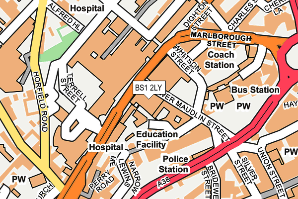
BS1 2LY is located in the Central electoral ward, within the unitary authority of Bristol, City of and the English Parliamentary constituency of Bristol West. The Sub Integrated Care Board (ICB) Location is NHS Bristol, North Somerset and South Gloucestershire ICB - 15C and the police force is Avon and Somerset. This postcode has been in use since January 1980.


GetTheData
Source: OS OpenMap – Local (Ordnance Survey)
Source: OS VectorMap District (Ordnance Survey)
Licence: Open Government Licence (requires attribution)
| Easting | 358744 |
| Northing | 173461 |
| Latitude | 51.458613 |
| Longitude | -2.595196 |
GetTheData
Source: Open Postcode Geo
Licence: Open Government Licence
| Country | England |
| Postcode District | BS1 |
➜ See where BS1 is on a map ➜ Where is Bristol? | |
GetTheData
Source: Land Registry Price Paid Data
Licence: Open Government Licence
Elevation or altitude of BS1 2LY as distance above sea level:
| Metres | Feet | |
|---|---|---|
| Elevation | 20m | 66ft |
Elevation is measured from the approximate centre of the postcode, to the nearest point on an OS contour line from OS Terrain 50, which has contour spacing of ten vertical metres.
➜ How high above sea level am I? Find the elevation of your current position using your device's GPS.
GetTheData
Source: Open Postcode Elevation
Licence: Open Government Licence
| Ward | Central |
| Constituency | Bristol West |
GetTheData
Source: ONS Postcode Database
Licence: Open Government Licence
| Bri (Upper Maudlin Street) | Kingsdown | 45m |
| Bri | Kingsdown | 61m |
| Bri | Kingsdown | 66m |
| Lewins Mead | Broadmead | 125m |
| Lewins Mead | Broadmead | 128m |
| Redland Station | 1.1km |
| Montpelier Station | 1.2km |
| Clifton Down Station | 1.3km |
GetTheData
Source: NaPTAN
Licence: Open Government Licence
GetTheData
Source: ONS Postcode Database
Licence: Open Government Licence


➜ Get more ratings from the Food Standards Agency
GetTheData
Source: Food Standards Agency
Licence: FSA terms & conditions
| Last Collection | |||
|---|---|---|---|
| Location | Mon-Fri | Sat | Distance |
| Marlborough Street | 17:15 | 12:15 | 64m |
| Bristol Royal Infirmary | 17:45 | 12:45 | 102m |
| Horfield Road | 17:45 | 12:30 | 205m |
GetTheData
Source: Dracos
Licence: Creative Commons Attribution-ShareAlike
The below table lists the International Territorial Level (ITL) codes (formerly Nomenclature of Territorial Units for Statistics (NUTS) codes) and Local Administrative Units (LAU) codes for BS1 2LY:
| ITL 1 Code | Name |
|---|---|
| TLK | South West (England) |
| ITL 2 Code | Name |
| TLK1 | Gloucestershire, Wiltshire and Bath/Bristol area |
| ITL 3 Code | Name |
| TLK11 | Bristol, City of |
| LAU 1 Code | Name |
| E06000023 | Bristol, City of |
GetTheData
Source: ONS Postcode Directory
Licence: Open Government Licence
The below table lists the Census Output Area (OA), Lower Layer Super Output Area (LSOA), and Middle Layer Super Output Area (MSOA) for BS1 2LY:
| Code | Name | |
|---|---|---|
| OA | E00174312 | |
| LSOA | E01014542 | Bristol 032C |
| MSOA | E02003043 | Bristol 032 |
GetTheData
Source: ONS Postcode Directory
Licence: Open Government Licence
| BS2 8DJ | Upper Maudlin Street | 183m |
| BS1 3LH | St James Parade | 192m |
| BS1 5BD | Colston Yard | 206m |
| BS2 8EA | Horfield Road | 216m |
| BS1 2AG | Silver Street | 216m |
| BS1 2PZ | Rupert Street | 227m |
| BS2 8DU | Gloucester Place | 229m |
| BS2 8DT | St Michaels Hill | 236m |
| BS2 8NY | Montague Street | 242m |
| BS2 8NZ | Montague Street | 242m |
GetTheData
Source: Open Postcode Geo; Land Registry Price Paid Data
Licence: Open Government Licence