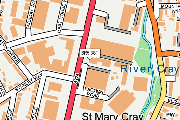
BR5 3ST is located in the St Mary Cray electoral ward, within the London borough of Bromley and the English Parliamentary constituency of Orpington. The Sub Integrated Care Board (ICB) Location is NHS South East London ICB - 72Q and the police force is Metropolitan Police. This postcode has been in use since December 1995.


GetTheData
Source: OS OpenMap – Local (Ordnance Survey)
Source: OS VectorMap District (Ordnance Survey)
Licence: Open Government Licence (requires attribution)
| Easting | 547050 |
| Northing | 167969 |
| Latitude | 51.391712 |
| Longitude | 0.112164 |
GetTheData
Source: Open Postcode Geo
Licence: Open Government Licence
| Country | England |
| Postcode District | BR5 |
➜ See where BR5 is on a map ➜ Where is Orpington? | |
GetTheData
Source: Land Registry Price Paid Data
Licence: Open Government Licence
Elevation or altitude of BR5 3ST as distance above sea level:
| Metres | Feet | |
|---|---|---|
| Elevation | 50m | 164ft |
Elevation is measured from the approximate centre of the postcode, to the nearest point on an OS contour line from OS Terrain 50, which has contour spacing of ten vertical metres.
➜ How high above sea level am I? Find the elevation of your current position using your device's GPS.
GetTheData
Source: Open Postcode Elevation
Licence: Open Government Licence
| Ward | St Mary Cray |
| Constituency | Orpington |
GetTheData
Source: ONS Postcode Database
Licence: Open Government Licence
| Nugent Retail Park (Cray Avenue) | St Mary Cray | 96m |
| Nugent Retail Park (Cray Avenue) | St Mary Cray | 153m |
| Blacksmiths Lane (St Mary Cray High Street) | St Mary Cray | 187m |
| Stanley Way | Derry Downs | 188m |
| Blacksmiths Lane (St Mary Cray High Street) | St Mary Cray | 194m |
| St Mary Cray Station | 0.5km |
| Orpington Station | 2.6km |
| Petts Wood Station | 2.6km |
GetTheData
Source: NaPTAN
Licence: Open Government Licence
GetTheData
Source: ONS Postcode Database
Licence: Open Government Licence


➜ Get more ratings from the Food Standards Agency
GetTheData
Source: Food Standards Agency
Licence: FSA terms & conditions
| Last Collection | |||
|---|---|---|---|
| Location | Mon-Fri | Sat | Distance |
| Stanley Way | 18:30 | 12:00 | 123m |
| Cray Avenue (Comet) | 166m | ||
| St Marys Cray P.o. | 18:00 | 12:00 | 317m |
GetTheData
Source: Dracos
Licence: Creative Commons Attribution-ShareAlike
| Risk of BR5 3ST flooding from rivers and sea | Medium |
| ➜ BR5 3ST flood map | |
GetTheData
Source: Open Flood Risk by Postcode
Licence: Open Government Licence
The below table lists the International Territorial Level (ITL) codes (formerly Nomenclature of Territorial Units for Statistics (NUTS) codes) and Local Administrative Units (LAU) codes for BR5 3ST:
| ITL 1 Code | Name |
|---|---|
| TLI | London |
| ITL 2 Code | Name |
| TLI6 | Outer London - South |
| ITL 3 Code | Name |
| TLI61 | Bromley |
| LAU 1 Code | Name |
| E09000006 | Bromley |
GetTheData
Source: ONS Postcode Directory
Licence: Open Government Licence
The below table lists the Census Output Area (OA), Lower Layer Super Output Area (LSOA), and Middle Layer Super Output Area (MSOA) for BR5 3ST:
| Code | Name | |
|---|---|---|
| OA | E00003519 | |
| LSOA | E01000722 | Bromley 023A |
| MSOA | E02000149 | Bromley 023 |
GetTheData
Source: ONS Postcode Directory
Licence: Open Government Licence
| BR5 3QX | Lagoon Road | 145m |
| BR5 3RD | Cray View Close | 226m |
| BR5 3NH | High Street | 228m |
| BR5 4AY | High Street | 235m |
| BR5 3FL | Ridge Place | 241m |
| BR5 4EW | Blacksmiths Lane | 242m |
| BR5 3FD | Mountfield Way | 245m |
| BR5 3FN | Ridge Place | 265m |
| BR5 3NW | Market Meadow | 284m |
| BR5 3FJ | Okemore Gardens | 287m |
GetTheData
Source: Open Postcode Geo; Land Registry Price Paid Data
Licence: Open Government Licence