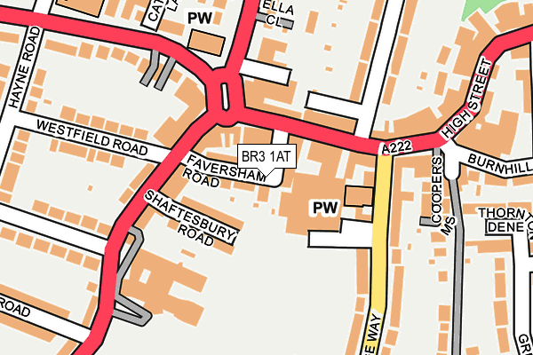
BR3 1AT is located in the Beckenham Town & Copers Cope electoral ward, within the London borough of Bromley and the English Parliamentary constituency of Beckenham. The Sub Integrated Care Board (ICB) Location is NHS South East London ICB - 72Q and the police force is Metropolitan Police. This postcode has been in use since January 1995.


GetTheData
Source: OS OpenMap – Local (Ordnance Survey)
Source: OS VectorMap District (Ordnance Survey)
Licence: Open Government Licence (requires attribution)
| Easting | 537023 |
| Northing | 169303 |
| Latitude | 51.406208 |
| Longitude | -0.031369 |
GetTheData
Source: Open Postcode Geo
Licence: Open Government Licence
| Country | England |
| Postcode District | BR3 |
➜ See where BR3 is on a map ➜ Where is Beckenham? | |
GetTheData
Source: Land Registry Price Paid Data
Licence: Open Government Licence
Elevation or altitude of BR3 1AT as distance above sea level:
| Metres | Feet | |
|---|---|---|
| Elevation | 40m | 131ft |
Elevation is measured from the approximate centre of the postcode, to the nearest point on an OS contour line from OS Terrain 50, which has contour spacing of ten vertical metres.
➜ How high above sea level am I? Find the elevation of your current position using your device's GPS.
GetTheData
Source: Open Postcode Elevation
Licence: Open Government Licence
| Ward | Beckenham Town & Copers Cope |
| Constituency | Beckenham |
GetTheData
Source: ONS Postcode Database
Licence: Open Government Licence
| Beckenham High Street War Memorial | Beckenham | 58m |
| Beckenham High Street War Memorial | Beckenham | 81m |
| Croydon Road War Memorial | Beckenham | 98m |
| Croydon Road War Memorial (Croydon Road) | Beckenham | 105m |
| St Edmund's Hall (Village Way) | Beckenham | 113m |
| Beckenham Junction Tram Stop (Rectory Road) | Beckenham | 610m |
| Beckenham Road Tram Stop (Beckenham Road) | Penge & Sydenham | 916m |
| Avenue Road Tram Stop (Avenue Road) | Penge & Sydenham | 1,261m |
| Elmers End Tram Stop (Off Elmers End Road) | Elmers End | 1,530m |
| Beckenham Junction Station | 0.7km |
| Clock House Station | 0.7km |
| Kent House Station | 1.2km |
GetTheData
Source: NaPTAN
Licence: Open Government Licence
Estimated total energy consumption in BR3 1AT by fuel type, 2015.
| Consumption (kWh) | 20,870 |
|---|---|
| Meter count | 7 |
| Mean (kWh/meter) | 2,981 |
| Median (kWh/meter) | 3,102 |
GetTheData
Source: Postcode level gas estimates: 2015 (experimental)
Source: Postcode level electricity estimates: 2015 (experimental)
Licence: Open Government Licence
GetTheData
Source: ONS Postcode Database
Licence: Open Government Licence


➜ Get more ratings from the Food Standards Agency
GetTheData
Source: Food Standards Agency
Licence: FSA terms & conditions
| Last Collection | |||
|---|---|---|---|
| Location | Mon-Fri | Sat | Distance |
| Beckenham P.o. | 18:30 | 12:00 | 139m |
| Cedars Road (2) | 17:45 | 12:00 | 196m |
| High Street (15 - Upper) | 18:30 | 12:00 | 298m |
GetTheData
Source: Dracos
Licence: Creative Commons Attribution-ShareAlike
The below table lists the International Territorial Level (ITL) codes (formerly Nomenclature of Territorial Units for Statistics (NUTS) codes) and Local Administrative Units (LAU) codes for BR3 1AT:
| ITL 1 Code | Name |
|---|---|
| TLI | London |
| ITL 2 Code | Name |
| TLI6 | Outer London - South |
| ITL 3 Code | Name |
| TLI61 | Bromley |
| LAU 1 Code | Name |
| E09000006 | Bromley |
GetTheData
Source: ONS Postcode Directory
Licence: Open Government Licence
The below table lists the Census Output Area (OA), Lower Layer Super Output Area (LSOA), and Middle Layer Super Output Area (MSOA) for BR3 1AT:
| Code | Name | |
|---|---|---|
| OA | E00003474 | |
| LSOA | E01000714 | Bromley 006D |
| MSOA | E02000132 | Bromley 006 |
GetTheData
Source: ONS Postcode Directory
Licence: Open Government Licence
| BR3 3PN | Faversham Road | 52m |
| BR3 1BN | High Street | 57m |
| BR3 1DY | High Street | 76m |
| BR3 1AH | High Street | 83m |
| BR3 1DZ | High Street | 89m |
| BR3 3PP | Croydon Road | 90m |
| BR3 3PW | Shaftesbury Road | 101m |
| BR3 1XF | Rectory Road | 147m |
| BR3 3PR | Croydon Road | 152m |
| BR3 1AE | High Street | 166m |
GetTheData
Source: Open Postcode Geo; Land Registry Price Paid Data
Licence: Open Government Licence