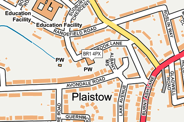
BR1 4PX is located in the Plaistow electoral ward, within the London borough of Bromley and the English Parliamentary constituency of Bromley and Chislehurst. The Sub Integrated Care Board (ICB) Location is NHS South East London ICB - 72Q and the police force is Metropolitan Police. This postcode has been in use since January 1980.


GetTheData
Source: OS OpenMap – Local (Ordnance Survey)
Source: OS VectorMap District (Ordnance Survey)
Licence: Open Government Licence (requires attribution)
| Easting | 540193 |
| Northing | 170901 |
| Latitude | 51.419793 |
| Longitude | 0.014808 |
GetTheData
Source: Open Postcode Geo
Licence: Open Government Licence
| Country | England |
| Postcode District | BR1 |
➜ See where BR1 is on a map ➜ Where is London? | |
GetTheData
Source: Land Registry Price Paid Data
Licence: Open Government Licence
Elevation or altitude of BR1 4PX as distance above sea level:
| Metres | Feet | |
|---|---|---|
| Elevation | 50m | 164ft |
Elevation is measured from the approximate centre of the postcode, to the nearest point on an OS contour line from OS Terrain 50, which has contour spacing of ten vertical metres.
➜ How high above sea level am I? Find the elevation of your current position using your device's GPS.
GetTheData
Source: Open Postcode Elevation
Licence: Open Government Licence
| Ward | Plaistow |
| Constituency | Bromley And Chislehurst |
GetTheData
Source: ONS Postcode Database
Licence: Open Government Licence
| Rangefield Road Southover | Plaistow | 103m |
| Rangefield Road Southover (Rangefield Road) | Plaistow | 116m |
| Brook Lane (Br1) (Southover) | Plaistow | 126m |
| Burnt Ash Primary School (Rangefield Road) | Plaistow | 160m |
| Brook Lane (Br1) (Southover) | Plaistow | 168m |
| Sundridge Park Station | 0.8km |
| Bromley North Station | 1.3km |
| Grove Park Station | 1.3km |
GetTheData
Source: NaPTAN
Licence: Open Government Licence
GetTheData
Source: ONS Postcode Database
Licence: Open Government Licence


➜ Get more ratings from the Food Standards Agency
GetTheData
Source: Food Standards Agency
Licence: FSA terms & conditions
| Last Collection | |||
|---|---|---|---|
| Location | Mon-Fri | Sat | Distance |
| Avondale Crescent (66) | 18:30 | 12:00 | 311m |
| Park Avenue (47) | 18:30 | 12:00 | 344m |
| Kings Avenue (39) | 18:30 | 12:00 | 556m |
GetTheData
Source: Dracos
Licence: Creative Commons Attribution-ShareAlike
The below table lists the International Territorial Level (ITL) codes (formerly Nomenclature of Territorial Units for Statistics (NUTS) codes) and Local Administrative Units (LAU) codes for BR1 4PX:
| ITL 1 Code | Name |
|---|---|
| TLI | London |
| ITL 2 Code | Name |
| TLI6 | Outer London - South |
| ITL 3 Code | Name |
| TLI61 | Bromley |
| LAU 1 Code | Name |
| E09000006 | Bromley |
GetTheData
Source: ONS Postcode Directory
Licence: Open Government Licence
The below table lists the Census Output Area (OA), Lower Layer Super Output Area (LSOA), and Middle Layer Super Output Area (MSOA) for BR1 4PX:
| Code | Name | |
|---|---|---|
| OA | E00004020 | |
| LSOA | E01000819 | Bromley 040C |
| MSOA | E02006782 | Bromley 040 |
GetTheData
Source: ONS Postcode Directory
Licence: Open Government Licence
| BR1 4HU | Albany Mews | 46m |
| BR1 4PU | Brook Lane | 67m |
| BR1 4EP | Avondale Road | 71m |
| BR1 4HT | Avondale Road | 93m |
| BR1 4ER | Avondale Road | 116m |
| BR1 4QY | Rangefield Road | 128m |
| BR1 4PZ | Sudbury Crescent | 141m |
| BR1 4RU | Southover | 144m |
| BR1 4PY | Sudbury Crescent | 153m |
| BR1 4EN | Lake Avenue | 187m |
GetTheData
Source: Open Postcode Geo; Land Registry Price Paid Data
Licence: Open Government Licence