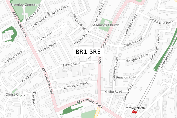
BR1 3RE lies on Farwig Lane in Bromley. BR1 3RE is located in the Plaistow electoral ward, within the London borough of Bromley and the English Parliamentary constituency of Bromley and Chislehurst. The Sub Integrated Care Board (ICB) Location is NHS South East London ICB - 72Q and the police force is Metropolitan Police. This postcode has been in use since January 1980.


GetTheData
Source: OS Open Zoomstack (Ordnance Survey)
Licence: Open Government Licence (requires attribution)
Attribution: Contains OS data © Crown copyright and database right 2025
Source: Open Postcode Geo
Licence: Open Government Licence (requires attribution)
Attribution: Contains OS data © Crown copyright and database right 2025; Contains Royal Mail data © Royal Mail copyright and database right 2025; Source: Office for National Statistics licensed under the Open Government Licence v.3.0
| Easting | 540127 |
| Northing | 169955 |
| Latitude | 51.411309 |
| Longitude | 0.013486 |
GetTheData
Source: Open Postcode Geo
Licence: Open Government Licence
| Street | Farwig Lane |
| Town/City | Bromley |
| Country | England |
| Postcode District | BR1 |
➜ See where BR1 is on a map ➜ Where is Bromley? | |
GetTheData
Source: Land Registry Price Paid Data
Licence: Open Government Licence
Elevation or altitude of BR1 3RE as distance above sea level:
| Metres | Feet | |
|---|---|---|
| Elevation | 70m | 230ft |
Elevation is measured from the approximate centre of the postcode, to the nearest point on an OS contour line from OS Terrain 50, which has contour spacing of ten vertical metres.
➜ How high above sea level am I? Find the elevation of your current position using your device's GPS.
GetTheData
Source: Open Postcode Elevation
Licence: Open Government Licence
| Ward | Plaistow |
| Constituency | Bromley And Chislehurst |
GetTheData
Source: ONS Postcode Database
Licence: Open Government Licence
| Hammelton Road (College Road) | Bromley | 128m |
| Hammelton Road (College Road) | Bromley | 161m |
| Morgan Road (College Road) | Plaistow | 161m |
| Morgan Road (College Road) | Plaistow | 191m |
| Farwig Lane | Bromley Park | 250m |
| Bromley North Station | 0.4km |
| Sundridge Park Station | 0.6km |
| Shortlands Station | 1km |
GetTheData
Source: NaPTAN
Licence: Open Government Licence
GetTheData
Source: ONS Postcode Database
Licence: Open Government Licence


➜ Get more ratings from the Food Standards Agency
GetTheData
Source: Food Standards Agency
Licence: FSA terms & conditions
| Last Collection | |||
|---|---|---|---|
| Location | Mon-Fri | Sat | Distance |
| College Road (52) | 18:00 | 12:00 | 75m |
| Cambridge Road (Opp' 1) | 18:00 | 12:00 | 199m |
| Aldermary Road (Opp' 19) | 18:00 | 12:00 | 221m |
GetTheData
Source: Dracos
Licence: Creative Commons Attribution-ShareAlike
The below table lists the International Territorial Level (ITL) codes (formerly Nomenclature of Territorial Units for Statistics (NUTS) codes) and Local Administrative Units (LAU) codes for BR1 3RE:
| ITL 1 Code | Name |
|---|---|
| TLI | London |
| ITL 2 Code | Name |
| TLI6 | Outer London - South |
| ITL 3 Code | Name |
| TLI61 | Bromley |
| LAU 1 Code | Name |
| E09000006 | Bromley |
GetTheData
Source: ONS Postcode Directory
Licence: Open Government Licence
The below table lists the Census Output Area (OA), Lower Layer Super Output Area (LSOA), and Middle Layer Super Output Area (MSOA) for BR1 3RE:
| Code | Name | |
|---|---|---|
| OA | E00004030 | |
| LSOA | E01000824 | Bromley 008F |
| MSOA | E02000134 | Bromley 008 |
GetTheData
Source: ONS Postcode Directory
Licence: Open Government Licence
| BR1 3PU | College Road | 55m |
| BR1 3QD | Scotts Road | 67m |
| BR1 3RF | Farwig Lane | 78m |
| BR1 3PE | College Road | 93m |
| BR1 3QJ | Howard Road | 131m |
| BR1 3PZ | Hammelton Road | 137m |
| BR1 3RD | Mooreland Road | 151m |
| BR1 3RB | Farwig Lane | 154m |
| BR1 3PT | College Road | 170m |
| BR1 3PH | Aldermary Road | 171m |
GetTheData
Source: Open Postcode Geo; Land Registry Price Paid Data
Licence: Open Government Licence