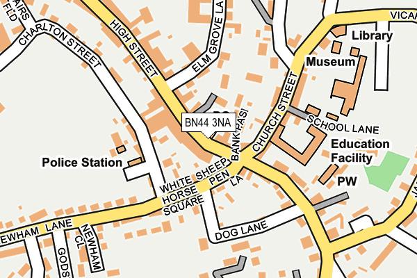
BN44 3NA is located in the Steyning & Ashurst electoral ward, within the local authority district of Horsham and the English Parliamentary constituency of Arundel and South Downs. The Sub Integrated Care Board (ICB) Location is NHS Sussex ICB - 70F and the police force is Sussex. This postcode has been in use since February 1990.


GetTheData
Source: OS OpenMap – Local (Ordnance Survey)
Source: OS VectorMap District (Ordnance Survey)
Licence: Open Government Licence (requires attribution)
| Easting | 517642 |
| Northing | 111190 |
| Latitude | 50.888221 |
| Longitude | -0.328822 |
GetTheData
Source: Open Postcode Geo
Licence: Open Government Licence
| Country | England |
| Postcode District | BN44 |
➜ See where BN44 is on a map ➜ Where is Steyning? | |
GetTheData
Source: Land Registry Price Paid Data
Licence: Open Government Licence
Elevation or altitude of BN44 3NA as distance above sea level:
| Metres | Feet | |
|---|---|---|
| Elevation | 20m | 66ft |
Elevation is measured from the approximate centre of the postcode, to the nearest point on an OS contour line from OS Terrain 50, which has contour spacing of ten vertical metres.
➜ How high above sea level am I? Find the elevation of your current position using your device's GPS.
GetTheData
Source: Open Postcode Elevation
Licence: Open Government Licence
| Ward | Steyning & Ashurst |
| Constituency | Arundel And South Downs |
GetTheData
Source: ONS Postcode Database
Licence: Open Government Licence
| Clock Tower (High Street) | Steyning | 116m |
| Clock Tower (High Street) | Steyning | 128m |
| Church Street | Steyning | 137m |
| Bramber Road (High Street) | Steyning | 148m |
| Bramber Road (High Street) | Steyning | 173m |
GetTheData
Source: NaPTAN
Licence: Open Government Licence
GetTheData
Source: ONS Postcode Database
Licence: Open Government Licence


➜ Get more ratings from the Food Standards Agency
GetTheData
Source: Food Standards Agency
Licence: FSA terms & conditions
| Last Collection | |||
|---|---|---|---|
| Location | Mon-Fri | Sat | Distance |
| The High Street Post Office | 18:00 | 12:30 | 6m |
| Thornscroft | 17:45 | 11:30 | 366m |
| Station Road | 17:45 | 11:30 | 383m |
GetTheData
Source: Dracos
Licence: Creative Commons Attribution-ShareAlike
The below table lists the International Territorial Level (ITL) codes (formerly Nomenclature of Territorial Units for Statistics (NUTS) codes) and Local Administrative Units (LAU) codes for BN44 3NA:
| ITL 1 Code | Name |
|---|---|
| TLJ | South East (England) |
| ITL 2 Code | Name |
| TLJ2 | Surrey, East and West Sussex |
| ITL 3 Code | Name |
| TLJ28 | West Sussex (North East) |
| LAU 1 Code | Name |
| E07000227 | Horsham |
GetTheData
Source: ONS Postcode Directory
Licence: Open Government Licence
The below table lists the Census Output Area (OA), Lower Layer Super Output Area (LSOA), and Middle Layer Super Output Area (MSOA) for BN44 3NA:
| Code | Name | |
|---|---|---|
| OA | E00161572 | |
| LSOA | E01031685 | Horsham 016D |
| MSOA | E02006603 | Horsham 016 |
GetTheData
Source: ONS Postcode Directory
Licence: Open Government Licence
| BN44 3YE | High Street | 11m |
| BN44 3YA | Bank Passage | 42m |
| BN44 3SB | Borough Gate | 73m |
| BN44 3GP | Sheep Pen Lane | 79m |
| BN44 3NF | Charlton Mews | 93m |
| BN44 3RB | Elm Terrace | 96m |
| BN44 3RA | Elm Grove Lane | 109m |
| BN44 3GQ | White Horse Square | 110m |
| BN44 3LU | Charlton Street | 116m |
| BN44 3YB | Church Street | 124m |
GetTheData
Source: Open Postcode Geo; Land Registry Price Paid Data
Licence: Open Government Licence