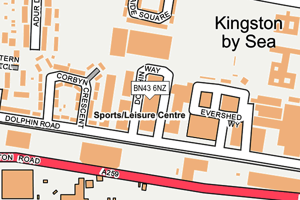
BN43 6NZ lies on Dolphin Way in Shoreham-by-sea. BN43 6NZ is located in the St Mary's electoral ward, within the local authority district of Adur and the English Parliamentary constituency of East Worthing and Shoreham. The Sub Integrated Care Board (ICB) Location is NHS Sussex ICB - 70F and the police force is Sussex. This postcode has been in use since January 1992.


GetTheData
Source: OS OpenMap – Local (Ordnance Survey)
Source: OS VectorMap District (Ordnance Survey)
Licence: Open Government Licence (requires attribution)
| Easting | 522631 |
| Northing | 105259 |
| Latitude | 50.833875 |
| Longitude | -0.259912 |
GetTheData
Source: Open Postcode Geo
Licence: Open Government Licence
| Street | Dolphin Way |
| Town/City | Shoreham-by-sea |
| Country | England |
| Postcode District | BN43 |
➜ See where BN43 is on a map ➜ Where is Shoreham-by-Sea? | |
GetTheData
Source: Land Registry Price Paid Data
Licence: Open Government Licence
Elevation or altitude of BN43 6NZ as distance above sea level:
| Metres | Feet | |
|---|---|---|
| Elevation | 10m | 33ft |
Elevation is measured from the approximate centre of the postcode, to the nearest point on an OS contour line from OS Terrain 50, which has contour spacing of ten vertical metres.
➜ How high above sea level am I? Find the elevation of your current position using your device's GPS.
GetTheData
Source: Open Postcode Elevation
Licence: Open Government Licence
| Ward | St Mary's |
| Constituency | East Worthing And Shoreham |
GetTheData
Source: ONS Postcode Database
Licence: Open Government Licence
| Amenity Tip (Brighton Road A259) | Shoreham-by-sea | 174m |
| Amenity Tip (Brighton Road A259) | Shoreham-by-sea | 187m |
| Adelaide Square (Middle Road) | Shoreham-by-sea | 244m |
| Adelaide Square (Middle Road) | Shoreham-by-sea | 252m |
| Hammy Lane (Middle Road) | Shoreham-by-sea | 312m |
| Shoreham-by-Sea (Sussex) Station | 0.8km |
| Southwick Station | 1.7km |
| Fishersgate Station | 2.9km |
GetTheData
Source: NaPTAN
Licence: Open Government Licence
Estimated total energy consumption in BN43 6NZ by fuel type, 2015.
| Consumption (kWh) | 266,662 |
|---|---|
| Meter count | 9 |
| Mean (kWh/meter) | 29,629 |
| Median (kWh/meter) | 16,102 |
GetTheData
Source: Postcode level gas estimates: 2015 (experimental)
Source: Postcode level electricity estimates: 2015 (experimental)
Licence: Open Government Licence
GetTheData
Source: ONS Postcode Database
Licence: Open Government Licence


➜ Get more ratings from the Food Standards Agency
GetTheData
Source: Food Standards Agency
Licence: FSA terms & conditions
| Last Collection | |||
|---|---|---|---|
| Location | Mon-Fri | Sat | Distance |
| Dolphin Road | 18:15 | 12:30 | 162m |
| Middle Road | 18:15 | 12:15 | 326m |
| Winterton Way | 17:15 | 12:00 | 496m |
GetTheData
Source: Dracos
Licence: Creative Commons Attribution-ShareAlike
The below table lists the International Territorial Level (ITL) codes (formerly Nomenclature of Territorial Units for Statistics (NUTS) codes) and Local Administrative Units (LAU) codes for BN43 6NZ:
| ITL 1 Code | Name |
|---|---|
| TLJ | South East (England) |
| ITL 2 Code | Name |
| TLJ2 | Surrey, East and West Sussex |
| ITL 3 Code | Name |
| TLJ27 | West Sussex (South West) |
| LAU 1 Code | Name |
| E07000223 | Adur |
GetTheData
Source: ONS Postcode Directory
Licence: Open Government Licence
The below table lists the Census Output Area (OA), Lower Layer Super Output Area (LSOA), and Middle Layer Super Output Area (MSOA) for BN43 6NZ:
| Code | Name | |
|---|---|---|
| OA | E00159925 | |
| LSOA | E01031366 | Adur 004C |
| MSOA | E02006537 | Adur 004 |
GetTheData
Source: ONS Postcode Directory
Licence: Open Government Licence
| BN43 6PB | Dolphin Road | 86m |
| BN43 6RJ | Brighton Road | 156m |
| BN43 6PQ | Corbyn Crescent | 164m |
| BN43 6LN | Adelaide Square | 178m |
| BN43 6PU | Eastern Close | 259m |
| BN43 6GA | Middle Road | 262m |
| BN43 6PL | Adur Drive | 272m |
| BN43 6GS | Middle Road | 293m |
| BN43 6GB | Crown Road | 312m |
| BN43 6PN | Adur Drive | 313m |
GetTheData
Source: Open Postcode Geo; Land Registry Price Paid Data
Licence: Open Government Licence