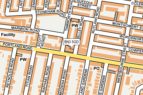
BN3 5GD is located in the Westbourne & Poets' Corner electoral ward, within the unitary authority of Brighton and Hove and the English Parliamentary constituency of Hove. The Sub Integrated Care Board (ICB) Location is NHS Sussex ICB - 09D and the police force is Sussex. This postcode has been in use since January 1980.


GetTheData
Source: OS OpenMap – Local (Ordnance Survey)
Source: OS VectorMap District (Ordnance Survey)
Licence: Open Government Licence (requires attribution)
| Easting | 527932 |
| Northing | 105347 |
| Latitude | 50.833526 |
| Longitude | -0.184671 |
GetTheData
Source: Open Postcode Geo
Licence: Open Government Licence
| Country | England |
| Postcode District | BN3 |
➜ See where BN3 is on a map ➜ Where is Brighton and Hove? | |
GetTheData
Source: Land Registry Price Paid Data
Licence: Open Government Licence
Elevation or altitude of BN3 5GD as distance above sea level:
| Metres | Feet | |
|---|---|---|
| Elevation | 20m | 66ft |
Elevation is measured from the approximate centre of the postcode, to the nearest point on an OS contour line from OS Terrain 50, which has contour spacing of ten vertical metres.
➜ How high above sea level am I? Find the elevation of your current position using your device's GPS.
GetTheData
Source: Open Postcode Elevation
Licence: Open Government Licence
| Ward | Westbourne & Poets' Corner |
| Constituency | Hove |
GetTheData
Source: ONS Postcode Database
Licence: Open Government Licence
| Scott Road (Portland Road) | Hove | 94m |
| Scott Road (Portland Road) | Hove | 195m |
| Westbourne Street (Portland Road) | Hove | 196m |
| Westbourne Street (Portland Road) | Hove | 244m |
| School Road (Portland Road) | Hove | 349m |
| Aldrington Station | 0.3km |
| Hove Station | 1km |
| Portslade Station | 1.5km |
GetTheData
Source: NaPTAN
Licence: Open Government Licence
GetTheData
Source: ONS Postcode Database
Licence: Open Government Licence


➜ Get more ratings from the Food Standards Agency
GetTheData
Source: Food Standards Agency
Licence: FSA terms & conditions
| Last Collection | |||
|---|---|---|---|
| Location | Mon-Fri | Sat | Distance |
| Portland Road Post Office | 17:45 | 12:00 | 153m |
| Titian Road | 17:45 | 12:15 | 154m |
| Ruskin Road | 17:45 | 12:15 | 167m |
GetTheData
Source: Dracos
Licence: Creative Commons Attribution-ShareAlike
The below table lists the International Territorial Level (ITL) codes (formerly Nomenclature of Territorial Units for Statistics (NUTS) codes) and Local Administrative Units (LAU) codes for BN3 5GD:
| ITL 1 Code | Name |
|---|---|
| TLJ | South East (England) |
| ITL 2 Code | Name |
| TLJ2 | Surrey, East and West Sussex |
| ITL 3 Code | Name |
| TLJ21 | Brighton and Hove |
| LAU 1 Code | Name |
| E06000043 | Brighton and Hove |
GetTheData
Source: ONS Postcode Directory
Licence: Open Government Licence
The below table lists the Census Output Area (OA), Lower Layer Super Output Area (LSOA), and Middle Layer Super Output Area (MSOA) for BN3 5GD:
| Code | Name | |
|---|---|---|
| OA | E00085794 | |
| LSOA | E01016987 | Brighton and Hove 023A |
| MSOA | E02003513 | Brighton and Hove 023 |
GetTheData
Source: ONS Postcode Directory
Licence: Open Government Licence
| BN3 5QL | Portland Road | 51m |
| BN3 5FJ | Tamworth Road | 56m |
| BN3 5FQ | Shelley Road | 67m |
| BN3 5FF | Rutland Road | 88m |
| BN3 5FR | Marmion Road | 91m |
| BN3 5BL | Cowper Street | 146m |
| BN3 5FP | Montgomery Street | 147m |
| BN3 5DN | Portland Road | 150m |
| BN3 5DP | Portland Road | 151m |
| BN3 5PB | Rutland Gardens | 153m |
GetTheData
Source: Open Postcode Geo; Land Registry Price Paid Data
Licence: Open Government Licence