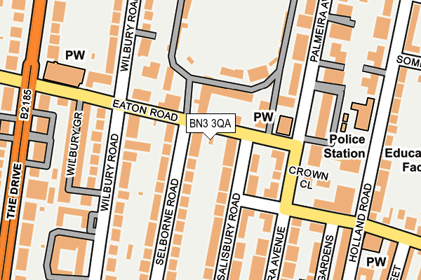
BN3 3QA is located in the Brunswick & Adelaide electoral ward, within the unitary authority of Brighton and Hove and the English Parliamentary constituency of Hove. The Sub Integrated Care Board (ICB) Location is NHS Sussex ICB - 09D and the police force is Sussex. This postcode has been in use since August 2002.


GetTheData
Source: OS OpenMap – Local (Ordnance Survey)
Source: OS VectorMap District (Ordnance Survey)
Licence: Open Government Licence (requires attribution)
| Easting | 529387 |
| Northing | 104926 |
| Latitude | 50.829419 |
| Longitude | -0.164169 |
GetTheData
Source: Open Postcode Geo
Licence: Open Government Licence
| Country | England |
| Postcode District | BN3 |
➜ See where BN3 is on a map ➜ Where is Brighton and Hove? | |
GetTheData
Source: Land Registry Price Paid Data
Licence: Open Government Licence
Elevation or altitude of BN3 3QA as distance above sea level:
| Metres | Feet | |
|---|---|---|
| Elevation | 20m | 66ft |
Elevation is measured from the approximate centre of the postcode, to the nearest point on an OS contour line from OS Terrain 50, which has contour spacing of ten vertical metres.
➜ How high above sea level am I? Find the elevation of your current position using your device's GPS.
GetTheData
Source: Open Postcode Elevation
Licence: Open Government Licence
| Ward | Brunswick & Adelaide |
| Constituency | Hove |
GetTheData
Source: ONS Postcode Database
Licence: Open Government Licence
| Cricket Ground (Eaton Road) | Hove | 12m |
| Cricket Ground (Eaton Road) | Hove | 56m |
| Selborne Road | Hove | 180m |
| Law Courts (Lansdowne Road) | Hove | 184m |
| Law Courts (Lansdowne Road) | Hove | 221m |
| Hove Station | 0.8km |
| Aldrington Station | 1.6km |
| Brighton Station | 1.6km |
GetTheData
Source: NaPTAN
Licence: Open Government Licence
GetTheData
Source: ONS Postcode Database
Licence: Open Government Licence


➜ Get more ratings from the Food Standards Agency
GetTheData
Source: Food Standards Agency
Licence: FSA terms & conditions
| Last Collection | |||
|---|---|---|---|
| Location | Mon-Fri | Sat | Distance |
| Eaton Road No.1 | 18:15 | 11:30 | 13m |
| Palmeira Avenue | 18:15 | 11:30 | 141m |
| Wilbury Road | 19:00 | 12:00 | 283m |
GetTheData
Source: Dracos
Licence: Creative Commons Attribution-ShareAlike
The below table lists the International Territorial Level (ITL) codes (formerly Nomenclature of Territorial Units for Statistics (NUTS) codes) and Local Administrative Units (LAU) codes for BN3 3QA:
| ITL 1 Code | Name |
|---|---|
| TLJ | South East (England) |
| ITL 2 Code | Name |
| TLJ2 | Surrey, East and West Sussex |
| ITL 3 Code | Name |
| TLJ21 | Brighton and Hove |
| LAU 1 Code | Name |
| E06000043 | Brighton and Hove |
GetTheData
Source: ONS Postcode Directory
Licence: Open Government Licence
The below table lists the Census Output Area (OA), Lower Layer Super Output Area (LSOA), and Middle Layer Super Output Area (MSOA) for BN3 3QA:
| Code | Name | |
|---|---|---|
| OA | E00085031 | |
| LSOA | E01016853 | Brighton and Hove 026C |
| MSOA | E02003516 | Brighton and Hove 026 |
GetTheData
Source: ONS Postcode Directory
Licence: Open Government Licence
| BN3 3AE | Salisbury Road | 35m |
| BN3 3AF | Eaton Road | 36m |
| BN3 3AH | Selborne Road | 39m |
| BN3 3AQ | Eaton Road | 78m |
| BN3 3AR | Eaton Road | 78m |
| BN3 3AL | Selborne Road | 79m |
| BN3 3AS | Eaton Road | 90m |
| BN3 3GD | Palmeira Avenue | 101m |
| BN3 1GB | Lansdowne Road | 113m |
| BN3 3AD | Salisbury Road | 122m |
GetTheData
Source: Open Postcode Geo; Land Registry Price Paid Data
Licence: Open Government Licence