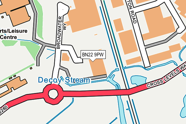
BN22 9PW is located in the Hampden Park electoral ward, within the local authority district of Eastbourne and the English Parliamentary constituency of Eastbourne. The Sub Integrated Care Board (ICB) Location is NHS Sussex ICB - 97R and the police force is Sussex. This postcode has been in use since May 1994.


GetTheData
Source: OS OpenMap – Local (Ordnance Survey)
Source: OS VectorMap District (Ordnance Survey)
Licence: Open Government Licence (requires attribution)
| Easting | 560796 |
| Northing | 101648 |
| Latitude | 50.792101 |
| Longitude | 0.280040 |
GetTheData
Source: Open Postcode Geo
Licence: Open Government Licence
| Country | England |
| Postcode District | BN22 |
➜ See where BN22 is on a map ➜ Where is Eastbourne? | |
GetTheData
Source: Land Registry Price Paid Data
Licence: Open Government Licence
Elevation or altitude of BN22 9PW as distance above sea level:
| Metres | Feet | |
|---|---|---|
| Elevation | 10m | 33ft |
Elevation is measured from the approximate centre of the postcode, to the nearest point on an OS contour line from OS Terrain 50, which has contour spacing of ten vertical metres.
➜ How high above sea level am I? Find the elevation of your current position using your device's GPS.
GetTheData
Source: Open Postcode Elevation
Licence: Open Government Licence
| Ward | Hampden Park |
| Constituency | Eastbourne |
GetTheData
Source: ONS Postcode Database
Licence: Open Government Licence
| Sainsburys (Broadwater Way) | Hampden Park | 135m |
| Hampden Park Railway Station (Station Approach) | Hampden Park | 463m |
| B&q (Lottbridge Drove) | Highfield | 533m |
| Sussex Downs College (College Grounds) | Hampden Park | 556m |
| Brassey Parade (Brassey Avenue) | Hampden Park | 585m |
| Hampden Park (Sussex) Station | 0.5km |
| Eastbourne Station | 2.5km |
| Polegate Station | 4.1km |
GetTheData
Source: NaPTAN
Licence: Open Government Licence
GetTheData
Source: ONS Postcode Database
Licence: Open Government Licence


➜ Get more ratings from the Food Standards Agency
GetTheData
Source: Food Standards Agency
Licence: FSA terms & conditions
| Last Collection | |||
|---|---|---|---|
| Location | Mon-Fri | Sat | Distance |
| Marshall Road | 17:15 | 11:00 | 297m |
| Hampden Park Post Office | 17:15 | 12:00 | 578m |
| Mountfield | 17:15 | 11:00 | 586m |
GetTheData
Source: Dracos
Licence: Creative Commons Attribution-ShareAlike
| Risk of BN22 9PW flooding from rivers and sea | Low |
| ➜ BN22 9PW flood map | |
GetTheData
Source: Open Flood Risk by Postcode
Licence: Open Government Licence
The below table lists the International Territorial Level (ITL) codes (formerly Nomenclature of Territorial Units for Statistics (NUTS) codes) and Local Administrative Units (LAU) codes for BN22 9PW:
| ITL 1 Code | Name |
|---|---|
| TLJ | South East (England) |
| ITL 2 Code | Name |
| TLJ2 | Surrey, East and West Sussex |
| ITL 3 Code | Name |
| TLJ22 | East Sussex CC |
| LAU 1 Code | Name |
| E07000061 | Eastbourne |
GetTheData
Source: ONS Postcode Directory
Licence: Open Government Licence
The below table lists the Census Output Area (OA), Lower Layer Super Output Area (LSOA), and Middle Layer Super Output Area (MSOA) for BN22 9PW:
| Code | Name | |
|---|---|---|
| OA | E00106195 | |
| LSOA | E01020922 | Eastbourne 004C |
| MSOA | E02004359 | Eastbourne 004 |
GetTheData
Source: ONS Postcode Directory
Licence: Open Government Licence
| BN22 9AD | Marshall Road | 281m |
| BN22 9NA | Mallard Close | 370m |
| BN22 9BN | Brampton Road | 399m |
| BN22 9NN | Elm Grove | 453m |
| BN22 9BH | Faraday Close | 455m |
| BN22 9NW | Elm Grove | 493m |
| BN22 9NJ | Edgeland Terrace | 497m |
| BN22 9QB | Rosebery Avenue | 509m |
| BN22 9NH | Brassey Avenue | 532m |
| BN22 9BL | Mountfield Road | 535m |
GetTheData
Source: Open Postcode Geo; Land Registry Price Paid Data
Licence: Open Government Licence