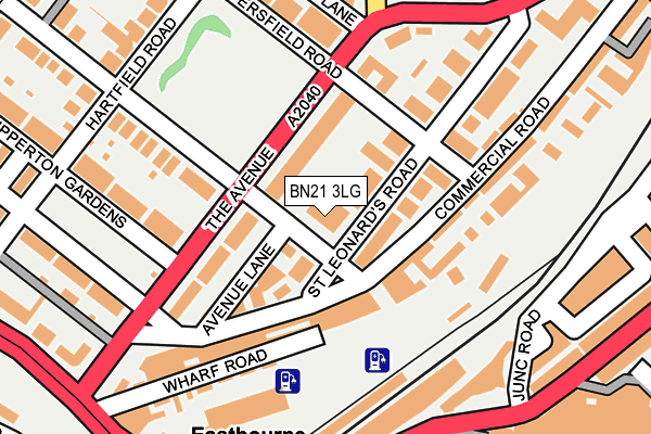
BN21 3LG is located in the Upperton electoral ward, within the local authority district of Eastbourne and the English Parliamentary constituency of Eastbourne. The Sub Integrated Care Board (ICB) Location is NHS Sussex ICB - 97R and the police force is Sussex. This postcode has been in use since January 1980.


GetTheData
Source: OS OpenMap – Local (Ordnance Survey)
Source: OS VectorMap District (Ordnance Survey)
Licence: Open Government Licence (requires attribution)
| Easting | 560987 |
| Northing | 99363 |
| Latitude | 50.771516 |
| Longitude | 0.281748 |
GetTheData
Source: Open Postcode Geo
Licence: Open Government Licence
| Country | England |
| Postcode District | BN21 |
➜ See where BN21 is on a map ➜ Where is Eastbourne? | |
GetTheData
Source: Land Registry Price Paid Data
Licence: Open Government Licence
Elevation or altitude of BN21 3LG as distance above sea level:
| Metres | Feet | |
|---|---|---|
| Elevation | 10m | 33ft |
Elevation is measured from the approximate centre of the postcode, to the nearest point on an OS contour line from OS Terrain 50, which has contour spacing of ten vertical metres.
➜ How high above sea level am I? Find the elevation of your current position using your device's GPS.
GetTheData
Source: Open Postcode Elevation
Licence: Open Government Licence
| Ward | Upperton |
| Constituency | Eastbourne |
GetTheData
Source: ONS Postcode Database
Licence: Open Government Licence
| Eversfield Road (The Avenue) | Eastbourne | 119m |
| Eversfield Road (The Avenue) | Eastbourne | 152m |
| Upperton Gardens (The Avenue) | Eastbourne | 176m |
| Junction Road Car Park (Junction Road) | Eastbourne | 206m |
| Upperton Gardens (The Avenue) | Eastbourne | 211m |
| Eastbourne Station | 0.2km |
| Hampden Park (Sussex) Station | 2.8km |
GetTheData
Source: NaPTAN
Licence: Open Government Licence
GetTheData
Source: ONS Postcode Database
Licence: Open Government Licence


➜ Get more ratings from the Food Standards Agency
GetTheData
Source: Food Standards Agency
Licence: FSA terms & conditions
| Last Collection | |||
|---|---|---|---|
| Location | Mon-Fri | Sat | Distance |
| Station | 18:30 | 12:00 | 263m |
| Upperton Road Post Office | 18:30 | 13:15 | 292m |
| Southfields Road | 18:30 | 13:15 | 332m |
GetTheData
Source: Dracos
Licence: Creative Commons Attribution-ShareAlike
The below table lists the International Territorial Level (ITL) codes (formerly Nomenclature of Territorial Units for Statistics (NUTS) codes) and Local Administrative Units (LAU) codes for BN21 3LG:
| ITL 1 Code | Name |
|---|---|
| TLJ | South East (England) |
| ITL 2 Code | Name |
| TLJ2 | Surrey, East and West Sussex |
| ITL 3 Code | Name |
| TLJ22 | East Sussex CC |
| LAU 1 Code | Name |
| E07000061 | Eastbourne |
GetTheData
Source: ONS Postcode Directory
Licence: Open Government Licence
The below table lists the Census Output Area (OA), Lower Layer Super Output Area (LSOA), and Middle Layer Super Output Area (MSOA) for BN21 3LG:
| Code | Name | |
|---|---|---|
| OA | E00106422 | |
| LSOA | E01020968 | Eastbourne 011D |
| MSOA | E02004366 | Eastbourne 011 |
GetTheData
Source: ONS Postcode Directory
Licence: Open Government Licence
| BN21 3XX | St Annes Road | 4m |
| BN21 3UW | St Leonards Road | 28m |
| BN21 3RB | Avenue Place | 47m |
| BN21 3UX | St Leonards Road | 50m |
| BN21 3YE | The Avenue | 60m |
| BN21 3YD | The Avenue | 85m |
| BN21 3UT | St Leonards Road | 89m |
| BN21 3AQ | St Leonards Road | 95m |
| BN21 3XE | Commercial Road | 96m |
| BN21 3YB | The Avenue | 109m |
GetTheData
Source: Open Postcode Geo; Land Registry Price Paid Data
Licence: Open Government Licence