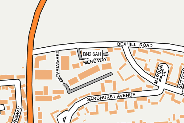
BN2 6AH lies on Hunns Mere Way in Brighton. BN2 6AH is located in the Woodingdean electoral ward, within the unitary authority of Brighton and Hove and the English Parliamentary constituency of Brighton, Kemptown. The Sub Integrated Care Board (ICB) Location is NHS Sussex ICB - 09D and the police force is Sussex. This postcode has been in use since June 2009.


GetTheData
Source: OS OpenMap – Local (Ordnance Survey)
Source: OS VectorMap District (Ordnance Survey)
Licence: Open Government Licence (requires attribution)
| Easting | 535819 |
| Northing | 106258 |
| Latitude | 50.839919 |
| Longitude | -0.072400 |
GetTheData
Source: Open Postcode Geo
Licence: Open Government Licence
| Street | Hunns Mere Way |
| Town/City | Brighton |
| Country | England |
| Postcode District | BN2 |
➜ See where BN2 is on a map ➜ Where is Brighton and Hove? | |
GetTheData
Source: Land Registry Price Paid Data
Licence: Open Government Licence
Elevation or altitude of BN2 6AH as distance above sea level:
| Metres | Feet | |
|---|---|---|
| Elevation | 150m | 492ft |
Elevation is measured from the approximate centre of the postcode, to the nearest point on an OS contour line from OS Terrain 50, which has contour spacing of ten vertical metres.
➜ How high above sea level am I? Find the elevation of your current position using your device's GPS.
GetTheData
Source: Open Postcode Elevation
Licence: Open Government Licence
| Ward | Woodingdean |
| Constituency | Brighton, Kemptown |
GetTheData
Source: ONS Postcode Database
Licence: Open Government Licence
| Sea View Way (Bexhill Road) | Woodingdean | 65m |
| Sea View Way (Bexhill Road) | Woodingdean | 70m |
| Langley Crescent West End (Langley Crescent) | Woodingdean | 106m |
| Langley Crescent West End (Langley Crescent) | Woodingdean | 126m |
| Mcwilliam Road (Falmer Road) | Woodingdean | 234m |
| Falmer Station | 2.7km |
| Moulsecoomb Station | 3.4km |
| London Road (Brighton) Station | 4.5km |
GetTheData
Source: NaPTAN
Licence: Open Government Licence
| Median download speed | 40.0Mbps |
| Average download speed | 44.2Mbps |
| Maximum download speed | 57.81Mbps |
| Median upload speed | 10.0Mbps |
| Average upload speed | 9.6Mbps |
| Maximum upload speed | 13.41Mbps |
GetTheData
Source: Ofcom
Licence: Ofcom Terms of Use (requires attribution)
Estimated total energy consumption in BN2 6AH by fuel type, 2015.
| Consumption (kWh) | 223,192 |
|---|---|
| Meter count | 16 |
| Mean (kWh/meter) | 13,950 |
| Median (kWh/meter) | 13,550 |
GetTheData
Source: Postcode level gas estimates: 2015 (experimental)
Source: Postcode level electricity estimates: 2015 (experimental)
Licence: Open Government Licence
GetTheData
Source: ONS Postcode Database
Licence: Open Government Licence

➜ Get more ratings from the Food Standards Agency
GetTheData
Source: Food Standards Agency
Licence: FSA terms & conditions
| Last Collection | |||
|---|---|---|---|
| Location | Mon-Fri | Sat | Distance |
| Balsdean Road No.1 | 16:30 | 11:15 | 225m |
| Langley Crescent | 16:30 | 10:30 | 274m |
| Woodingdean Post Office | 17:00 | 12:15 | 443m |
GetTheData
Source: Dracos
Licence: Creative Commons Attribution-ShareAlike
The below table lists the International Territorial Level (ITL) codes (formerly Nomenclature of Territorial Units for Statistics (NUTS) codes) and Local Administrative Units (LAU) codes for BN2 6AH:
| ITL 1 Code | Name |
|---|---|
| TLJ | South East (England) |
| ITL 2 Code | Name |
| TLJ2 | Surrey, East and West Sussex |
| ITL 3 Code | Name |
| TLJ21 | Brighton and Hove |
| LAU 1 Code | Name |
| E06000043 | Brighton and Hove |
GetTheData
Source: ONS Postcode Directory
Licence: Open Government Licence
The below table lists the Census Output Area (OA), Lower Layer Super Output Area (LSOA), and Middle Layer Super Output Area (MSOA) for BN2 6AH:
| Code | Name | |
|---|---|---|
| OA | E00085891 | |
| LSOA | E01017007 | Brighton and Hove 017A |
| MSOA | E02003507 | Brighton and Hove 017 |
GetTheData
Source: ONS Postcode Directory
Licence: Open Government Licence
| BN2 6NX | Sea View Way | 97m |
| BN2 6NF | Sandhurst Avenue | 103m |
| BN2 6NH | Langley Crescent | 142m |
| BN2 6NG | Sandhurst Avenue | 166m |
| BN2 6NJ | Marden Close | 245m |
| BN2 6NA | Falmer Road | 286m |
| BN2 6NN | Sutton Close | 287m |
| BN2 6PH | Warren Way | 291m |
| BN2 6PN | Spears Walk | 309m |
| BN2 6QA | Bexhill Road | 312m |
GetTheData
Source: Open Postcode Geo; Land Registry Price Paid Data
Licence: Open Government Licence