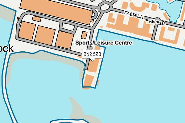
BN2 5ZB is located in the Whitehawk & Marina electoral ward, within the unitary authority of Brighton and Hove and the English Parliamentary constituency of Brighton, Kemptown. The Sub Integrated Care Board (ICB) Location is NHS Sussex ICB - 09D and the police force is Sussex. This postcode has been in use since May 2016.


GetTheData
Source: OS OpenMap – Local (Ordnance Survey)
Source: OS VectorMap District (Ordnance Survey)
Licence: Open Government Licence (requires attribution)
| Easting | 533672 |
| Northing | 103016 |
| Latitude | 50.811274 |
| Longitude | -0.104028 |
GetTheData
Source: Open Postcode Geo
Licence: Open Government Licence
| Country | England |
| Postcode District | BN2 |
➜ See where BN2 is on a map ➜ Where is Brighton? | |
GetTheData
Source: Land Registry Price Paid Data
Licence: Open Government Licence
Elevation or altitude of BN2 5ZB as distance above sea level:
| Metres | Feet | |
|---|---|---|
| Elevation | 10m | 33ft |
Elevation is measured from the approximate centre of the postcode, to the nearest point on an OS contour line from OS Terrain 50, which has contour spacing of ten vertical metres.
➜ How high above sea level am I? Find the elevation of your current position using your device's GPS.
GetTheData
Source: Open Postcode Elevation
Licence: Open Government Licence
| Ward | Whitehawk & Marina |
| Constituency | Brighton, Kemptown |
GetTheData
Source: ONS Postcode Database
Licence: Open Government Licence
| Marina Village (Brighton Marina) | Brighton | 88m |
| Marina Cinema (Marina Way) | Brighton | 162m |
| Seattle Hotel (The Strand) | Brighton | 222m |
| Marine Gate (Marine Drive) | Brighton | 376m |
| Marine Gate Flats (Marine Drive) | Brighton | 392m |
| Brighton Station | 3.3km |
| London Road (Brighton) Station | 3.6km |
| Moulsecoomb Station | 4.1km |
GetTheData
Source: NaPTAN
Licence: Open Government Licence
| Median download speed | 4.0Mbps |
| Average download speed | 3.8Mbps |
| Maximum download speed | 5.11Mbps |
| Median upload speed | 1.0Mbps |
| Average upload speed | 0.9Mbps |
| Maximum upload speed | 1.06Mbps |
GetTheData
Source: Ofcom
Licence: Ofcom Terms of Use (requires attribution)
GetTheData
Source: ONS Postcode Database
Licence: Open Government Licence


➜ Get more ratings from the Food Standards Agency
GetTheData
Source: Food Standards Agency
Licence: FSA terms & conditions
| Last Collection | |||
|---|---|---|---|
| Location | Mon-Fri | Sat | Distance |
| Arundel Terrace | 17:45 | 12:15 | 538m |
| Sussex Square | 16:00 | 11:30 | 822m |
| Rock Street | 17:45 | 13:00 | 834m |
GetTheData
Source: Dracos
Licence: Creative Commons Attribution-ShareAlike
| Risk of BN2 5ZB flooding from rivers and sea | High |
| ➜ BN2 5ZB flood map | |
GetTheData
Source: Open Flood Risk by Postcode
Licence: Open Government Licence
The below table lists the International Territorial Level (ITL) codes (formerly Nomenclature of Territorial Units for Statistics (NUTS) codes) and Local Administrative Units (LAU) codes for BN2 5ZB:
| ITL 1 Code | Name |
|---|---|
| TLJ | South East (England) |
| ITL 2 Code | Name |
| TLJ2 | Surrey, East and West Sussex |
| ITL 3 Code | Name |
| TLJ21 | Brighton and Hove |
| LAU 1 Code | Name |
| E06000043 | Brighton and Hove |
GetTheData
Source: ONS Postcode Directory
Licence: Open Government Licence
The below table lists the Census Output Area (OA), Lower Layer Super Output Area (LSOA), and Middle Layer Super Output Area (MSOA) for BN2 5ZB:
| Code | Name | |
|---|---|---|
| OA | E00085620 | |
| LSOA | E01016957 | Brighton and Hove 032C |
| MSOA | E02003522 | Brighton and Hove 032 |
GetTheData
Source: ONS Postcode Directory
Licence: Open Government Licence
| BN2 5UP | Western Concourse | 171m |
| BN2 5UW | 235m | |
| BN2 5SL | The Strand | 251m |
| BN2 5SN | The Strand | 251m |
| BN2 5UU | 271m | |
| BN2 5UX | 323m | |
| BN2 5UZ | 354m | |
| BN2 5XY | The Strand | 356m |
| BN2 5XZ | The Strand | 356m |
| BN2 5UY | Trafalgar Gate | 376m |
GetTheData
Source: Open Postcode Geo; Land Registry Price Paid Data
Licence: Open Government Licence