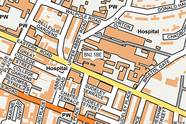
BN2 5BE is located in the Whitehawk & Marina electoral ward, within the unitary authority of Brighton and Hove and the English Parliamentary constituency of Brighton, Kemptown. The Sub Integrated Care Board (ICB) Location is NHS Sussex ICB - 09D and the police force is Sussex. This postcode has been in use since January 1980.


GetTheData
Source: OS OpenMap – Local (Ordnance Survey)
Source: OS VectorMap District (Ordnance Survey)
Licence: Open Government Licence (requires attribution)
| Easting | 532654 |
| Northing | 103901 |
| Latitude | 50.819468 |
| Longitude | -0.118177 |
GetTheData
Source: Open Postcode Geo
Licence: Open Government Licence
| Country | England |
| Postcode District | BN2 |
➜ See where BN2 is on a map ➜ Where is Brighton? | |
GetTheData
Source: Land Registry Price Paid Data
Licence: Open Government Licence
Elevation or altitude of BN2 5BE as distance above sea level:
| Metres | Feet | |
|---|---|---|
| Elevation | 50m | 164ft |
Elevation is measured from the approximate centre of the postcode, to the nearest point on an OS contour line from OS Terrain 50, which has contour spacing of ten vertical metres.
➜ How high above sea level am I? Find the elevation of your current position using your device's GPS.
GetTheData
Source: Open Postcode Elevation
Licence: Open Government Licence
| Ward | Whitehawk & Marina |
| Constituency | Brighton, Kemptown |
GetTheData
Source: ONS Postcode Database
Licence: Open Government Licence
| County Hospital (Eastern Road) | Kemp Town | 58m |
| County Hospital (Eastern Road) | Kemp Town | 69m |
| County Hospital (Eastern Road) | Kemp Town | 72m |
| Belle Vue Gardens | Brighton | 145m |
| County Hospital Rear Entrance (Walpole Road) | Bristol Estate | 166m |
| Brighton Station | 1.9km |
| London Road (Brighton) Station | 2.3km |
| Moulsecoomb Station | 3km |
GetTheData
Source: NaPTAN
Licence: Open Government Licence
| Median download speed | 8.0Mbps |
| Average download speed | 17.4Mbps |
| Maximum download speed | 80.00Mbps |
| Median upload speed | 1.1Mbps |
| Average upload speed | 3.3Mbps |
| Maximum upload speed | 20.00Mbps |
GetTheData
Source: Ofcom
Licence: Ofcom Terms of Use (requires attribution)
GetTheData
Source: ONS Postcode Database
Licence: Open Government Licence


➜ Get more ratings from the Food Standards Agency
GetTheData
Source: Food Standards Agency
Licence: FSA terms & conditions
| Last Collection | |||
|---|---|---|---|
| Location | Mon-Fri | Sat | Distance |
| R.s.c.h. | 17:45 | 10:30 | 36m |
| St Georges Road Post Office | 17:45 | 13:00 | 232m |
| Eaton Place | 17:45 | 13:00 | 235m |
GetTheData
Source: Dracos
Licence: Creative Commons Attribution-ShareAlike
The below table lists the International Territorial Level (ITL) codes (formerly Nomenclature of Territorial Units for Statistics (NUTS) codes) and Local Administrative Units (LAU) codes for BN2 5BE:
| ITL 1 Code | Name |
|---|---|
| TLJ | South East (England) |
| ITL 2 Code | Name |
| TLJ2 | Surrey, East and West Sussex |
| ITL 3 Code | Name |
| TLJ21 | Brighton and Hove |
| LAU 1 Code | Name |
| E06000043 | Brighton and Hove |
GetTheData
Source: ONS Postcode Directory
Licence: Open Government Licence
The below table lists the Census Output Area (OA), Lower Layer Super Output Area (LSOA), and Middle Layer Super Output Area (MSOA) for BN2 5BE:
| Code | Name | |
|---|---|---|
| OA | E00085099 | |
| LSOA | E01016862 | Brighton and Hove 031B |
| MSOA | E02003521 | Brighton and Hove 031 |
GetTheData
Source: ONS Postcode Directory
Licence: Open Government Licence
| BN2 1HS | Abbey Road | 105m |
| BN2 1HU | Chapel Terrace Mews | 105m |
| BN2 0AD | Upper Abbey Road | 109m |
| BN2 1HD | Sudeley Terrace | 113m |
| BN2 1HA | Paston Place | 121m |
| BN2 1HB | Chapel Terrace | 133m |
| BN2 5BA | Eastern Road | 133m |
| BN2 1HH | Upper Sudeley Street | 141m |
| BN2 0AG | Eastern Road | 151m |
| BN2 1FU | St Georges Road | 151m |
GetTheData
Source: Open Postcode Geo; Land Registry Price Paid Data
Licence: Open Government Licence