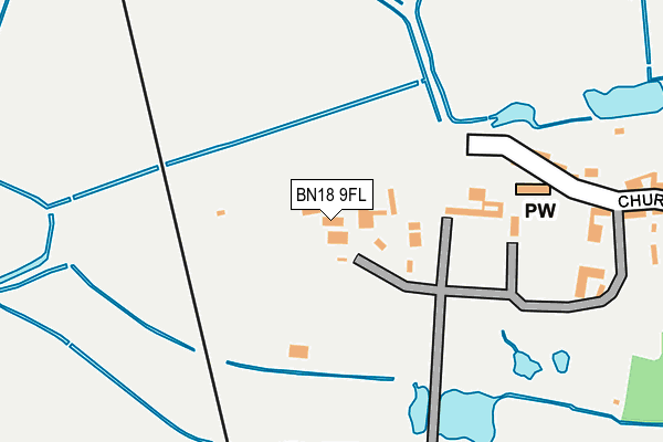
BN18 9FL is located in the Pulborough, Coldwaltham & Amberley electoral ward, within the local authority district of Horsham and the English Parliamentary constituency of Arundel and South Downs. The Sub Integrated Care Board (ICB) Location is NHS Sussex ICB - 70F and the police force is Sussex. This postcode has been in use since May 2017.


GetTheData
Source: OS OpenMap – Local (Ordnance Survey)
Source: OS VectorMap District (Ordnance Survey)
Licence: Open Government Licence (requires attribution)
| Easting | 502606 |
| Northing | 113164 |
| Latitude | 50.908829 |
| Longitude | -0.541960 |
GetTheData
Source: Open Postcode Geo
Licence: Open Government Licence
| Country | England |
| Postcode District | BN18 |
➜ See where BN18 is on a map ➜ Where is Amberley? | |
GetTheData
Source: Land Registry Price Paid Data
Licence: Open Government Licence
| Ward | Pulborough, Coldwaltham & Amberley |
| Constituency | Arundel And South Downs |
GetTheData
Source: ONS Postcode Database
Licence: Open Government Licence
| High Street (Church Street) | Amberley | 548m |
| Primary School (School Road) | Amberley | 555m |
| Primary School (School Road) | Amberley | 562m |
| Mill Road (New Barn Road) | Amberley | 597m |
| High Titten (New Barn Road) | Amberley | 655m |
| Amberley Station | 1.4km |
GetTheData
Source: NaPTAN
Licence: Open Government Licence
| Percentage of properties with Next Generation Access | 100.0% |
| Percentage of properties with Superfast Broadband | 100.0% |
| Percentage of properties with Ultrafast Broadband | 0.0% |
| Percentage of properties with Full Fibre Broadband | 0.0% |
Superfast Broadband is between 30Mbps and 300Mbps
Ultrafast Broadband is > 300Mbps
| Percentage of properties unable to receive 2Mbps | 0.0% |
| Percentage of properties unable to receive 5Mbps | 0.0% |
| Percentage of properties unable to receive 10Mbps | 0.0% |
| Percentage of properties unable to receive 30Mbps | 0.0% |
GetTheData
Source: Ofcom
Licence: Ofcom Terms of Use (requires attribution)
GetTheData
Source: ONS Postcode Database
Licence: Open Government Licence


➜ Get more ratings from the Food Standards Agency
GetTheData
Source: Food Standards Agency
Licence: FSA terms & conditions
| Last Collection | |||
|---|---|---|---|
| Location | Mon-Fri | Sat | Distance |
| Amberley Church Street | 16:00 | 09:00 | 241m |
| Amberley Post Office | 16:00 | 10:00 | 540m |
| Amberley Museum | 16:00 | 08:00 | 1,229m |
GetTheData
Source: Dracos
Licence: Creative Commons Attribution-ShareAlike
The below table lists the International Territorial Level (ITL) codes (formerly Nomenclature of Territorial Units for Statistics (NUTS) codes) and Local Administrative Units (LAU) codes for BN18 9FL:
| ITL 1 Code | Name |
|---|---|
| TLJ | South East (England) |
| ITL 2 Code | Name |
| TLJ2 | Surrey, East and West Sussex |
| ITL 3 Code | Name |
| TLJ28 | West Sussex (North East) |
| LAU 1 Code | Name |
| E07000227 | Horsham |
GetTheData
Source: ONS Postcode Directory
Licence: Open Government Licence
The below table lists the Census Output Area (OA), Lower Layer Super Output Area (LSOA), and Middle Layer Super Output Area (MSOA) for BN18 9FL:
| Code | Name | |
|---|---|---|
| OA | E00161282 | |
| LSOA | E01031626 | Horsham 013A |
| MSOA | E02006600 | Horsham 013 |
GetTheData
Source: ONS Postcode Directory
Licence: Open Government Licence
| BN18 9NF | Church Street | 273m |
| BN18 9NG | The Alley | 351m |
| BN18 9ND | Church Street | 384m |
| BN18 9NQ | Hog Lane | 440m |
| BN18 9NE | Church Street | 464m |
| BN18 9NH | Hog Lane | 467m |
| BN18 9NJ | High Street | 537m |
| BN18 9NA | School Road | 548m |
| BN18 9SR | The Square | 568m |
| BN18 9NL | High Street | 599m |
GetTheData
Source: Open Postcode Geo; Land Registry Price Paid Data
Licence: Open Government Licence