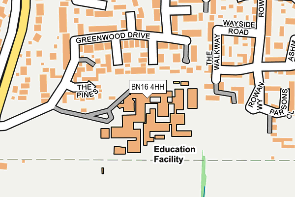
BN16 4HH is located in the Angmering & Findon electoral ward, within the local authority district of Arun and the English Parliamentary constituency of Arundel and South Downs. The Sub Integrated Care Board (ICB) Location is NHS Sussex ICB - 70F and the police force is Sussex. This postcode has been in use since January 1980.


GetTheData
Source: OS OpenMap – Local (Ordnance Survey)
Source: OS VectorMap District (Ordnance Survey)
Licence: Open Government Licence (requires attribution)
| Easting | 506898 |
| Northing | 103538 |
| Latitude | 50.821528 |
| Longitude | -0.483768 |
GetTheData
Source: Open Postcode Geo
Licence: Open Government Licence
| Country | England |
| Postcode District | BN16 |
➜ See where BN16 is on a map ➜ Where is Angmering? | |
GetTheData
Source: Land Registry Price Paid Data
Licence: Open Government Licence
Elevation or altitude of BN16 4HH as distance above sea level:
| Metres | Feet | |
|---|---|---|
| Elevation | 10m | 33ft |
Elevation is measured from the approximate centre of the postcode, to the nearest point on an OS contour line from OS Terrain 50, which has contour spacing of ten vertical metres.
➜ How high above sea level am I? Find the elevation of your current position using your device's GPS.
GetTheData
Source: Open Postcode Elevation
Licence: Open Government Licence
| Ward | Angmering & Findon |
| Constituency | Arundel And South Downs |
GetTheData
Source: ONS Postcode Database
Licence: Open Government Licence
| Angmering School (Greenwood Drive) | Angmering | 129m |
| Rowan Way | Angmering | 211m |
| North Drive (Station Road) | Angmering | 280m |
| North Drive (Station Road) | Angmering | 297m |
| Dell Drive (Station Road) | Angmering | 479m |
| Angmering Station | 0.7km |
| Goring-by-Sea Station | 3.6km |
| Littlehampton Station | 4.6km |
GetTheData
Source: NaPTAN
Licence: Open Government Licence
GetTheData
Source: ONS Postcode Database
Licence: Open Government Licence


➜ Get more ratings from the Food Standards Agency
GetTheData
Source: Food Standards Agency
Licence: FSA terms & conditions
| Last Collection | |||
|---|---|---|---|
| Location | Mon-Fri | Sat | Distance |
| Bentley Close | 17:00 | 12:15 | 552m |
| Warren Crescent | 16:40 | 11:15 | 675m |
| Downsway | 16:30 | 11:15 | 727m |
GetTheData
Source: Dracos
Licence: Creative Commons Attribution-ShareAlike
The below table lists the International Territorial Level (ITL) codes (formerly Nomenclature of Territorial Units for Statistics (NUTS) codes) and Local Administrative Units (LAU) codes for BN16 4HH:
| ITL 1 Code | Name |
|---|---|
| TLJ | South East (England) |
| ITL 2 Code | Name |
| TLJ2 | Surrey, East and West Sussex |
| ITL 3 Code | Name |
| TLJ27 | West Sussex (South West) |
| LAU 1 Code | Name |
| E07000224 | Arun |
GetTheData
Source: ONS Postcode Directory
Licence: Open Government Licence
The below table lists the Census Output Area (OA), Lower Layer Super Output Area (LSOA), and Middle Layer Super Output Area (MSOA) for BN16 4HH:
| Code | Name | |
|---|---|---|
| OA | E00172649 | |
| LSOA | E01031388 | Arun 005A |
| MSOA | E02006546 | Arun 005 |
GetTheData
Source: ONS Postcode Directory
Licence: Open Government Licence
| BN16 4EZ | Maytree Close | 78m |
| BN16 4NF | Chestnut Close | 88m |
| BN16 4NE | Acorn Close | 96m |
| BN16 4NG | The Pines | 122m |
| BN16 4ND | Greenwood Drive | 135m |
| BN16 4BA | Willow Wood Close | 152m |
| BN16 4DL | Sycamore Close | 159m |
| BN16 4JW | Greenwood Drive | 170m |
| BN16 4BF | The Walkway | 180m |
| BN16 4DZ | Ashdown Close | 216m |
GetTheData
Source: Open Postcode Geo; Land Registry Price Paid Data
Licence: Open Government Licence