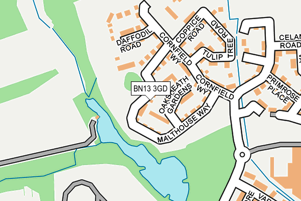
BN13 3GD is located in the Northbrook electoral ward, within the local authority district of Worthing and the English Parliamentary constituency of Worthing West. The Sub Integrated Care Board (ICB) Location is NHS Sussex ICB - 70F and the police force is Sussex. This postcode has been in use since May 2016.


GetTheData
Source: OS OpenMap – Local (Ordnance Survey)
Source: OS VectorMap District (Ordnance Survey)
Licence: Open Government Licence (requires attribution)
| Easting | 510602 |
| Northing | 104939 |
| Latitude | 50.833419 |
| Longitude | -0.430757 |
GetTheData
Source: Open Postcode Geo
Licence: Open Government Licence
| Country | England |
| Postcode District | BN13 |
➜ See where BN13 is on a map ➜ Where is Worthing? | |
GetTheData
Source: Land Registry Price Paid Data
Licence: Open Government Licence
Elevation or altitude of BN13 3GD as distance above sea level:
| Metres | Feet | |
|---|---|---|
| Elevation | 20m | 66ft |
Elevation is measured from the approximate centre of the postcode, to the nearest point on an OS contour line from OS Terrain 50, which has contour spacing of ten vertical metres.
➜ How high above sea level am I? Find the elevation of your current position using your device's GPS.
GetTheData
Source: Open Postcode Elevation
Licence: Open Government Licence
| Ward | Northbrook |
| Constituency | Worthing West |
GetTheData
Source: ONS Postcode Database
Licence: Open Government Licence
2022 8 APR £415,000 |
2020 10 AUG £360,000 |
56, MALTHOUSE WAY, WORTHING, BN13 3GD 2016 16 DEC £355,000 |
48, MALTHOUSE WAY, WORTHING, BN13 3GD 2016 16 DEC £330,000 |
52, MALTHOUSE WAY, WORTHING, BN13 3GD 2016 16 DEC £430,000 |
2016 14 DEC £333,500 |
22, MALTHOUSE WAY, WORTHING, BN13 3GD 2016 14 OCT £322,500 |
20, MALTHOUSE WAY, WORTHING, BN13 3GD 2016 30 JUN £310,000 |
16, MALTHOUSE WAY, WORTHING, BN13 3GD 2016 17 MAY £350,000 |
10, MALTHOUSE WAY, WORTHING, BN13 3GD 2016 9 MAY £399,000 |
GetTheData
Source: HM Land Registry Price Paid Data
Licence: Contains HM Land Registry data © Crown copyright and database right 2025. This data is licensed under the Open Government Licence v3.0.
| Orkney Court (Carisbrooke Drive) | Durrington | 520m |
| Batemans Close (Romany Road) | Durrington | 632m |
| Leeds Close (Carisbrooke Drive) | Durrington | 642m |
| Torridge Close (New Road) | Durrington | 657m |
| Torridge Close (New Road) | Durrington | 670m |
| Goring-by-Sea Station | 1.8km |
| Durrington-on-Sea Station | 2.2km |
| West Worthing Station | 3.1km |
GetTheData
Source: NaPTAN
Licence: Open Government Licence
| Percentage of properties with Next Generation Access | 100.0% |
| Percentage of properties with Superfast Broadband | 100.0% |
| Percentage of properties with Ultrafast Broadband | 100.0% |
| Percentage of properties with Full Fibre Broadband | 100.0% |
Superfast Broadband is between 30Mbps and 300Mbps
Ultrafast Broadband is > 300Mbps
| Median download speed | 360.0Mbps |
| Average download speed | 360.0Mbps |
| Maximum download speed | 360.00Mbps |
| Median upload speed | 360.0Mbps |
| Average upload speed | 360.0Mbps |
| Maximum upload speed | 360.00Mbps |
| Percentage of properties unable to receive 2Mbps | 0.0% |
| Percentage of properties unable to receive 5Mbps | 0.0% |
| Percentage of properties unable to receive 10Mbps | 0.0% |
| Percentage of properties unable to receive 30Mbps | 0.0% |
GetTheData
Source: Ofcom
Licence: Ofcom Terms of Use (requires attribution)
GetTheData
Source: ONS Postcode Database
Licence: Open Government Licence


➜ Get more ratings from the Food Standards Agency
GetTheData
Source: Food Standards Agency
Licence: FSA terms & conditions
| Last Collection | |||
|---|---|---|---|
| Location | Mon-Fri | Sat | Distance |
| Tesco | 18:00 | 11:30 | 426m |
| Buckingham Road | 18:00 | 12:15 | 921m |
| Adur Avenue | 16:30 | 11:30 | 1,093m |
GetTheData
Source: Dracos
Licence: Creative Commons Attribution-ShareAlike
The below table lists the International Territorial Level (ITL) codes (formerly Nomenclature of Territorial Units for Statistics (NUTS) codes) and Local Administrative Units (LAU) codes for BN13 3GD:
| ITL 1 Code | Name |
|---|---|
| TLJ | South East (England) |
| ITL 2 Code | Name |
| TLJ2 | Surrey, East and West Sussex |
| ITL 3 Code | Name |
| TLJ27 | West Sussex (South West) |
| LAU 1 Code | Name |
| E07000229 | Worthing |
GetTheData
Source: ONS Postcode Directory
Licence: Open Government Licence
The below table lists the Census Output Area (OA), Lower Layer Super Output Area (LSOA), and Middle Layer Super Output Area (MSOA) for BN13 3GD:
| Code | Name | |
|---|---|---|
| OA | E00162255 | |
| LSOA | E01031819 | Worthing 006E |
| MSOA | E02006626 | Worthing 006 |
GetTheData
Source: ONS Postcode Directory
Licence: Open Government Licence
| BN13 3ST | Rees Close | 307m |
| BN13 3SP | Callon Close | 315m |
| BN13 3SN | Varey Road | 335m |
| BN13 3SL | Squadron Drive | 364m |
| BN13 3SW | Essenhigh Drive | 409m |
| BN13 3FD | Forest Barn Mews | 426m |
| BN13 3RP | Rochester Close | 448m |
| BN13 3RH | Eriskay Court | 458m |
| BN13 3HL | Hobart Close | 464m |
| BN13 3SR | Thomson Close | 465m |
GetTheData
Source: Open Postcode Geo; Land Registry Price Paid Data
Licence: Open Government Licence