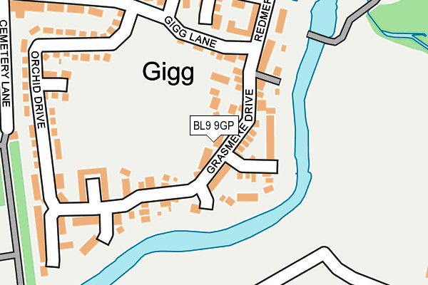
BL9 9GP lies on Grasmere Drive in Bury. BL9 9GP is located in the Redvales electoral ward, within the metropolitan district of Bury and the English Parliamentary constituency of Bury North. The Sub Integrated Care Board (ICB) Location is NHS Greater Manchester ICB - 00V and the police force is Greater Manchester. This postcode has been in use since February 2005.


GetTheData
Source: OS OpenMap – Local (Ordnance Survey)
Source: OS VectorMap District (Ordnance Survey)
Licence: Open Government Licence (requires attribution)
| Easting | 381302 |
| Northing | 409382 |
| Latitude | 53.580693 |
| Longitude | -2.283884 |
GetTheData
Source: Open Postcode Geo
Licence: Open Government Licence
| Street | Grasmere Drive |
| Town/City | Bury |
| Country | England |
| Postcode District | BL9 |
➜ See where BL9 is on a map ➜ Where is Bury? | |
GetTheData
Source: Land Registry Price Paid Data
Licence: Open Government Licence
Elevation or altitude of BL9 9GP as distance above sea level:
| Metres | Feet | |
|---|---|---|
| Elevation | 70m | 230ft |
Elevation is measured from the approximate centre of the postcode, to the nearest point on an OS contour line from OS Terrain 50, which has contour spacing of ten vertical metres.
➜ How high above sea level am I? Find the elevation of your current position using your device's GPS.
GetTheData
Source: Open Postcode Elevation
Licence: Open Government Licence
| Ward | Redvales |
| Constituency | Bury North |
GetTheData
Source: ONS Postcode Database
Licence: Open Government Licence
| Cornwall Dr/Rutland Dr (Cornwall Dr) | Fishpool | 407m |
| Cornwall Dr/Rutland Dr (Cornwall Dr) | Fishpool | 430m |
| Cornwall Dr/Sussex Dr (Cornwall Dr) | Fishpool | 527m |
| Cornwall Dr/Market St (Cornwall Dr) | Fishpool | 532m |
| Bridges Avenue | Fletcher Fold | 607m |
| Bury (Manchester Metrolink) (The Haymarket) | Bury | 1,439m |
| Bury Bolton Street (East Lancashire Railway) | Bury | 1,773m |
GetTheData
Source: NaPTAN
Licence: Open Government Licence
| Median download speed | 36.2Mbps |
| Average download speed | 27.2Mbps |
| Maximum download speed | 54.63Mbps |
| Median upload speed | 7.7Mbps |
| Average upload speed | 6.2Mbps |
| Maximum upload speed | 14.59Mbps |
GetTheData
Source: Ofcom
Licence: Ofcom Terms of Use (requires attribution)
Estimated total energy consumption in BL9 9GP by fuel type, 2015.
| Consumption (kWh) | 27,576 |
|---|---|
| Meter count | 12 |
| Mean (kWh/meter) | 2,298 |
| Median (kWh/meter) | 2,196 |
GetTheData
Source: Postcode level gas estimates: 2015 (experimental)
Source: Postcode level electricity estimates: 2015 (experimental)
Licence: Open Government Licence
GetTheData
Source: ONS Postcode Database
Licence: Open Government Licence

➜ Get more ratings from the Food Standards Agency
GetTheData
Source: Food Standards Agency
Licence: FSA terms & conditions
| Last Collection | |||
|---|---|---|---|
| Location | Mon-Fri | Sat | Distance |
| Fishpool P O | 18:30 | 11:20 | 197m |
| 126 Parkhills Road | 17:20 | 10:50 | 721m |
| Houghton Street | 17:40 | 11:10 | 732m |
GetTheData
Source: Dracos
Licence: Creative Commons Attribution-ShareAlike
The below table lists the International Territorial Level (ITL) codes (formerly Nomenclature of Territorial Units for Statistics (NUTS) codes) and Local Administrative Units (LAU) codes for BL9 9GP:
| ITL 1 Code | Name |
|---|---|
| TLD | North West (England) |
| ITL 2 Code | Name |
| TLD3 | Greater Manchester |
| ITL 3 Code | Name |
| TLD37 | Greater Manchester North East |
| LAU 1 Code | Name |
| E08000002 | Bury |
GetTheData
Source: ONS Postcode Directory
Licence: Open Government Licence
The below table lists the Census Output Area (OA), Lower Layer Super Output Area (LSOA), and Middle Layer Super Output Area (MSOA) for BL9 9GP:
| Code | Name | |
|---|---|---|
| OA | E00171710 | |
| LSOA | E01005059 | Bury 013C |
| MSOA | E02001031 | Bury 013 |
GetTheData
Source: ONS Postcode Directory
Licence: Open Government Licence
| BL9 9GF | Arncliffe Close | 61m |
| BL9 9GG | Newby Close | 78m |
| BL9 9GH | Harrington Close | 78m |
| BL9 9GA | Grasmere Drive | 85m |
| BL9 9GJ | Kingsdale Close | 165m |
| BL9 9GL | Garsdale Close | 194m |
| BL9 9GB | Redmere Drive | 195m |
| BL9 9GE | Silverdale Close | 203m |
| BL9 9HA | Gigg Lane | 211m |
| BL9 9EW | Gigg Lane | 242m |
GetTheData
Source: Open Postcode Geo; Land Registry Price Paid Data
Licence: Open Government Licence