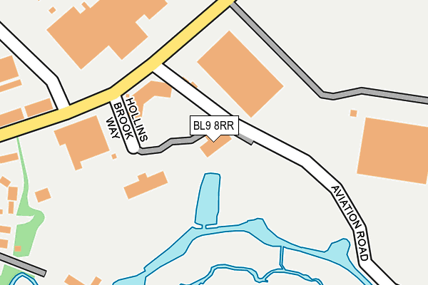
BL9 8RR is located in the Unsworth electoral ward, within the metropolitan district of Bury and the English Parliamentary constituency of Bury South. The Sub Integrated Care Board (ICB) Location is NHS Greater Manchester ICB - 00V and the police force is Greater Manchester. This postcode has been in use since June 2000.


GetTheData
Source: OS OpenMap – Local (Ordnance Survey)
Source: OS VectorMap District (Ordnance Survey)
Licence: Open Government Licence (requires attribution)
| Easting | 381627 |
| Northing | 408624 |
| Latitude | 53.573908 |
| Longitude | -2.278928 |
GetTheData
Source: Open Postcode Geo
Licence: Open Government Licence
| Country | England |
| Postcode District | BL9 |
➜ See where BL9 is on a map ➜ Where is Bury? | |
GetTheData
Source: Land Registry Price Paid Data
Licence: Open Government Licence
Elevation or altitude of BL9 8RR as distance above sea level:
| Metres | Feet | |
|---|---|---|
| Elevation | 80m | 262ft |
Elevation is measured from the approximate centre of the postcode, to the nearest point on an OS contour line from OS Terrain 50, which has contour spacing of ten vertical metres.
➜ How high above sea level am I? Find the elevation of your current position using your device's GPS.
GetTheData
Source: Open Postcode Elevation
Licence: Open Government Licence
| Ward | Unsworth |
| Constituency | Bury South |
GetTheData
Source: ONS Postcode Database
Licence: Open Government Licence
| Pilsworth Rd/Aviation Rd (Pilsworth Rd) | Pilsworth | 155m |
| Pilsworth Rd/Pilsworth Way (Pilsworth Rd) | Pilsworth | 185m |
| Croft Ln/The Croft (Croft Ln) | Pilsworth | 305m |
| Croft Ln/Borden Way (Croft Ln) | Pilsworth | 318m |
| Roach Bank Rd/Asda (Roach Bank Rd) | Pilsworth | 427m |
GetTheData
Source: NaPTAN
Licence: Open Government Licence
GetTheData
Source: ONS Postcode Database
Licence: Open Government Licence


➜ Get more ratings from the Food Standards Agency
GetTheData
Source: Food Standards Agency
Licence: FSA terms & conditions
| Last Collection | |||
|---|---|---|---|
| Location | Mon-Fri | Sat | Distance |
| Fishpool P O | 18:30 | 11:20 | 989m |
| 126 Parkhills Road | 17:20 | 10:50 | 1,514m |
| Houghton Street | 17:40 | 11:10 | 1,544m |
GetTheData
Source: Dracos
Licence: Creative Commons Attribution-ShareAlike
The below table lists the International Territorial Level (ITL) codes (formerly Nomenclature of Territorial Units for Statistics (NUTS) codes) and Local Administrative Units (LAU) codes for BL9 8RR:
| ITL 1 Code | Name |
|---|---|
| TLD | North West (England) |
| ITL 2 Code | Name |
| TLD3 | Greater Manchester |
| ITL 3 Code | Name |
| TLD37 | Greater Manchester North East |
| LAU 1 Code | Name |
| E08000002 | Bury |
GetTheData
Source: ONS Postcode Directory
Licence: Open Government Licence
The below table lists the Census Output Area (OA), Lower Layer Super Output Area (LSOA), and Middle Layer Super Output Area (MSOA) for BL9 8RR:
| Code | Name | |
|---|---|---|
| OA | E00025586 | |
| LSOA | E01005054 | Bury 013B |
| MSOA | E02001031 | Bury 013 |
GetTheData
Source: ONS Postcode Directory
Licence: Open Government Licence
| BL9 8RP | Pilsworth Road | 198m |
| BL9 8RL | The Croft | 226m |
| BL9 8QF | Borden Way | 279m |
| BL9 8QH | Croft Lane | 409m |
| BL9 8BW | Balmoral Close | 472m |
| BL9 8BP | Haddon Close | 476m |
| BL9 8BN | Alton Close | 538m |
| BL9 8BE | Melton Drive | 572m |
| BL9 8LT | Haweswater Crescent | 574m |
| BL9 8PZ | Hollins Brook Close | 576m |
GetTheData
Source: Open Postcode Geo; Land Registry Price Paid Data
Licence: Open Government Licence