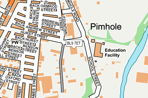
BL9 7ET is located in the Bury East electoral ward, within the metropolitan district of Bury and the English Parliamentary constituency of Bury North. The Sub Integrated Care Board (ICB) Location is NHS Greater Manchester ICB - 00V and the police force is Greater Manchester. This postcode has been in use since June 2000.


GetTheData
Source: OS OpenMap – Local (Ordnance Survey)
Source: OS VectorMap District (Ordnance Survey)
Licence: Open Government Licence (requires attribution)
| Easting | 381407 |
| Northing | 410363 |
| Latitude | 53.589530 |
| Longitude | -2.282354 |
GetTheData
Source: Open Postcode Geo
Licence: Open Government Licence
| Country | England |
| Postcode District | BL9 |
➜ See where BL9 is on a map ➜ Where is Bury? | |
GetTheData
Source: Land Registry Price Paid Data
Licence: Open Government Licence
Elevation or altitude of BL9 7ET as distance above sea level:
| Metres | Feet | |
|---|---|---|
| Elevation | 90m | 295ft |
Elevation is measured from the approximate centre of the postcode, to the nearest point on an OS contour line from OS Terrain 50, which has contour spacing of ten vertical metres.
➜ How high above sea level am I? Find the elevation of your current position using your device's GPS.
GetTheData
Source: Open Postcode Elevation
Licence: Open Government Licence
| Ward | Bury East |
| Constituency | Bury North |
GetTheData
Source: ONS Postcode Database
Licence: Open Government Licence
| Heywood St/Hurst St (Heywood St) | Bury | 310m |
| Heywood St/Hacking St (Heywood St) | Bury | 329m |
| Rochdale Rd/Pimhole Rd (Rochdale Rd) | Bury | 354m |
| Heywood St/Shepherd St (Heywood St) | Bury | 359m |
| Rochdale Rd/Roach Hotel (Rochdale Rd) | Bury | 369m |
| Bury (Manchester Metrolink) (The Haymarket) | Bury | 990m |
| Bury Bolton Street (East Lancashire Railway) | Bury | 1,233m |
GetTheData
Source: NaPTAN
Licence: Open Government Licence
| Median download speed | 14.3Mbps |
| Average download speed | 25.5Mbps |
| Maximum download speed | 80.00Mbps |
| Median upload speed | 1.1Mbps |
| Average upload speed | 4.3Mbps |
| Maximum upload speed | 20.00Mbps |
GetTheData
Source: Ofcom
Licence: Ofcom Terms of Use (requires attribution)
GetTheData
Source: ONS Postcode Database
Licence: Open Government Licence


➜ Get more ratings from the Food Standards Agency
GetTheData
Source: Food Standards Agency
Licence: FSA terms & conditions
| Last Collection | |||
|---|---|---|---|
| Location | Mon-Fri | Sat | Distance |
| Houghton Street | 17:40 | 11:10 | 330m |
| 126 Parkhills Road | 17:20 | 10:50 | 795m |
| Fishpool P O | 18:30 | 11:20 | 926m |
GetTheData
Source: Dracos
Licence: Creative Commons Attribution-ShareAlike
The below table lists the International Territorial Level (ITL) codes (formerly Nomenclature of Territorial Units for Statistics (NUTS) codes) and Local Administrative Units (LAU) codes for BL9 7ET:
| ITL 1 Code | Name |
|---|---|
| TLD | North West (England) |
| ITL 2 Code | Name |
| TLD3 | Greater Manchester |
| ITL 3 Code | Name |
| TLD37 | Greater Manchester North East |
| LAU 1 Code | Name |
| E08000002 | Bury |
GetTheData
Source: ONS Postcode Directory
Licence: Open Government Licence
The below table lists the Census Output Area (OA), Lower Layer Super Output Area (LSOA), and Middle Layer Super Output Area (MSOA) for BL9 7ET:
| Code | Name | |
|---|---|---|
| OA | E00171709 | |
| LSOA | E01005026 | Bury 008F |
| MSOA | E02001026 | Bury 008 |
GetTheData
Source: ONS Postcode Directory
Licence: Open Government Licence
| BL9 7EG | James Street | 150m |
| BL9 7ES | Hurst Street | 154m |
| BL9 7HB | Andrew Street | 178m |
| BL9 7EX | Primrose Court | 186m |
| BL9 7EJ | Alfred Street | 191m |
| BL9 7EP | Benson Street | 196m |
| BL9 7EW | Nuttall Street | 205m |
| BL9 7EL | Oxford Street | 209m |
| BL9 7HQ | Palace Street | 224m |
| BL9 7ER | Hurst Street | 233m |
GetTheData
Source: Open Postcode Geo; Land Registry Price Paid Data
Licence: Open Government Licence