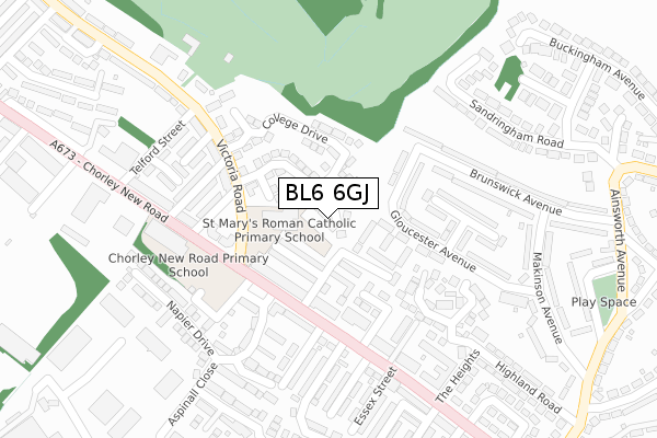
BL6 6GJ is located in the Horwich North electoral ward, within the metropolitan district of Bolton and the English Parliamentary constituency of Bolton West. The Sub Integrated Care Board (ICB) Location is NHS Greater Manchester ICB - 00T and the police force is Greater Manchester. This postcode has been in use since November 2019.


GetTheData
Source: OS Open Zoomstack (Ordnance Survey)
Licence: Open Government Licence (requires attribution)
Attribution: Contains OS data © Crown copyright and database right 2024
Source: Open Postcode Geo
Licence: Open Government Licence (requires attribution)
Attribution: Contains OS data © Crown copyright and database right 2024; Contains Royal Mail data © Royal Mail copyright and database right 2024; Source: Office for National Statistics licensed under the Open Government Licence v.3.0
| Easting | 364761 |
| Northing | 410603 |
| Latitude | 53.590829 |
| Longitude | -2.533845 |
GetTheData
Source: Open Postcode Geo
Licence: Open Government Licence
| Country | England |
| Postcode District | BL6 |
➜ See where BL6 is on a map ➜ Where is Horwich? | |
GetTheData
Source: Land Registry Price Paid Data
Licence: Open Government Licence
| Ward | Horwich North |
| Constituency | Bolton West |
GetTheData
Source: ONS Postcode Database
Licence: Open Government Licence
| Victoria Rd/St Mary's (Victoria Rd) | Horwich | 128m |
| Chorley New Rd/Mount Street (Chorley New Rd) | Horwich | 134m |
| Victoria Rd/Primary Sch (Victoria Rd) | Horwich | 136m |
| Gloucester Avenue/Lancaster Avenue (Gloucester Ave) | Horwich | 143m |
| Gloucester Avenue/Lancaster Avenue (Gloucester Ave) | Horwich | 145m |
| Horwich Parkway Station | 1.5km |
| Blackrod Station | 2.4km |
| Lostock Station | 3.3km |
GetTheData
Source: NaPTAN
Licence: Open Government Licence
GetTheData
Source: ONS Postcode Database
Licence: Open Government Licence


➜ Get more ratings from the Food Standards Agency
GetTheData
Source: Food Standards Agency
Licence: FSA terms & conditions
| Last Collection | |||
|---|---|---|---|
| Location | Mon-Fri | Sat | Distance |
| Lower Brazeley P O | 17:15 | 12:10 | 164m |
| Winter Hey Lane P O | 18:45 | 12:05 | 1,283m |
| Chapel Lane Post Office | 17:00 | 11:15 | 1,354m |
GetTheData
Source: Dracos
Licence: Creative Commons Attribution-ShareAlike
The below table lists the International Territorial Level (ITL) codes (formerly Nomenclature of Territorial Units for Statistics (NUTS) codes) and Local Administrative Units (LAU) codes for BL6 6GJ:
| ITL 1 Code | Name |
|---|---|
| TLD | North West (England) |
| ITL 2 Code | Name |
| TLD3 | Greater Manchester |
| ITL 3 Code | Name |
| TLD36 | Greater Manchester North West |
| LAU 1 Code | Name |
| E08000001 | Bolton |
GetTheData
Source: ONS Postcode Directory
Licence: Open Government Licence
The below table lists the Census Output Area (OA), Lower Layer Super Output Area (LSOA), and Middle Layer Super Output Area (MSOA) for BL6 6GJ:
| Code | Name | |
|---|---|---|
| OA | E00024707 | |
| LSOA | E01004883 | Bolton 007D |
| MSOA | E02000990 | Bolton 007 |
GetTheData
Source: ONS Postcode Directory
Licence: Open Government Licence
| BL6 6JX | Craven Street East | 83m |
| BL6 6JY | Dale Street East | 89m |
| BL6 6JU | Dale Street West | 91m |
| BL6 6PA | Gloucester Court | 97m |
| BL6 6PB | Craven Court | 102m |
| BL6 6JT | Chorley New Road | 115m |
| BL6 6DX | Mulberry Court | 117m |
| BL6 6NH | Gloucester Avenue | 126m |
| BL6 6JZ | Chorley New Road | 144m |
| BL6 6FY | Abernethy Street | 155m |
GetTheData
Source: Open Postcode Geo; Land Registry Price Paid Data
Licence: Open Government Licence