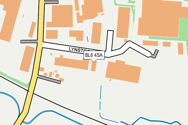
BL6 4SA is located in the Horwich South & Blackrod electoral ward, within the metropolitan district of Bolton and the English Parliamentary constituency of Bolton West. The Sub Integrated Care Board (ICB) Location is NHS Greater Manchester ICB - 00T and the police force is Greater Manchester. This postcode has been in use since June 1981.


GetTheData
Source: OS OpenMap – Local (Ordnance Survey)
Source: OS VectorMap District (Ordnance Survey)
Licence: Open Government Licence (requires attribution)
| Easting | 365381 |
| Northing | 408831 |
| Latitude | 53.574928 |
| Longitude | -2.524282 |
GetTheData
Source: Open Postcode Geo
Licence: Open Government Licence
| Country | England |
| Postcode District | BL6 |
➜ See where BL6 is on a map ➜ Where is Horwich? | |
GetTheData
Source: Land Registry Price Paid Data
Licence: Open Government Licence
Elevation or altitude of BL6 4SA as distance above sea level:
| Metres | Feet | |
|---|---|---|
| Elevation | 110m | 361ft |
Elevation is measured from the approximate centre of the postcode, to the nearest point on an OS contour line from OS Terrain 50, which has contour spacing of ten vertical metres.
➜ How high above sea level am I? Find the elevation of your current position using your device's GPS.
GetTheData
Source: Open Postcode Elevation
Licence: Open Government Licence
| Ward | Horwich South & Blackrod |
| Constituency | Bolton West |
GetTheData
Source: ONS Postcode Database
Licence: Open Government Licence
| Lostock Ln/The Bromilow Arms (Lostock Ln) | Middlebrook | 187m |
| Lostock Ln/The Bromilow Arms (Lostock Ln) | Middlebrook | 189m |
| Lostock Ln/Hall Ln (Lostock Ln) | Middlebrook | 339m |
| Lostock Ln/Wingates Ln (Lostock Ln) | Middlebrook | 358m |
| Lostock Ln/Wingates Ln (Lostock Ln) | Middlebrook | 359m |
| Horwich Parkway Station | 1.1km |
| Lostock Station | 2km |
| Westhoughton Station | 2.1km |
GetTheData
Source: NaPTAN
Licence: Open Government Licence
Estimated total energy consumption in BL6 4SA by fuel type, 2015.
| Consumption (kWh) | 310,784 |
|---|---|
| Meter count | 8 |
| Mean (kWh/meter) | 38,848 |
| Median (kWh/meter) | 37,983 |
GetTheData
Source: Postcode level gas estimates: 2015 (experimental)
Source: Postcode level electricity estimates: 2015 (experimental)
Licence: Open Government Licence
GetTheData
Source: ONS Postcode Database
Licence: Open Government Licence


➜ Get more ratings from the Food Standards Agency
GetTheData
Source: Food Standards Agency
Licence: FSA terms & conditions
| Last Collection | |||
|---|---|---|---|
| Location | Mon-Fri | Sat | Distance |
| Lower Brazeley P O | 17:15 | 12:10 | 1,714m |
| Bolton Road Westhoughton | 18:30 | 11:10 | 2,439m |
| 2 Lord Street | 17:30 | 11:25 | 2,553m |
GetTheData
Source: Dracos
Licence: Creative Commons Attribution-ShareAlike
The below table lists the International Territorial Level (ITL) codes (formerly Nomenclature of Territorial Units for Statistics (NUTS) codes) and Local Administrative Units (LAU) codes for BL6 4SA:
| ITL 1 Code | Name |
|---|---|
| TLD | North West (England) |
| ITL 2 Code | Name |
| TLD3 | Greater Manchester |
| ITL 3 Code | Name |
| TLD36 | Greater Manchester North West |
| LAU 1 Code | Name |
| E08000001 | Bolton |
GetTheData
Source: ONS Postcode Directory
Licence: Open Government Licence
The below table lists the Census Output Area (OA), Lower Layer Super Output Area (LSOA), and Middle Layer Super Output Area (MSOA) for BL6 4SA:
| Code | Name | |
|---|---|---|
| OA | E00024189 | |
| LSOA | E01004775 | Bolton 014A |
| MSOA | E02000997 | Bolton 014 |
GetTheData
Source: ONS Postcode Directory
Licence: Open Government Licence
| BL6 4BP | Lostock Lane | 157m |
| BL6 4BS | Ox Hey Lane | 368m |
| BL6 4AD | Mill Lane | 417m |
| BL6 4GH | Academy Way | 547m |
| BL6 4GP | Bakers Lane | 578m |
| BL6 4GL | Harrier Close | 595m |
| BL6 4GQ | Sky Lark Close | 607m |
| BL6 4GG | Lostock Lane | 613m |
| BL6 4GJ | Harrier Close | 631m |
| BL6 4BY | Ox Hey Lane | 679m |
GetTheData
Source: Open Postcode Geo; Land Registry Price Paid Data
Licence: Open Government Licence