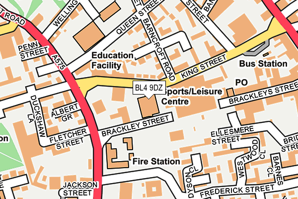
BL4 9DZ is located in the Farnworth South electoral ward, within the metropolitan district of Bolton and the English Parliamentary constituency of Bolton South East. The Sub Integrated Care Board (ICB) Location is NHS Greater Manchester ICB - 00T and the police force is Greater Manchester. This postcode has been in use since January 1980.


GetTheData
Source: OS OpenMap – Local (Ordnance Survey)
Source: OS VectorMap District (Ordnance Survey)
Licence: Open Government Licence (requires attribution)
| Easting | 373728 |
| Northing | 405740 |
| Latitude | 53.547632 |
| Longitude | -2.397970 |
GetTheData
Source: Open Postcode Geo
Licence: Open Government Licence
| Country | England |
| Postcode District | BL4 |
➜ See where BL4 is on a map ➜ Where is Farnworth? | |
GetTheData
Source: Land Registry Price Paid Data
Licence: Open Government Licence
Elevation or altitude of BL4 9DZ as distance above sea level:
| Metres | Feet | |
|---|---|---|
| Elevation | 100m | 328ft |
Elevation is measured from the approximate centre of the postcode, to the nearest point on an OS contour line from OS Terrain 50, which has contour spacing of ten vertical metres.
➜ How high above sea level am I? Find the elevation of your current position using your device's GPS.
GetTheData
Source: Open Postcode Elevation
Licence: Open Government Licence
| Ward | Farnworth South |
| Constituency | Bolton South East |
GetTheData
Source: ONS Postcode Database
Licence: Open Government Licence
| King Street/Job Centre (King Street) | Farnworth | 70m |
| King Street/Albert Road (King Street) | Farnworth | 117m |
| Albert Rd/King St (Albert Rd) | Farnworth | 123m |
| Albert Rd/King St (Albert Rd) | Farnworth | 133m |
| Albert Rd/The Royal Hotel (Albert Rd) | Farnworth | 254m |
| Farnworth Station | 0.7km |
| Moses Gate Station | 1km |
| Kearsley Station | 1.6km |
GetTheData
Source: NaPTAN
Licence: Open Government Licence
GetTheData
Source: ONS Postcode Database
Licence: Open Government Licence


➜ Get more ratings from the Food Standards Agency
GetTheData
Source: Food Standards Agency
Licence: FSA terms & conditions
| Last Collection | |||
|---|---|---|---|
| Location | Mon-Fri | Sat | Distance |
| 119 Harper Green Road | 17:40 | 12:55 | 151m |
| Farnworth Station | 18:00 | 11:05 | 201m |
| Manchester Road Kearsley | 17:30 | 11:20 | 394m |
GetTheData
Source: Dracos
Licence: Creative Commons Attribution-ShareAlike
The below table lists the International Territorial Level (ITL) codes (formerly Nomenclature of Territorial Units for Statistics (NUTS) codes) and Local Administrative Units (LAU) codes for BL4 9DZ:
| ITL 1 Code | Name |
|---|---|
| TLD | North West (England) |
| ITL 2 Code | Name |
| TLD3 | Greater Manchester |
| ITL 3 Code | Name |
| TLD36 | Greater Manchester North West |
| LAU 1 Code | Name |
| E08000001 | Bolton |
GetTheData
Source: ONS Postcode Directory
Licence: Open Government Licence
The below table lists the Census Output Area (OA), Lower Layer Super Output Area (LSOA), and Middle Layer Super Output Area (MSOA) for BL4 9DZ:
| Code | Name | |
|---|---|---|
| OA | E00024598 | |
| LSOA | E01004859 | Bolton 032B |
| MSOA | E02001015 | Bolton 032 |
GetTheData
Source: ONS Postcode Directory
Licence: Open Government Licence
| BL4 7AS | King Street | 53m |
| BL4 7AN | Barncroft Road | 103m |
| BL4 7AP | King Street | 103m |
| BL4 7AW | Princess Grove | 116m |
| BL4 9EX | Ellesmere Walk | 139m |
| BL4 7DX | Queen Street | 144m |
| BL4 7AR | Regent Walk | 145m |
| BL4 9EB | Albert Road | 160m |
| BL4 7AL | Queen Street | 174m |
| BL4 7AG | Cross Street | 174m |
GetTheData
Source: Open Postcode Geo; Land Registry Price Paid Data
Licence: Open Government Licence