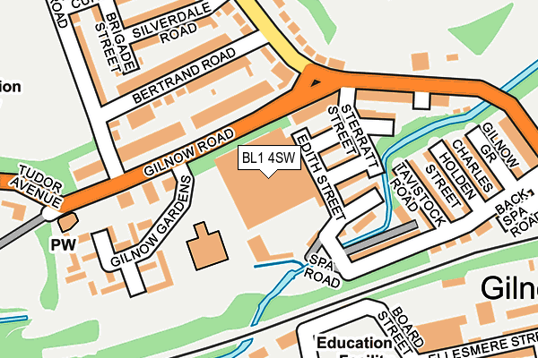
BL1 4SW is located in the Queens Park & Central electoral ward, within the metropolitan district of Bolton and the English Parliamentary constituency of Bolton North East. The Sub Integrated Care Board (ICB) Location is NHS Greater Manchester ICB - 00T and the police force is Greater Manchester. This postcode has been in use since January 1991.


GetTheData
Source: OS OpenMap – Local (Ordnance Survey)
Source: OS VectorMap District (Ordnance Survey)
Licence: Open Government Licence (requires attribution)
| Easting | 370440 |
| Northing | 408942 |
| Latitude | 53.576236 |
| Longitude | -2.447895 |
GetTheData
Source: Open Postcode Geo
Licence: Open Government Licence
| Country | England |
| Postcode District | BL1 |
➜ See where BL1 is on a map ➜ Where is Bolton? | |
GetTheData
Source: Land Registry Price Paid Data
Licence: Open Government Licence
Elevation or altitude of BL1 4SW as distance above sea level:
| Metres | Feet | |
|---|---|---|
| Elevation | 100m | 328ft |
Elevation is measured from the approximate centre of the postcode, to the nearest point on an OS contour line from OS Terrain 50, which has contour spacing of ten vertical metres.
➜ How high above sea level am I? Find the elevation of your current position using your device's GPS.
GetTheData
Source: Open Postcode Elevation
Licence: Open Government Licence
| Ward | Queens Park & Central |
| Constituency | Bolton North East |
GetTheData
Source: ONS Postcode Database
Licence: Open Government Licence
| Gilnow Road/Gilnow Gardens (Gilnow Road) | Gilnow Park | 63m |
| Gilnow Road/Park Road (Gilnow Road) | Gilnow Park | 78m |
| Gilnow Road/Heaton Cemetery (Gilnow Road) | Gilnow Park | 191m |
| Mayor Street/Spa Road (Mayor Street) | Gilnow | 287m |
| Spa Road/Mayor Street (Spa Road) | Gilnow | 343m |
| Bolton Station | 1.5km |
| Lostock Station | 3.1km |
| Hall i' th' Wood Station | 3.3km |
GetTheData
Source: NaPTAN
Licence: Open Government Licence
GetTheData
Source: ONS Postcode Database
Licence: Open Government Licence


➜ Get more ratings from the Food Standards Agency
GetTheData
Source: Food Standards Agency
Licence: FSA terms & conditions
| Last Collection | |||
|---|---|---|---|
| Location | Mon-Fri | Sat | Distance |
| Spa Road | 17:15 | 11:05 | 297m |
| 77 Tudor Avenue | 16:30 | 11:10 | 562m |
| Blackshaw Lane | 16:45 | 11:25 | 600m |
GetTheData
Source: Dracos
Licence: Creative Commons Attribution-ShareAlike
The below table lists the International Territorial Level (ITL) codes (formerly Nomenclature of Territorial Units for Statistics (NUTS) codes) and Local Administrative Units (LAU) codes for BL1 4SW:
| ITL 1 Code | Name |
|---|---|
| TLD | North West (England) |
| ITL 2 Code | Name |
| TLD3 | Greater Manchester |
| ITL 3 Code | Name |
| TLD36 | Greater Manchester North West |
| LAU 1 Code | Name |
| E08000001 | Bolton |
GetTheData
Source: ONS Postcode Directory
Licence: Open Government Licence
The below table lists the Census Output Area (OA), Lower Layer Super Output Area (LSOA), and Middle Layer Super Output Area (MSOA) for BL1 4SW:
| Code | Name | |
|---|---|---|
| OA | E00024633 | |
| LSOA | E01004871 | Bolton 015D |
| MSOA | E02000998 | Bolton 015 |
GetTheData
Source: ONS Postcode Directory
Licence: Open Government Licence
| BL1 4SA | Vincent Street | 81m |
| BL1 4SB | Bridgewater Street | 99m |
| BL1 4RZ | Ernest Street | 102m |
| BL1 4RY | Sterratt Street | 105m |
| BL1 4LH | Gilnow Road | 107m |
| BL1 4LJ | Gilnow Road | 120m |
| BL1 4LL | Gilnow Road | 136m |
| BL1 4RS | Bertrand Road | 168m |
| BL1 4RX | Park Road | 171m |
| BL1 4SG | Tavistock Road | 182m |
GetTheData
Source: Open Postcode Geo; Land Registry Price Paid Data
Licence: Open Government Licence