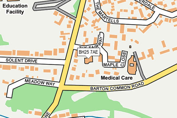
BH25 7AE lies on The Fairway in Barton On Sea, New Milton. BH25 7AE is located in the Barton & Becton electoral ward, within the local authority district of New Forest and the English Parliamentary constituency of New Forest West. The Sub Integrated Care Board (ICB) Location is NHS Hampshire and Isle of Wight ICB - D9Y0V and the police force is Hampshire. This postcode has been in use since June 2002.


GetTheData
Source: OS OpenMap – Local (Ordnance Survey)
Source: OS VectorMap District (Ordnance Survey)
Licence: Open Government Licence (requires attribution)
| Easting | 424655 |
| Northing | 93313 |
| Latitude | 50.738909 |
| Longitude | -1.651969 |
GetTheData
Source: Open Postcode Geo
Licence: Open Government Licence
| Street | The Fairway |
| Locality | Barton On Sea |
| Town/City | New Milton |
| Country | England |
| Postcode District | BH25 |
➜ See where BH25 is on a map ➜ Where is Barton on Sea? | |
GetTheData
Source: Land Registry Price Paid Data
Licence: Open Government Licence
Elevation or altitude of BH25 7AE as distance above sea level:
| Metres | Feet | |
|---|---|---|
| Elevation | 30m | 98ft |
Elevation is measured from the approximate centre of the postcode, to the nearest point on an OS contour line from OS Terrain 50, which has contour spacing of ten vertical metres.
➜ How high above sea level am I? Find the elevation of your current position using your device's GPS.
GetTheData
Source: Open Postcode Elevation
Licence: Open Government Licence
| Ward | Barton & Becton |
| Constituency | New Forest West |
GetTheData
Source: ONS Postcode Database
Licence: Open Government Licence
| The Fairway (Becton Lane) | Barton On Sea | 75m |
| The Fairway (Becton Lane) | Barton On Sea | 88m |
| Silverdale (Becton Lane) | Barton On Sea | 231m |
| Silverdale (Becton Lane) | Barton On Sea | 235m |
| Greenacre (Barton Croft) | Barton On Sea | 460m |
| New Milton Station | 1.9km |
| Hinton Admiral Station | 4.6km |
GetTheData
Source: NaPTAN
Licence: Open Government Licence
GetTheData
Source: ONS Postcode Database
Licence: Open Government Licence


➜ Get more ratings from the Food Standards Agency
GetTheData
Source: Food Standards Agency
Licence: FSA terms & conditions
| Last Collection | |||
|---|---|---|---|
| Location | Mon-Fri | Sat | Distance |
| Solent Drive | 16:00 | 11:45 | 85m |
| Greenacre | 16:00 | 11:45 | 482m |
| Grove Road | 16:00 | 11:45 | 524m |
GetTheData
Source: Dracos
Licence: Creative Commons Attribution-ShareAlike
The below table lists the International Territorial Level (ITL) codes (formerly Nomenclature of Territorial Units for Statistics (NUTS) codes) and Local Administrative Units (LAU) codes for BH25 7AE:
| ITL 1 Code | Name |
|---|---|
| TLJ | South East (England) |
| ITL 2 Code | Name |
| TLJ3 | Hampshire and Isle of Wight |
| ITL 3 Code | Name |
| TLJ36 | Central Hampshire |
| LAU 1 Code | Name |
| E07000091 | New Forest |
GetTheData
Source: ONS Postcode Directory
Licence: Open Government Licence
The below table lists the Census Output Area (OA), Lower Layer Super Output Area (LSOA), and Middle Layer Super Output Area (MSOA) for BH25 7AE:
| Code | Name | |
|---|---|---|
| OA | E00116805 | |
| LSOA | E01022987 | New Forest 022D |
| MSOA | E02004800 | New Forest 022 |
GetTheData
Source: ONS Postcode Directory
Licence: Open Government Licence
| BH25 7AD | Becton Lane | 48m |
| BH25 7AR | Maple Close | 70m |
| BH25 7AP | The Fairway | 75m |
| BH25 7AG | Becton Lane | 129m |
| BH25 7BG | The Martells | 165m |
| BH25 7AL | Becton Lane | 173m |
| BH25 5PR | Barton Common Road | 183m |
| BH25 7AW | Solent Drive | 237m |
| BH25 7TL | Willow Walk | 241m |
| BH25 7AN | Meadow Way | 266m |
GetTheData
Source: Open Postcode Geo; Land Registry Price Paid Data
Licence: Open Government Licence