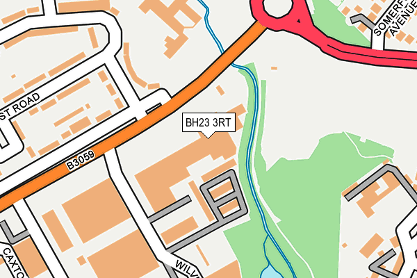
BH23 3RT is located in the Burton & Grange electoral ward, within the unitary authority of Bournemouth, Christchurch and Poole and the English Parliamentary constituency of Christchurch. The Sub Integrated Care Board (ICB) Location is NHS Dorset ICB - 11J and the police force is Dorset. This postcode has been in use since June 2016.


GetTheData
Source: OS OpenMap – Local (Ordnance Survey)
Source: OS VectorMap District (Ordnance Survey)
Licence: Open Government Licence (requires attribution)
| Easting | 418278 |
| Northing | 93528 |
| Latitude | 50.741076 |
| Longitude | -1.742328 |
GetTheData
Source: Open Postcode Geo
Licence: Open Government Licence
| Country | England |
| Postcode District | BH23 |
➜ See where BH23 is on a map ➜ Where is Christchurch? | |
GetTheData
Source: Land Registry Price Paid Data
Licence: Open Government Licence
Elevation or altitude of BH23 3RT as distance above sea level:
| Metres | Feet | |
|---|---|---|
| Elevation | 10m | 33ft |
Elevation is measured from the approximate centre of the postcode, to the nearest point on an OS contour line from OS Terrain 50, which has contour spacing of ten vertical metres.
➜ How high above sea level am I? Find the elevation of your current position using your device's GPS.
GetTheData
Source: Open Postcode Elevation
Licence: Open Government Licence
| Ward | Burton & Grange |
| Constituency | Christchurch |
GetTheData
Source: ONS Postcode Database
Licence: Open Government Licence
| Somerford Hotel (Somerford Road) | Somerford | 104m |
| Somerford Hotel (Somerford Road) | Somerford | 122m |
| Edward Road | Somerford | 128m |
| Edward Road | Somerford | 128m |
| Revvo Castor | Somerford | 270m |
| Hinton Admiral Station | 2.4km |
| Christchurch Station | 3km |
GetTheData
Source: NaPTAN
Licence: Open Government Licence
GetTheData
Source: ONS Postcode Database
Licence: Open Government Licence


➜ Get more ratings from the Food Standards Agency
GetTheData
Source: Food Standards Agency
Licence: FSA terms & conditions
| Last Collection | |||
|---|---|---|---|
| Location | Mon-Fri | Sat | Distance |
| Newlands Road | 17:45 | 13:00 | 378m |
| Highcliffe Road | 17:15 | 12:00 | 392m |
| Sainsburys | 16:30 | 12:00 | 422m |
GetTheData
Source: Dracos
Licence: Creative Commons Attribution-ShareAlike
The below table lists the International Territorial Level (ITL) codes (formerly Nomenclature of Territorial Units for Statistics (NUTS) codes) and Local Administrative Units (LAU) codes for BH23 3RT:
| ITL 1 Code | Name |
|---|---|
| TLK | South West (England) |
| ITL 2 Code | Name |
| TLK2 | Dorset and Somerset |
| ITL 3 Code | Name |
| TLK24 | Bournemouth, Christchurch and Poole |
| LAU 1 Code | Name |
| E06000058 | Bournemouth, Christchurch and Poole |
GetTheData
Source: ONS Postcode Directory
Licence: Open Government Licence
The below table lists the Census Output Area (OA), Lower Layer Super Output Area (LSOA), and Middle Layer Super Output Area (MSOA) for BH23 3RT:
| Code | Name | |
|---|---|---|
| OA | E00103096 | |
| LSOA | E01020347 | Christchurch 005B |
| MSOA | E02004240 | Christchurch 005 |
GetTheData
Source: ONS Postcode Directory
Licence: Open Government Licence
| BH23 3EJ | Edward Road | 144m |
| BH23 3QG | Somerford Road | 178m |
| BH23 3RU | Hughes Business Centre | 219m |
| BH23 3EL | Edward Road | 256m |
| BH23 3EA | Amethyst Road | 260m |
| BH23 4FF | Cherry Mews | 305m |
| BH23 3EG | Coleridge Green | 319m |
| BH23 4HZ | Highcliffe Road | 323m |
| BH23 4TU | Delta Close | 327m |
| BH23 4JA | Somerford Avenue | 352m |
GetTheData
Source: Open Postcode Geo; Land Registry Price Paid Data
Licence: Open Government Licence