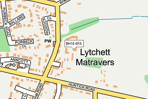
BH16 6FA is located in the Lytchett Matravers & Upton electoral ward, within the unitary authority of Dorset and the English Parliamentary constituency of Mid Dorset and North Poole. The Sub Integrated Care Board (ICB) Location is NHS Dorset ICB - 11J and the police force is Dorset. This postcode has been in use since February 2014.


GetTheData
Source: OS OpenMap – Local (Ordnance Survey)
Source: OS VectorMap District (Ordnance Survey)
Licence: Open Government Licence (requires attribution)
| Easting | 394825 |
| Northing | 95480 |
| Latitude | 50.758890 |
| Longitude | -2.074734 |
GetTheData
Source: Open Postcode Geo
Licence: Open Government Licence
| Country | England |
| Postcode District | BH16 |
➜ See where BH16 is on a map ➜ Where is Lytchett Matravers? | |
GetTheData
Source: Land Registry Price Paid Data
Licence: Open Government Licence
Elevation or altitude of BH16 6FA as distance above sea level:
| Metres | Feet | |
|---|---|---|
| Elevation | 80m | 262ft |
Elevation is measured from the approximate centre of the postcode, to the nearest point on an OS contour line from OS Terrain 50, which has contour spacing of ten vertical metres.
➜ How high above sea level am I? Find the elevation of your current position using your device's GPS.
GetTheData
Source: Open Postcode Elevation
Licence: Open Government Licence
| Ward | Lytchett Matravers & Upton |
| Constituency | Mid Dorset And North Poole |
GetTheData
Source: ONS Postcode Database
Licence: Open Government Licence
| Paddock Close (Wareham Road) | Lytchett Matravers | 137m |
| Rose And Crown | Lytchett Matravers | 202m |
| Rose And Crown (Wareham Road) | Lytchett Matravers | 229m |
| Foxhills Crescent (Foxhills Road) | Lytchett Matravers | 247m |
| Library (High Street) | Lytchett Matravers | 300m |
| Hamworthy Station | 5.4km |
GetTheData
Source: NaPTAN
Licence: Open Government Licence
GetTheData
Source: ONS Postcode Database
Licence: Open Government Licence
➜ Get more ratings from the Food Standards Agency
GetTheData
Source: Food Standards Agency
Licence: FSA terms & conditions
| Last Collection | |||
|---|---|---|---|
| Location | Mon-Fri | Sat | Distance |
| Lytchett Matravers P.o. | 16:45 | 12:30 | 244m |
| Wareham Road | 16:00 | 10:00 | 518m |
| Gables Garage | 16:30 | 10:00 | 583m |
GetTheData
Source: Dracos
Licence: Creative Commons Attribution-ShareAlike
The below table lists the International Territorial Level (ITL) codes (formerly Nomenclature of Territorial Units for Statistics (NUTS) codes) and Local Administrative Units (LAU) codes for BH16 6FA:
| ITL 1 Code | Name |
|---|---|
| TLK | South West (England) |
| ITL 2 Code | Name |
| TLK2 | Dorset and Somerset |
| ITL 3 Code | Name |
| TLK25 | Dorset |
| LAU 1 Code | Name |
| E06000059 | Dorset |
GetTheData
Source: ONS Postcode Directory
Licence: Open Government Licence
The below table lists the Census Output Area (OA), Lower Layer Super Output Area (LSOA), and Middle Layer Super Output Area (MSOA) for BH16 6FA:
| Code | Name | |
|---|---|---|
| OA | E00103777 | |
| LSOA | E01020470 | Purbeck 001C |
| MSOA | E02004263 | Purbeck 001 |
GetTheData
Source: ONS Postcode Directory
Licence: Open Government Licence
| BH16 6FH | 0m | |
| BH16 6BF | Abbotts Meadow | 100m |
| BH16 6DU | Wareham Road | 105m |
| BH16 6EA | Wareham Road | 114m |
| BH16 6AZ | Paddock Close | 153m |
| BH16 6DE | Purbeck Close | 206m |
| BH16 6BE | Foxhills Crescent | 218m |
| BH16 6BQ | High Street | 226m |
| BH16 6EW | Ballard Close | 228m |
| BH16 6EB | Huntick Estate | 238m |
GetTheData
Source: Open Postcode Geo; Land Registry Price Paid Data
Licence: Open Government Licence