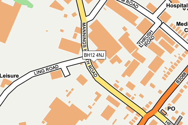
BH12 4NJ is located in the Alderney & Bourne Valley electoral ward, within the unitary authority of Bournemouth, Christchurch and Poole and the English Parliamentary constituency of Bournemouth West. The Sub Integrated Care Board (ICB) Location is NHS Dorset ICB - 11J and the police force is Dorset. This postcode has been in use since January 1980.


GetTheData
Source: OS OpenMap – Local (Ordnance Survey)
Source: OS VectorMap District (Ordnance Survey)
Licence: Open Government Licence (requires attribution)
| Easting | 403943 |
| Northing | 94201 |
| Latitude | 50.747400 |
| Longitude | -1.945477 |
GetTheData
Source: Open Postcode Geo
Licence: Open Government Licence
| Country | England |
| Postcode District | BH12 |
➜ See where BH12 is on a map ➜ Where is Poole? | |
GetTheData
Source: Land Registry Price Paid Data
Licence: Open Government Licence
Elevation or altitude of BH12 4NJ as distance above sea level:
| Metres | Feet | |
|---|---|---|
| Elevation | 60m | 197ft |
Elevation is measured from the approximate centre of the postcode, to the nearest point on an OS contour line from OS Terrain 50, which has contour spacing of ten vertical metres.
➜ How high above sea level am I? Find the elevation of your current position using your device's GPS.
GetTheData
Source: Open Postcode Elevation
Licence: Open Government Licence
| Ward | Alderney & Bourne Valley |
| Constituency | Bournemouth West |
GetTheData
Source: ONS Postcode Database
Licence: Open Government Licence
| Broom Road (Mannings Heath Road) | Alderney | 103m |
| Broom Road (Mannings Heath Road) | Alderney | 104m |
| Alderney Post Office (Mannings Heath Road) | Alderney | 152m |
| Alderney Post Office (Mannings Heath Road) | Alderney | 189m |
| Alderney Post Office (Ringwood Road) | Alderney | 247m |
| Parkstone (Dorset) Station | 2.7km |
| Branksome Station | 2.9km |
| Poole Station | 4.1km |
GetTheData
Source: NaPTAN
Licence: Open Government Licence
GetTheData
Source: ONS Postcode Database
Licence: Open Government Licence


➜ Get more ratings from the Food Standards Agency
GetTheData
Source: Food Standards Agency
Licence: FSA terms & conditions
| Last Collection | |||
|---|---|---|---|
| Location | Mon-Fri | Sat | Distance |
| Mannings Heath Road | 18:30 | 12:45 | 137m |
| Alderney P.o. | 17:30 | 12:15 | 270m |
| Ling Road | 18:30 | 12:45 | 439m |
GetTheData
Source: Dracos
Licence: Creative Commons Attribution-ShareAlike
The below table lists the International Territorial Level (ITL) codes (formerly Nomenclature of Territorial Units for Statistics (NUTS) codes) and Local Administrative Units (LAU) codes for BH12 4NJ:
| ITL 1 Code | Name |
|---|---|
| TLK | South West (England) |
| ITL 2 Code | Name |
| TLK2 | Dorset and Somerset |
| ITL 3 Code | Name |
| TLK24 | Bournemouth, Christchurch and Poole |
| LAU 1 Code | Name |
| E06000058 | Bournemouth, Christchurch and Poole |
GetTheData
Source: ONS Postcode Directory
Licence: Open Government Licence
The below table lists the Census Output Area (OA), Lower Layer Super Output Area (LSOA), and Middle Layer Super Output Area (MSOA) for BH12 4NJ:
| Code | Name | |
|---|---|---|
| OA | E00077760 | |
| LSOA | E01015380 | Poole 007A |
| MSOA | E02003200 | Poole 007 |
GetTheData
Source: ONS Postcode Directory
Licence: Open Government Licence
| BH12 4NQ | Mannings Heath Road | 119m |
| BH12 4LZ | Ringwood Road | 224m |
| BH12 4NP | Thrush Road | 238m |
| BH12 4NL | Broom Road | 253m |
| BH12 4PY | Ling Road | 292m |
| BH12 4LY | Ringwood Road | 316m |
| BH12 4LT | Ringwood Road | 317m |
| BH12 4PA | Broom Road | 320m |
| BH12 4LX | Ringwood Road | 347m |
| BH12 4NA | Ringwood Road | 356m |
GetTheData
Source: Open Postcode Geo; Land Registry Price Paid Data
Licence: Open Government Licence