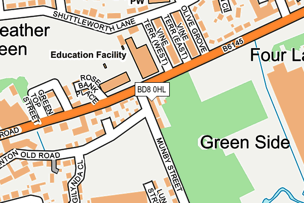
BD8 0HL lies on West View Terrace in Bradford. BD8 0HL is located in the Clayton and Fairweather Green electoral ward, within the metropolitan district of Bradford and the English Parliamentary constituency of Bradford West. The Sub Integrated Care Board (ICB) Location is NHS West Yorkshire ICB - 36J and the police force is West Yorkshire. This postcode has been in use since January 1980.


GetTheData
Source: OS OpenMap – Local (Ordnance Survey)
Source: OS VectorMap District (Ordnance Survey)
Licence: Open Government Licence (requires attribution)
| Easting | 413308 |
| Northing | 433386 |
| Latitude | 53.796614 |
| Longitude | -1.799449 |
GetTheData
Source: Open Postcode Geo
Licence: Open Government Licence
| Street | West View Terrace |
| Town/City | Bradford |
| Country | England |
| Postcode District | BD8 |
➜ See where BD8 is on a map ➜ Where is Bradford? | |
GetTheData
Source: Land Registry Price Paid Data
Licence: Open Government Licence
Elevation or altitude of BD8 0HL as distance above sea level:
| Metres | Feet | |
|---|---|---|
| Elevation | 140m | 459ft |
Elevation is measured from the approximate centre of the postcode, to the nearest point on an OS contour line from OS Terrain 50, which has contour spacing of ten vertical metres.
➜ How high above sea level am I? Find the elevation of your current position using your device's GPS.
GetTheData
Source: Open Postcode Elevation
Licence: Open Government Licence
| Ward | Clayton And Fairweather Green |
| Constituency | Bradford West |
GetTheData
Source: ONS Postcode Database
Licence: Open Government Licence
| Thornton Rd Vine Terrace West (Thornton Road) | Fairweather Green | 57m |
| Thornton Rd Munby Street (Thornton Road) | Fairweather Green | 78m |
| Thornton Rd Olive Grove (Thornton Road) | Four Lane Ends | 161m |
| Thornton Rd Jesse Street (Thornton Road) | Fairweather Green | 251m |
| Thornton Rd Lane Ends Close (Thornton Road) | Four Lane Ends | 260m |
| Bradford Forster Square Station | 3.1km |
| Frizinghall Station | 3.3km |
| Bradford Interchange Station | 3.3km |
GetTheData
Source: NaPTAN
Licence: Open Government Licence
| Percentage of properties with Next Generation Access | 100.0% |
| Percentage of properties with Superfast Broadband | 100.0% |
| Percentage of properties with Ultrafast Broadband | 100.0% |
| Percentage of properties with Full Fibre Broadband | 0.0% |
Superfast Broadband is between 30Mbps and 300Mbps
Ultrafast Broadband is > 300Mbps
| Percentage of properties unable to receive 2Mbps | 0.0% |
| Percentage of properties unable to receive 5Mbps | 0.0% |
| Percentage of properties unable to receive 10Mbps | 0.0% |
| Percentage of properties unable to receive 30Mbps | 0.0% |
GetTheData
Source: Ofcom
Licence: Ofcom Terms of Use (requires attribution)
GetTheData
Source: ONS Postcode Database
Licence: Open Government Licence


➜ Get more ratings from the Food Standards Agency
GetTheData
Source: Food Standards Agency
Licence: FSA terms & conditions
| Last Collection | |||
|---|---|---|---|
| Location | Mon-Fri | Sat | Distance |
| 90 Hunters Park Avenue Clayton | 17:30 | 12:15 | 1,338m |
| 71 Whetley Lane | 18:00 | 12:30 | 1,345m |
| Paradise Green P.o. Box | 17:00 | 11:45 | 1,363m |
GetTheData
Source: Dracos
Licence: Creative Commons Attribution-ShareAlike
The below table lists the International Territorial Level (ITL) codes (formerly Nomenclature of Territorial Units for Statistics (NUTS) codes) and Local Administrative Units (LAU) codes for BD8 0HL:
| ITL 1 Code | Name |
|---|---|
| TLE | Yorkshire and The Humber |
| ITL 2 Code | Name |
| TLE4 | West Yorkshire |
| ITL 3 Code | Name |
| TLE41 | Bradford |
| LAU 1 Code | Name |
| E08000032 | Bradford |
GetTheData
Source: ONS Postcode Directory
Licence: Open Government Licence
The below table lists the Census Output Area (OA), Lower Layer Super Output Area (LSOA), and Middle Layer Super Output Area (MSOA) for BD8 0HL:
| Code | Name | |
|---|---|---|
| OA | E00053681 | |
| LSOA | E01010628 | Bradford 040A |
| MSOA | E02002222 | Bradford 040 |
GetTheData
Source: ONS Postcode Directory
Licence: Open Government Licence
| BD8 0HP | 54m | |
| BD8 0JT | Fairweather Mews | 91m |
| BD8 0JS | Thornton Old Road | 114m |
| BD8 0LF | Vine Terrace East | 130m |
| BD8 0LB | Vine Terrace West | 131m |
| BD8 0JP | Shuttleworth Lane | 137m |
| BD8 0JW | Rose Bank Place | 152m |
| BD8 0LG | Olive Grove | 154m |
| BD8 0JN | Thornton Road | 158m |
| BD8 0LE | Thornton Road | 168m |
GetTheData
Source: Open Postcode Geo; Land Registry Price Paid Data
Licence: Open Government Licence