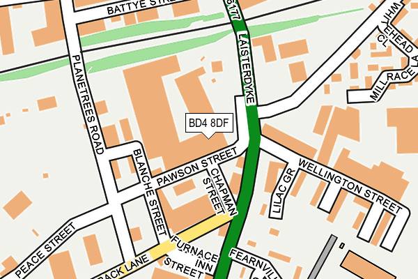
BD4 8DF is located in the Bowling and Barkerend electoral ward, within the metropolitan district of Bradford and the English Parliamentary constituency of Bradford East. The Sub Integrated Care Board (ICB) Location is NHS West Yorkshire ICB - 36J and the police force is West Yorkshire. This postcode has been in use since August 1992.


GetTheData
Source: OS OpenMap – Local (Ordnance Survey)
Source: OS VectorMap District (Ordnance Survey)
Licence: Open Government Licence (requires attribution)
| Easting | 418631 |
| Northing | 432641 |
| Latitude | 53.789756 |
| Longitude | -1.718684 |
GetTheData
Source: Open Postcode Geo
Licence: Open Government Licence
| Country | England |
| Postcode District | BD4 |
➜ See where BD4 is on a map ➜ Where is Bradford? | |
GetTheData
Source: Land Registry Price Paid Data
Licence: Open Government Licence
Elevation or altitude of BD4 8DF as distance above sea level:
| Metres | Feet | |
|---|---|---|
| Elevation | 170m | 558ft |
Elevation is measured from the approximate centre of the postcode, to the nearest point on an OS contour line from OS Terrain 50, which has contour spacing of ten vertical metres.
➜ How high above sea level am I? Find the elevation of your current position using your device's GPS.
GetTheData
Source: Open Postcode Elevation
Licence: Open Government Licence
| Ward | Bowling And Barkerend |
| Constituency | Bradford East |
GetTheData
Source: ONS Postcode Database
Licence: Open Government Licence
| New Lane (Sticker Lane) | Laisterdyke | 81m |
| Bowling Back Lane Sticker Ln (Bowling Back Lane) | Laisterdyke | 113m |
| Sticker Lane Bowling Back Ln (Sticker Lane) | Laisterdyke | 121m |
| New Lane (Laisterdyke) | Laisterdyke | 134m |
| Sticker Ln Fearnville Drive (Sticker Lane) | Laisterdyke | 164m |
| Bradford Interchange Station | 2km |
| Bradford Forster Square Station | 2.4km |
| New Pudsey Station | 3km |
GetTheData
Source: NaPTAN
Licence: Open Government Licence
GetTheData
Source: ONS Postcode Database
Licence: Open Government Licence


➜ Get more ratings from the Food Standards Agency
GetTheData
Source: Food Standards Agency
Licence: FSA terms & conditions
| Last Collection | |||
|---|---|---|---|
| Location | Mon-Fri | Sat | Distance |
| Sticker Lane P.o. Box | 17:30 | 11:45 | 222m |
| Tyersal | 17:30 | 10:45 | 545m |
| Broad Lane Business Box | 18:30 | 12:30 | 578m |
GetTheData
Source: Dracos
Licence: Creative Commons Attribution-ShareAlike
The below table lists the International Territorial Level (ITL) codes (formerly Nomenclature of Territorial Units for Statistics (NUTS) codes) and Local Administrative Units (LAU) codes for BD4 8DF:
| ITL 1 Code | Name |
|---|---|
| TLE | Yorkshire and The Humber |
| ITL 2 Code | Name |
| TLE4 | West Yorkshire |
| ITL 3 Code | Name |
| TLE41 | Bradford |
| LAU 1 Code | Name |
| E08000032 | Bradford |
GetTheData
Source: ONS Postcode Directory
Licence: Open Government Licence
The below table lists the Census Output Area (OA), Lower Layer Super Output Area (LSOA), and Middle Layer Super Output Area (MSOA) for BD4 8DF:
| Code | Name | |
|---|---|---|
| OA | E00053553 | |
| LSOA | E01010611 | Bradford 046C |
| MSOA | E02002228 | Bradford 046 |
GetTheData
Source: ONS Postcode Directory
Licence: Open Government Licence
| BD4 8DA | Blanche Street | 120m |
| BD4 8DL | Sticker Lane | 128m |
| BD4 8BY | Pawson Street | 134m |
| BD4 8DD | Planetrees Road | 140m |
| BD4 8BP | Blucher Street | 209m |
| BD4 8BE | Armstrong Street | 229m |
| BD4 8BN | Wellington Street | 233m |
| BD4 8EA | Morton Road | 234m |
| BD4 8AR | Laisterdyke | 274m |
| BD4 8BL | Dewhirst Place | 276m |
GetTheData
Source: Open Postcode Geo; Land Registry Price Paid Data
Licence: Open Government Licence