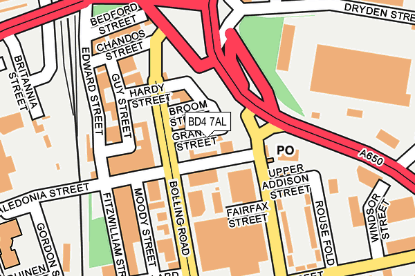
BD4 7AL is located in the Bowling and Barkerend electoral ward, within the metropolitan district of Bradford and the English Parliamentary constituency of Bradford East. The Sub Integrated Care Board (ICB) Location is NHS West Yorkshire ICB - 36J and the police force is West Yorkshire. This postcode has been in use since September 2008.


GetTheData
Source: OS OpenMap – Local (Ordnance Survey)
Source: OS VectorMap District (Ordnance Survey)
Licence: Open Government Licence (requires attribution)
| Easting | 416824 |
| Northing | 432497 |
| Latitude | 53.788523 |
| Longitude | -1.746120 |
GetTheData
Source: Open Postcode Geo
Licence: Open Government Licence
| Country | England |
| Postcode District | BD4 |
➜ See where BD4 is on a map ➜ Where is Bradford? | |
GetTheData
Source: Land Registry Price Paid Data
Licence: Open Government Licence
Elevation or altitude of BD4 7AL as distance above sea level:
| Metres | Feet | |
|---|---|---|
| Elevation | 130m | 427ft |
Elevation is measured from the approximate centre of the postcode, to the nearest point on an OS contour line from OS Terrain 50, which has contour spacing of ten vertical metres.
➜ How high above sea level am I? Find the elevation of your current position using your device's GPS.
GetTheData
Source: Open Postcode Elevation
Licence: Open Government Licence
| Ward | Bowling And Barkerend |
| Constituency | Bradford East |
GetTheData
Source: ONS Postcode Database
Licence: Open Government Licence
| Wakefield Road Hall La (Wakefield Road) | Bradford City Centre | 54m |
| Wakefield Rd Hall Lane (Wakefield Road) | Bradford City Centre | 116m |
| Bolling Road Fairfax St (Bolling Road) | Bradford City Centre | 144m |
| Wakefield Road Hall Ln (Wakefield Road) | Bradford City Centre | 171m |
| Bolling Road Fairfax St (Bolling Road) | Bradford City Centre | 184m |
| Bradford Interchange Station | 0.4km |
| Bradford Forster Square Station | 1km |
| Frizinghall Station | 3.9km |
GetTheData
Source: NaPTAN
Licence: Open Government Licence
GetTheData
Source: ONS Postcode Database
Licence: Open Government Licence


➜ Get more ratings from the Food Standards Agency
GetTheData
Source: Food Standards Agency
Licence: FSA terms & conditions
| Last Collection | |||
|---|---|---|---|
| Location | Mon-Fri | Sat | Distance |
| Wakefield Road P.o. Box | 18:30 | 11:45 | 94m |
| Mill Lane Business Box | 18:30 | 12:45 | 230m |
| Francis Street | 18:30 | 11:45 | 354m |
GetTheData
Source: Dracos
Licence: Creative Commons Attribution-ShareAlike
The below table lists the International Territorial Level (ITL) codes (formerly Nomenclature of Territorial Units for Statistics (NUTS) codes) and Local Administrative Units (LAU) codes for BD4 7AL:
| ITL 1 Code | Name |
|---|---|
| TLE | Yorkshire and The Humber |
| ITL 2 Code | Name |
| TLE4 | West Yorkshire |
| ITL 3 Code | Name |
| TLE41 | Bradford |
| LAU 1 Code | Name |
| E08000032 | Bradford |
GetTheData
Source: ONS Postcode Directory
Licence: Open Government Licence
The below table lists the Census Output Area (OA), Lower Layer Super Output Area (LSOA), and Middle Layer Super Output Area (MSOA) for BD4 7AL:
| Code | Name | |
|---|---|---|
| OA | E00054128 | |
| LSOA | E01010730 | Bradford 045C |
| MSOA | E02002227 | Bradford 045 |
GetTheData
Source: ONS Postcode Directory
Licence: Open Government Licence
| BD4 7AP | Broom Street | 38m |
| BD4 7BG | Bolling Road | 66m |
| BD4 7AD | Upper Addison Street | 121m |
| BD4 7BB | Guy Street | 147m |
| BD4 7AB | Hall Lane | 153m |
| BD4 7BA | Bolling Road | 163m |
| BD4 7AE | Rouse Fold | 198m |
| BD4 7AH | Prospect Street | 266m |
| BD4 7AQ | Windsor Street | 292m |
| BD5 0EW | Clifford Street | 294m |
GetTheData
Source: Open Postcode Geo; Land Registry Price Paid Data
Licence: Open Government Licence