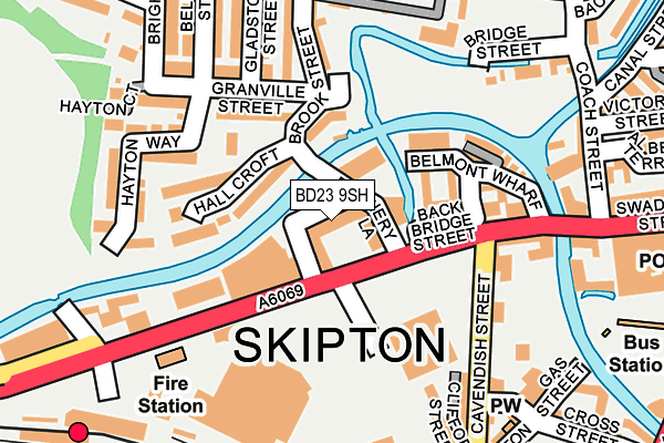
BD23 9SH is located in the Skipton West & West Craven electoral ward, within the unitary authority of North Yorkshire and the English Parliamentary constituency of Skipton and Ripon. The Sub Integrated Care Board (ICB) Location is NHS West Yorkshire ICB - 36J and the police force is North Yorkshire. This postcode has been in use since February 2005.


GetTheData
Source: OS OpenMap – Local (Ordnance Survey)
Source: OS VectorMap District (Ordnance Survey)
Licence: Open Government Licence (requires attribution)
| Easting | 398592 |
| Northing | 451564 |
| Latitude | 53.960160 |
| Longitude | -2.022947 |
GetTheData
Source: Open Postcode Geo
Licence: Open Government Licence
| Country | England |
| Postcode District | BD23 |
➜ See where BD23 is on a map ➜ Where is Skipton? | |
GetTheData
Source: Land Registry Price Paid Data
Licence: Open Government Licence
Elevation or altitude of BD23 9SH as distance above sea level:
| Metres | Feet | |
|---|---|---|
| Elevation | 100m | 328ft |
Elevation is measured from the approximate centre of the postcode, to the nearest point on an OS contour line from OS Terrain 50, which has contour spacing of ten vertical metres.
➜ How high above sea level am I? Find the elevation of your current position using your device's GPS.
GetTheData
Source: Open Postcode Elevation
Licence: Open Government Licence
| Ward | Skipton West & West Craven |
| Constituency | Skipton And Ripon |
GetTheData
Source: ONS Postcode Database
Licence: Open Government Licence
| Belle Vue Mills (Broughton Road) | Skipton | 74m |
| Belle Vue Mills (Broughton Road) | Skipton | 81m |
| Fire Station (Broughton Road) | Skipton | 167m |
| Outside Rail Station (Broughton Road) | Skipton | 219m |
| Park Avenue (Gargrave Road) | Skipton | 246m |
| Skipton Station | 0.3km |
| Cononley Station | 4.8km |
GetTheData
Source: NaPTAN
Licence: Open Government Licence
GetTheData
Source: ONS Postcode Database
Licence: Open Government Licence


➜ Get more ratings from the Food Standards Agency
GetTheData
Source: Food Standards Agency
Licence: FSA terms & conditions
| Last Collection | |||
|---|---|---|---|
| Location | Mon-Fri | Sat | Distance |
| 12 Gargrave Road | 17:30 | 12:15 | 267m |
| Skipton P.o. Box | 17:15 | 12:30 | 276m |
| Skipton Railway Station | 17:45 | 12:15 | 279m |
GetTheData
Source: Dracos
Licence: Creative Commons Attribution-ShareAlike
| Risk of BD23 9SH flooding from rivers and sea | Medium |
| ➜ BD23 9SH flood map | |
GetTheData
Source: Open Flood Risk by Postcode
Licence: Open Government Licence
The below table lists the International Territorial Level (ITL) codes (formerly Nomenclature of Territorial Units for Statistics (NUTS) codes) and Local Administrative Units (LAU) codes for BD23 9SH:
| ITL 1 Code | Name |
|---|---|
| TLE | Yorkshire and The Humber |
| ITL 2 Code | Name |
| TLE2 | North Yorkshire |
| ITL 3 Code | Name |
| TLE22 | North Yorkshire CC |
| LAU 1 Code | Name |
| E07000163 | Craven |
GetTheData
Source: ONS Postcode Directory
Licence: Open Government Licence
The below table lists the Census Output Area (OA), Lower Layer Super Output Area (LSOA), and Middle Layer Super Output Area (MSOA) for BD23 9SH:
| Code | Name | |
|---|---|---|
| OA | E00140414 | |
| LSOA | E01027581 | Craven 006C |
| MSOA | E02005747 | Craven 006 |
GetTheData
Source: ONS Postcode Directory
Licence: Open Government Licence
| BD23 1DF | Brewery Lane | 57m |
| BD23 1FL | Broughton Road | 77m |
| BD23 1RP | Belmont Street | 107m |
| BD23 1RL | Belmont Wharf | 111m |
| BD23 1PG | Hall Croft | 114m |
| BD23 1PZ | Crossley Place | 117m |
| BD23 1PR | Pine Close | 122m |
| BD23 1RU | Belle Vue Terrace | 137m |
| BD23 1RJ | Counting House Mews | 152m |
| BD23 1XB | Navigation Square | 154m |
GetTheData
Source: Open Postcode Geo; Land Registry Price Paid Data
Licence: Open Government Licence