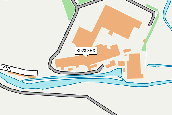
BD23 3RX is located in the Mid Craven electoral ward, within the unitary authority of North Yorkshire and the English Parliamentary constituency of Skipton and Ripon. The Sub Integrated Care Board (ICB) Location is NHS West Yorkshire ICB - 36J and the police force is North Yorkshire. This postcode has been in use since January 1980.


GetTheData
Source: OS OpenMap – Local (Ordnance Survey)
Source: OS VectorMap District (Ordnance Survey)
Licence: Open Government Licence (requires attribution)
| Easting | 393958 |
| Northing | 454035 |
| Latitude | 53.982334 |
| Longitude | -2.093622 |
GetTheData
Source: Open Postcode Geo
Licence: Open Government Licence
| Country | England |
| Postcode District | BD23 |
➜ See where BD23 is on a map ➜ Where is Gargrave? | |
GetTheData
Source: Land Registry Price Paid Data
Licence: Open Government Licence
Elevation or altitude of BD23 3RX as distance above sea level:
| Metres | Feet | |
|---|---|---|
| Elevation | 110m | 361ft |
Elevation is measured from the approximate centre of the postcode, to the nearest point on an OS contour line from OS Terrain 50, which has contour spacing of ten vertical metres.
➜ How high above sea level am I? Find the elevation of your current position using your device's GPS.
GetTheData
Source: Open Postcode Elevation
Licence: Open Government Licence
| Ward | Mid Craven |
| Constituency | Skipton And Ripon |
GetTheData
Source: ONS Postcode Database
Licence: Open Government Licence
| Johnson And Johnsons (Mill Lane) | Gargrave | 99m |
| Lyndale Garage (Skipton Road) | Gargrave | 568m |
| Lyndale Garage (Skipton Road) | Gargrave | 578m |
| Canal Bridge (A65) | Gargrave | 635m |
| Canal Bridge (A65) | Gargrave | 642m |
| Gargrave Station | 0.9km |
| Skipton Station | 5.2km |
GetTheData
Source: NaPTAN
Licence: Open Government Licence
GetTheData
Source: ONS Postcode Database
Licence: Open Government Licence


➜ Get more ratings from the Food Standards Agency
GetTheData
Source: Food Standards Agency
Licence: FSA terms & conditions
| Last Collection | |||
|---|---|---|---|
| Location | Mon-Fri | Sat | Distance |
| Gargrave P.o. Box | 17:15 | 11:45 | 695m |
| Church Street Gargrave | 17:30 | 11:30 | 825m |
| West Street Gargrave | 17:30 | 12:15 | 842m |
GetTheData
Source: Dracos
Licence: Creative Commons Attribution-ShareAlike
| Risk of BD23 3RX flooding from rivers and sea | Medium |
| ➜ BD23 3RX flood map | |
GetTheData
Source: Open Flood Risk by Postcode
Licence: Open Government Licence
The below table lists the International Territorial Level (ITL) codes (formerly Nomenclature of Territorial Units for Statistics (NUTS) codes) and Local Administrative Units (LAU) codes for BD23 3RX:
| ITL 1 Code | Name |
|---|---|
| TLE | Yorkshire and The Humber |
| ITL 2 Code | Name |
| TLE2 | North Yorkshire |
| ITL 3 Code | Name |
| TLE22 | North Yorkshire CC |
| LAU 1 Code | Name |
| E07000163 | Craven |
GetTheData
Source: ONS Postcode Directory
Licence: Open Government Licence
The below table lists the Census Output Area (OA), Lower Layer Super Output Area (LSOA), and Middle Layer Super Output Area (MSOA) for BD23 3RX:
| Code | Name | |
|---|---|---|
| OA | E00140299 | |
| LSOA | E01027563 | Craven 007C |
| MSOA | E02005748 | Craven 007 |
GetTheData
Source: ONS Postcode Directory
Licence: Open Government Licence
| BD23 3RZ | Mill Lane | 210m |
| BD23 3RU | Airebank Terrace | 246m |
| BD23 3RW | Pinfold Croft | 408m |
| BD23 3SA | Skipton Road | 450m |
| BD23 3SB | Skipton Road | 486m |
| BD23 3SD | Airedale Avenue | 505m |
| BD23 3NJ | 527m | |
| BD23 3SQ | Sharphaw View | 563m |
| BD23 3RY | River Place | 579m |
| BD23 3RS | East Street | 597m |
GetTheData
Source: Open Postcode Geo; Land Registry Price Paid Data
Licence: Open Government Licence