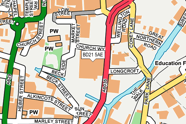
BD21 5AE is located in the Keighley Central electoral ward, within the metropolitan district of Bradford and the English Parliamentary constituency of Keighley. The Sub Integrated Care Board (ICB) Location is NHS West Yorkshire ICB - 36J and the police force is West Yorkshire. This postcode has been in use since January 1980.


GetTheData
Source: OS OpenMap – Local (Ordnance Survey)
Source: OS VectorMap District (Ordnance Survey)
Licence: Open Government Licence (requires attribution)
| Easting | 406198 |
| Northing | 440913 |
| Latitude | 53.864398 |
| Longitude | -1.907238 |
GetTheData
Source: Open Postcode Geo
Licence: Open Government Licence
| Country | England |
| Postcode District | BD21 |
➜ See where BD21 is on a map ➜ Where is Keighley? | |
GetTheData
Source: Land Registry Price Paid Data
Licence: Open Government Licence
Elevation or altitude of BD21 5AE as distance above sea level:
| Metres | Feet | |
|---|---|---|
| Elevation | 100m | 328ft |
Elevation is measured from the approximate centre of the postcode, to the nearest point on an OS contour line from OS Terrain 50, which has contour spacing of ten vertical metres.
➜ How high above sea level am I? Find the elevation of your current position using your device's GPS.
GetTheData
Source: Open Postcode Elevation
Licence: Open Government Licence
| Ward | Keighley Central |
| Constituency | Keighley |
GetTheData
Source: ONS Postcode Database
Licence: Open Government Licence
| Worth Way Hanover St (Worth Way) | Keighley | 115m |
| Cricketers Arms Ph (Coney Lane) | Keighley | 181m |
| Cricketers Arms Ph (Coney Lane) | Keighley | 182m |
| Park Ln Parkwood Street (Park Lane) | Keighley | 209m |
| Park Ln Parkwood Street (Park Lane) | Keighley | 227m |
| Ingrow West (Keighley & Worth Valley Railway) | Ingrow | 1,287m |
| Keighley Station | 0.5km |
| Crossflatts Station | 4.2km |
| Steeton & Silsden Station | 4.7km |
GetTheData
Source: NaPTAN
Licence: Open Government Licence
GetTheData
Source: ONS Postcode Database
Licence: Open Government Licence


➜ Get more ratings from the Food Standards Agency
GetTheData
Source: Food Standards Agency
Licence: FSA terms & conditions
| Last Collection | |||
|---|---|---|---|
| Location | Mon-Fri | Sat | Distance |
| 6 Hanover Street | 17:45 | 11:30 | 179m |
| Keighley Towngate Box | 17:30 | 12:30 | 314m |
| Feather Street | 17:30 | 11:15 | 389m |
GetTheData
Source: Dracos
Licence: Creative Commons Attribution-ShareAlike
The below table lists the International Territorial Level (ITL) codes (formerly Nomenclature of Territorial Units for Statistics (NUTS) codes) and Local Administrative Units (LAU) codes for BD21 5AE:
| ITL 1 Code | Name |
|---|---|
| TLE | Yorkshire and The Humber |
| ITL 2 Code | Name |
| TLE4 | West Yorkshire |
| ITL 3 Code | Name |
| TLE41 | Bradford |
| LAU 1 Code | Name |
| E08000032 | Bradford |
GetTheData
Source: ONS Postcode Directory
Licence: Open Government Licence
The below table lists the Census Output Area (OA), Lower Layer Super Output Area (LSOA), and Middle Layer Super Output Area (MSOA) for BD21 5AE:
| Code | Name | |
|---|---|---|
| OA | E00054044 | |
| LSOA | E01010710 | Bradford 008G |
| MSOA | E02002190 | Bradford 008 |
GetTheData
Source: ONS Postcode Directory
Licence: Open Government Licence
| BD21 3PT | Low Street | 146m |
| BD21 3PN | Low Street | 173m |
| BD21 3PP | Low Street | 182m |
| BD21 5JT | Alkincote Street | 201m |
| BD21 3QP | Low Street | 204m |
| BD21 5HS | Church Street | 206m |
| BD21 3PJ | Low Street | 209m |
| BD21 5HT | Church Street | 215m |
| BD21 4QX | Park Lane | 218m |
| BD21 3PX | Queensway | 222m |
GetTheData
Source: Open Postcode Geo; Land Registry Price Paid Data
Licence: Open Government Licence