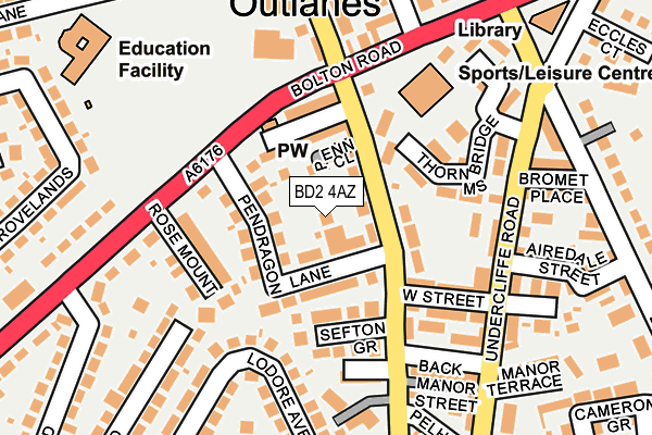
BD2 4AZ is located in the Bolton and Undercliffe electoral ward, within the metropolitan district of Bradford and the English Parliamentary constituency of Bradford East. The Sub Integrated Care Board (ICB) Location is NHS West Yorkshire ICB - 36J and the police force is West Yorkshire. This postcode has been in use since May 2017.


GetTheData
Source: OS OpenMap – Local (Ordnance Survey)
Source: OS VectorMap District (Ordnance Survey)
Licence: Open Government Licence (requires attribution)
| Easting | 417622 |
| Northing | 435488 |
| Latitude | 53.815394 |
| Longitude | -1.733842 |
GetTheData
Source: Open Postcode Geo
Licence: Open Government Licence
| Country | England |
| Postcode District | BD2 |
➜ See where BD2 is on a map ➜ Where is Bradford? | |
GetTheData
Source: Land Registry Price Paid Data
Licence: Open Government Licence
| Ward | Bolton And Undercliffe |
| Constituency | Bradford East |
GetTheData
Source: ONS Postcode Database
Licence: Open Government Licence
| Idle Rd Pen Close (Idle Road) | Bolton | 94m |
| Bolton Junction (Bolton Road) | Bolton | 110m |
| Idle Road Sefton Place (Idle Road) | Undercliffe | 157m |
| Undercliffe Rd Airedale Street (Undercliffe Road) | Bolton | 163m |
| Undercliffe Rd Airedale Street (Undercliffe Road) | Bolton | 175m |
| Frizinghall Station | 2.4km |
| Bradford Forster Square Station | 2.4km |
| Bradford Interchange Station | 2.9km |
GetTheData
Source: NaPTAN
Licence: Open Government Licence
| Percentage of properties with Next Generation Access | 100.0% |
| Percentage of properties with Superfast Broadband | 100.0% |
| Percentage of properties with Ultrafast Broadband | 0.0% |
| Percentage of properties with Full Fibre Broadband | 0.0% |
Superfast Broadband is between 30Mbps and 300Mbps
Ultrafast Broadband is > 300Mbps
| Percentage of properties unable to receive 2Mbps | 0.0% |
| Percentage of properties unable to receive 5Mbps | 0.0% |
| Percentage of properties unable to receive 10Mbps | 0.0% |
| Percentage of properties unable to receive 30Mbps | 0.0% |
GetTheData
Source: Ofcom
Licence: Ofcom Terms of Use (requires attribution)
GetTheData
Source: ONS Postcode Database
Licence: Open Government Licence


➜ Get more ratings from the Food Standards Agency
GetTheData
Source: Food Standards Agency
Licence: FSA terms & conditions
| Last Collection | |||
|---|---|---|---|
| Location | Mon-Fri | Sat | Distance |
| Bolton Junction | 17:45 | 10:45 | 140m |
| 1069 Bolton Road | 17:45 | 10:45 | 384m |
| 59 Myers Lane | 18:00 | 10:00 | 437m |
GetTheData
Source: Dracos
Licence: Creative Commons Attribution-ShareAlike
The below table lists the International Territorial Level (ITL) codes (formerly Nomenclature of Territorial Units for Statistics (NUTS) codes) and Local Administrative Units (LAU) codes for BD2 4AZ:
| ITL 1 Code | Name |
|---|---|
| TLE | Yorkshire and The Humber |
| ITL 2 Code | Name |
| TLE4 | West Yorkshire |
| ITL 3 Code | Name |
| TLE41 | Bradford |
| LAU 1 Code | Name |
| E08000032 | Bradford |
GetTheData
Source: ONS Postcode Directory
Licence: Open Government Licence
The below table lists the Census Output Area (OA), Lower Layer Super Output Area (LSOA), and Middle Layer Super Output Area (MSOA) for BD2 4AZ:
| Code | Name | |
|---|---|---|
| OA | E00053535 | |
| LSOA | E01010601 | Bradford 032A |
| MSOA | E02002214 | Bradford 032 |
GetTheData
Source: ONS Postcode Directory
Licence: Open Government Licence
| BD2 4LD | Penn Close | 50m |
| BD2 4JL | Pendragon Lane | 51m |
| BD2 4JU | Idle Road | 51m |
| BD2 4LA | Rhodes Terrace | 73m |
| BD2 4JT | Idle Road | 84m |
| BD2 4JW | Sefton Grove | 89m |
| BD2 3BQ | Charlton Close | 94m |
| BD2 4JZ | Junction Row | 101m |
| BD2 4LB | Junction Terrace | 104m |
| BD2 4JJ | Rose Mount | 114m |
GetTheData
Source: Open Postcode Geo; Land Registry Price Paid Data
Licence: Open Government Licence