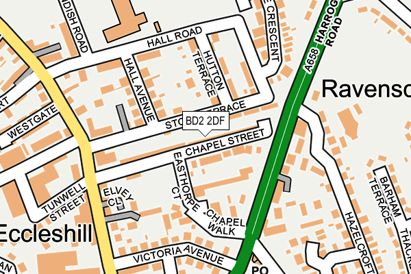
BD2 2DF is located in the Eccleshill electoral ward, within the metropolitan district of Bradford and the English Parliamentary constituency of Bradford East. The Sub Integrated Care Board (ICB) Location is NHS West Yorkshire ICB - 36J and the police force is West Yorkshire. This postcode has been in use since February 2011.


GetTheData
Source: OS OpenMap – Local (Ordnance Survey)
Source: OS VectorMap District (Ordnance Survey)
Licence: Open Government Licence (requires attribution)
| Easting | 418644 |
| Northing | 435955 |
| Latitude | 53.819541 |
| Longitude | -1.718287 |
GetTheData
Source: Open Postcode Geo
Licence: Open Government Licence
| Country | England |
| Postcode District | BD2 |
➜ See where BD2 is on a map ➜ Where is Bradford? | |
GetTheData
Source: Land Registry Price Paid Data
Licence: Open Government Licence
Elevation or altitude of BD2 2DF as distance above sea level:
| Metres | Feet | |
|---|---|---|
| Elevation | 170m | 558ft |
Elevation is measured from the approximate centre of the postcode, to the nearest point on an OS contour line from OS Terrain 50, which has contour spacing of ten vertical metres.
➜ How high above sea level am I? Find the elevation of your current position using your device's GPS.
GetTheData
Source: Open Postcode Elevation
Licence: Open Government Licence
| Ward | Eccleshill |
| Constituency | Bradford East |
GetTheData
Source: ONS Postcode Database
Licence: Open Government Licence
| Harrogate Road Hazlecroft (Harrogate Road) | Eccleshill | 107m |
| Harrogate Road Hazlecroft (Harrogate Road) | Eccleshill | 116m |
| Harrogate Rd Victoria Avenue (Harrogate Road) | Eccleshill | 172m |
| Victoria Road Chapel St (Victoria Road) | Eccleshill | 183m |
| Victoria Road Chapel St (Victoria Road) | Eccleshill | 183m |
| Apperley Bridge Station | 2.6km |
| New Pudsey Station | 3km |
| Frizinghall Station | 3.3km |
GetTheData
Source: NaPTAN
Licence: Open Government Licence
GetTheData
Source: ONS Postcode Database
Licence: Open Government Licence


➜ Get more ratings from the Food Standards Agency
GetTheData
Source: Food Standards Agency
Licence: FSA terms & conditions
| Last Collection | |||
|---|---|---|---|
| Location | Mon-Fri | Sat | Distance |
| Eccleshill | 17:15 | 11:45 | 449m |
| 62 Pullan Avenue | 18:00 | 12:15 | 516m |
| Rowanberry Close | 17:45 | 11:45 | 684m |
GetTheData
Source: Dracos
Licence: Creative Commons Attribution-ShareAlike
The below table lists the International Territorial Level (ITL) codes (formerly Nomenclature of Territorial Units for Statistics (NUTS) codes) and Local Administrative Units (LAU) codes for BD2 2DF:
| ITL 1 Code | Name |
|---|---|
| TLE | Yorkshire and The Humber |
| ITL 2 Code | Name |
| TLE4 | West Yorkshire |
| ITL 3 Code | Name |
| TLE41 | Bradford |
| LAU 1 Code | Name |
| E08000032 | Bradford |
GetTheData
Source: ONS Postcode Directory
Licence: Open Government Licence
The below table lists the Census Output Area (OA), Lower Layer Super Output Area (LSOA), and Middle Layer Super Output Area (MSOA) for BD2 2DF:
| Code | Name | |
|---|---|---|
| OA | E00053742 | |
| LSOA | E01010649 | Bradford 027A |
| MSOA | E02002209 | Bradford 027 |
GetTheData
Source: ONS Postcode Directory
Licence: Open Government Licence
| BD2 2DA | Chapel Street | 25m |
| BD2 2DX | Stott Terrace | 29m |
| BD2 2PB | Easthorpe Court | 72m |
| BD2 2DY | Hutton Terrace | 91m |
| BD2 2DT | Hall Avenue | 104m |
| BD2 2DZ | Hall Road | 118m |
| BD2 3TB | Harrogate Road | 127m |
| BD2 2EA | Chapel Walk | 128m |
| BD2 2BX | Holdsworth Square | 133m |
| BD2 2BY | Holdsworth Buildings | 141m |
GetTheData
Source: Open Postcode Geo; Land Registry Price Paid Data
Licence: Open Government Licence