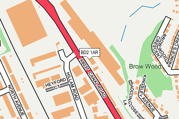
BD2 1AR lies on Canal Road in Bradford. BD2 1AR is located in the Bolton and Undercliffe electoral ward, within the metropolitan district of Bradford and the English Parliamentary constituency of Bradford East. The Sub Integrated Care Board (ICB) Location is NHS West Yorkshire ICB - 36J and the police force is West Yorkshire. This postcode has been in use since January 1980.


GetTheData
Source: OS OpenMap – Local (Ordnance Survey)
Source: OS VectorMap District (Ordnance Survey)
Licence: Open Government Licence (requires attribution)
| Easting | 415931 |
| Northing | 435193 |
| Latitude | 53.812797 |
| Longitude | -1.759539 |
GetTheData
Source: Open Postcode Geo
Licence: Open Government Licence
| Street | Canal Road |
| Town/City | Bradford |
| Country | England |
| Postcode District | BD2 |
➜ See where BD2 is on a map ➜ Where is Bradford? | |
GetTheData
Source: Land Registry Price Paid Data
Licence: Open Government Licence
Elevation or altitude of BD2 1AR as distance above sea level:
| Metres | Feet | |
|---|---|---|
| Elevation | 90m | 295ft |
Elevation is measured from the approximate centre of the postcode, to the nearest point on an OS contour line from OS Terrain 50, which has contour spacing of ten vertical metres.
➜ How high above sea level am I? Find the elevation of your current position using your device's GPS.
GetTheData
Source: Open Postcode Elevation
Licence: Open Government Licence
| Ward | Bolton And Undercliffe |
| Constituency | Bradford East |
GetTheData
Source: ONS Postcode Database
Licence: Open Government Licence
IVANHOE WORKS, 280, CANAL ROAD, BRADFORD, BD2 1AR 2011 10 OCT £45,000 |
GetTheData
Source: HM Land Registry Price Paid Data
Licence: Contains HM Land Registry data © Crown copyright and database right 2025. This data is licensed under the Open Government Licence v3.0.
| Canal Rd Midland Terrace (Canal Road) | Manningham | 43m |
| Canal Rd Midland Terrace (Canal Road) | Manningham | 65m |
| Canal Road Bolton Ln (Canel Road) | Manningham | 244m |
| Kings Rd Brow Wood Crescent (King's Road) | Bolton | 326m |
| Stanley Rd Canal Road (Stanley Road) | Bolton Woods | 350m |
| Frizinghall Station | 1km |
| Bradford Forster Square Station | 1.8km |
| Shipley Station | 2.4km |
GetTheData
Source: NaPTAN
Licence: Open Government Licence
GetTheData
Source: ONS Postcode Database
Licence: Open Government Licence


➜ Get more ratings from the Food Standards Agency
GetTheData
Source: Food Standards Agency
Licence: FSA terms & conditions
| Last Collection | |||
|---|---|---|---|
| Location | Mon-Fri | Sat | Distance |
| 2 Springwood Terrace | 17:45 | 10:00 | 527m |
| 3 Broome Avenue | 17:45 | 10:00 | 544m |
| Poplars Park Road | 17:45 | 10:00 | 804m |
GetTheData
Source: Dracos
Licence: Creative Commons Attribution-ShareAlike
| Risk of BD2 1AR flooding from rivers and sea | Low |
| ➜ BD2 1AR flood map | |
GetTheData
Source: Open Flood Risk by Postcode
Licence: Open Government Licence
The below table lists the International Territorial Level (ITL) codes (formerly Nomenclature of Territorial Units for Statistics (NUTS) codes) and Local Administrative Units (LAU) codes for BD2 1AR:
| ITL 1 Code | Name |
|---|---|
| TLE | Yorkshire and The Humber |
| ITL 2 Code | Name |
| TLE4 | West Yorkshire |
| ITL 3 Code | Name |
| TLE41 | Bradford |
| LAU 1 Code | Name |
| E08000032 | Bradford |
GetTheData
Source: ONS Postcode Directory
Licence: Open Government Licence
The below table lists the Census Output Area (OA), Lower Layer Super Output Area (LSOA), and Middle Layer Super Output Area (MSOA) for BD2 1AR:
| Code | Name | |
|---|---|---|
| OA | E00054601 | |
| LSOA | E01010824 | Bradford 034C |
| MSOA | E02002216 | Bradford 034 |
GetTheData
Source: ONS Postcode Directory
Licence: Open Government Licence
| BD2 1AP | Midland Terrace | 166m |
| BD2 1EB | Brow Wood Crescent | 243m |
| BD2 1DP | Kingsley Avenue | 258m |
| BD8 7AH | Woodview Terrace | 259m |
| BD2 1ED | Princes Crescent | 295m |
| BD2 1DW | Meadow Walk | 309m |
| BD8 7AJ | Woodview | 311m |
| BD2 1EA | Kings Road | 311m |
| BD8 7AE | Oakroyd Terrace | 313m |
| BD2 1DY | Kings Road | 324m |
GetTheData
Source: Open Postcode Geo; Land Registry Price Paid Data
Licence: Open Government Licence