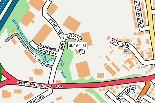
BD19 4TQ is located in the Cleckheaton electoral ward, within the metropolitan district of Kirklees and the English Parliamentary constituency of Batley and Spen. The Sub Integrated Care Board (ICB) Location is NHS West Yorkshire ICB - X2C4Y and the police force is West Yorkshire. This postcode has been in use since June 1997.


GetTheData
Source: OS OpenMap – Local (Ordnance Survey)
Source: OS VectorMap District (Ordnance Survey)
Licence: Open Government Licence (requires attribution)
| Easting | 418608 |
| Northing | 426809 |
| Latitude | 53.737339 |
| Longitude | -1.719383 |
GetTheData
Source: Open Postcode Geo
Licence: Open Government Licence
| Country | England |
| Postcode District | BD19 |
➜ See where BD19 is on a map ➜ Where is Cleckheaton? | |
GetTheData
Source: Land Registry Price Paid Data
Licence: Open Government Licence
Elevation or altitude of BD19 4TQ as distance above sea level:
| Metres | Feet | |
|---|---|---|
| Elevation | 90m | 295ft |
Elevation is measured from the approximate centre of the postcode, to the nearest point on an OS contour line from OS Terrain 50, which has contour spacing of ten vertical metres.
➜ How high above sea level am I? Find the elevation of your current position using your device's GPS.
GetTheData
Source: Open Postcode Elevation
Licence: Open Government Licence
| Ward | Cleckheaton |
| Constituency | Batley And Spen |
GetTheData
Source: ONS Postcode Database
Licence: Open Government Licence
| Hunsworth Lane Links Ave (Hunsworth Lane) | Hunsworth | 295m |
| Hunsworth Lane Greenroyd Ave (Hunsworth Lane) | Hunsworth | 303m |
| Hunsworth Lane Links Ave (Hunsworth Lane) | Hunsworth | 307m |
| Hunsworth Lane Greenroyd Ave (Hunsworth Lane) | Hunsworth | 316m |
| Hunsworth Lane Mill Ln (Hunsworth Lane) | Hunsworth | 347m |
| Low Moor Station | 2.6km |
| Brighouse Station | 5.9km |
GetTheData
Source: NaPTAN
Licence: Open Government Licence
GetTheData
Source: ONS Postcode Database
Licence: Open Government Licence


➜ Get more ratings from the Food Standards Agency
GetTheData
Source: Food Standards Agency
Licence: FSA terms & conditions
| Last Collection | |||
|---|---|---|---|
| Location | Mon-Fri | Sat | Distance |
| 75 Hunsworth Lane | 17:45 | 12:45 | 298m |
| Hunsworth Village | 17:45 | 12:45 | 378m |
| Moorend | 17:30 | 12:30 | 802m |
GetTheData
Source: Dracos
Licence: Creative Commons Attribution-ShareAlike
The below table lists the International Territorial Level (ITL) codes (formerly Nomenclature of Territorial Units for Statistics (NUTS) codes) and Local Administrative Units (LAU) codes for BD19 4TQ:
| ITL 1 Code | Name |
|---|---|
| TLE | Yorkshire and The Humber |
| ITL 2 Code | Name |
| TLE4 | West Yorkshire |
| ITL 3 Code | Name |
| TLE44 | Calderdale and Kirklees |
| LAU 1 Code | Name |
| E08000034 | Kirklees |
GetTheData
Source: ONS Postcode Directory
Licence: Open Government Licence
The below table lists the Census Output Area (OA), Lower Layer Super Output Area (LSOA), and Middle Layer Super Output Area (MSOA) for BD19 4TQ:
| Code | Name | |
|---|---|---|
| OA | E00055735 | |
| LSOA | E01011068 | Kirklees 003C |
| MSOA | E02002273 | Kirklees 003 |
GetTheData
Source: ONS Postcode Directory
Licence: Open Government Licence
| BD19 4EQ | Oak Rise | 204m |
| BD19 4DB | Marsland Court | 228m |
| BD19 4DS | Westroyd Avenue | 267m |
| BD19 3QB | Centurion Way | 277m |
| BD19 4DP | Hunsworth Lane | 282m |
| BD19 4DR | Hunsworth Lane | 289m |
| BD19 4EF | Hunsworth Lane | 328m |
| BD19 4DY | Greenroyd Avenue | 351m |
| BD19 4EG | Links Avenue | 372m |
| BD19 4DX | Hunsworth Lane | 384m |
GetTheData
Source: Open Postcode Geo; Land Registry Price Paid Data
Licence: Open Government Licence