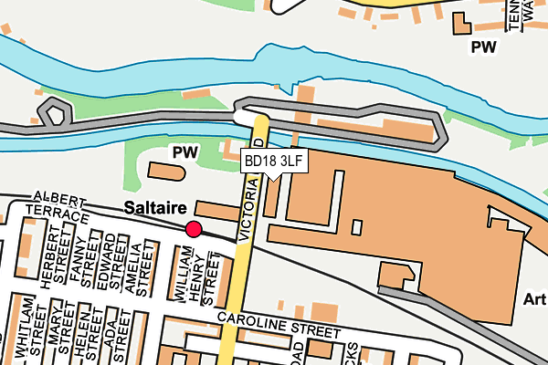
BD18 3LF is located in the Shipley electoral ward, within the metropolitan district of Bradford and the English Parliamentary constituency of Shipley. The Sub Integrated Care Board (ICB) Location is NHS West Yorkshire ICB - 36J and the police force is West Yorkshire. This postcode has been in use since December 2000.


GetTheData
Source: OS OpenMap – Local (Ordnance Survey)
Source: OS VectorMap District (Ordnance Survey)
Licence: Open Government Licence (requires attribution)
| Easting | 413977 |
| Northing | 438095 |
| Latitude | 53.838920 |
| Longitude | -1.789080 |
GetTheData
Source: Open Postcode Geo
Licence: Open Government Licence
| Country | England |
| Postcode District | BD18 |
➜ See where BD18 is on a map ➜ Where is Shipley? | |
GetTheData
Source: Land Registry Price Paid Data
Licence: Open Government Licence
Elevation or altitude of BD18 3LF as distance above sea level:
| Metres | Feet | |
|---|---|---|
| Elevation | 70m | 230ft |
Elevation is measured from the approximate centre of the postcode, to the nearest point on an OS contour line from OS Terrain 50, which has contour spacing of ten vertical metres.
➜ How high above sea level am I? Find the elevation of your current position using your device's GPS.
GetTheData
Source: Open Postcode Elevation
Licence: Open Government Licence
| Ward | Shipley |
| Constituency | Shipley |
GetTheData
Source: ONS Postcode Database
Licence: Open Government Licence
| Caroline Street Exhibition Rd (Caroline Street) | Saltaire | 149m |
| Caroline Street Exhibition Rd (Caroline Street) | Saltaire | 177m |
| Caroline Street Edward St (Caroline Street) | Saltaire | 216m |
| Coach Rd Aire View Cres (Coach Road) | Baildon | 218m |
| Caroline Street Edward St (Caroline Street) | Saltaire | 223m |
| Saltaire Station | 0.1km |
| Shipley Station | 1.2km |
| Frizinghall Station | 2.5km |
GetTheData
Source: NaPTAN
Licence: Open Government Licence
GetTheData
Source: ONS Postcode Database
Licence: Open Government Licence


➜ Get more ratings from the Food Standards Agency
GetTheData
Source: Food Standards Agency
Licence: FSA terms & conditions
| Last Collection | |||
|---|---|---|---|
| Location | Mon-Fri | Sat | Distance |
| Victoria Road Saltaire | 17:30 | 12:15 | 249m |
| Albert Road | 17:45 | 12:30 | 280m |
| Saltaire Road | 17:45 | 12:15 | 415m |
GetTheData
Source: Dracos
Licence: Creative Commons Attribution-ShareAlike
The below table lists the International Territorial Level (ITL) codes (formerly Nomenclature of Territorial Units for Statistics (NUTS) codes) and Local Administrative Units (LAU) codes for BD18 3LF:
| ITL 1 Code | Name |
|---|---|
| TLE | Yorkshire and The Humber |
| ITL 2 Code | Name |
| TLE4 | West Yorkshire |
| ITL 3 Code | Name |
| TLE41 | Bradford |
| LAU 1 Code | Name |
| E08000032 | Bradford |
GetTheData
Source: ONS Postcode Directory
Licence: Open Government Licence
The below table lists the Census Output Area (OA), Lower Layer Super Output Area (LSOA), and Middle Layer Super Output Area (MSOA) for BD18 3LF:
| Code | Name | |
|---|---|---|
| OA | E00054389 | |
| LSOA | E01033694 | Bradford 020F |
| MSOA | E02002202 | Bradford 020 |
GetTheData
Source: ONS Postcode Directory
Licence: Open Government Licence
| BD18 4PR | Albert Terrace | 101m |
| BD18 3LA | Victoria Road | 112m |
| BD18 4PS | Albert Terrace | 125m |
| BD18 3LX | Victoria Road | 128m |
| BD18 3LZ | Victoria Road | 128m |
| BD18 4PP | William Henry Street | 137m |
| BD18 4PT | George Street | 148m |
| BD18 4PW | Caroline Street | 163m |
| BD18 3JZ | Caroline Street | 165m |
| BD18 4PX | Amelia Street | 170m |
GetTheData
Source: Open Postcode Geo; Land Registry Price Paid Data
Licence: Open Government Licence