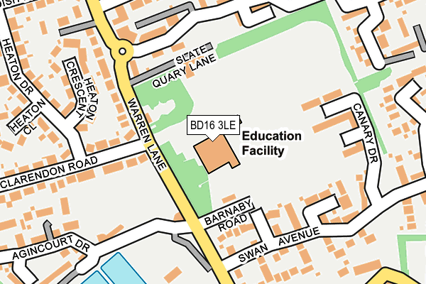
BD16 3LE is located in the Bingley electoral ward, within the metropolitan district of Bradford and the English Parliamentary constituency of Shipley. The Sub Integrated Care Board (ICB) Location is NHS West Yorkshire ICB - 36J and the police force is West Yorkshire. This postcode has been in use since January 1980.


GetTheData
Source: OS OpenMap – Local (Ordnance Survey)
Source: OS VectorMap District (Ordnance Survey)
Licence: Open Government Licence (requires attribution)
| Easting | 412036 |
| Northing | 439636 |
| Latitude | 53.852834 |
| Longitude | -1.818519 |
GetTheData
Source: Open Postcode Geo
Licence: Open Government Licence
| Country | England |
| Postcode District | BD16 |
➜ See where BD16 is on a map ➜ Where is Bingley? | |
GetTheData
Source: Land Registry Price Paid Data
Licence: Open Government Licence
Elevation or altitude of BD16 3LE as distance above sea level:
| Metres | Feet | |
|---|---|---|
| Elevation | 170m | 558ft |
Elevation is measured from the approximate centre of the postcode, to the nearest point on an OS contour line from OS Terrain 50, which has contour spacing of ten vertical metres.
➜ How high above sea level am I? Find the elevation of your current position using your device's GPS.
GetTheData
Source: Open Postcode Elevation
Licence: Open Government Licence
| Ward | Bingley |
| Constituency | Shipley |
GetTheData
Source: ONS Postcode Database
Licence: Open Government Licence
| Eldwick Primary School (Warren Lane) | Gilstead | 75m |
| Eldwick Primary School (Warren Lane) | Gilstead | 88m |
| Warren Lane Swan Ave (Warren Lane) | Gilstead | 180m |
| Warren Lane Swan Ave (Warren Lane) | Gilstead | 216m |
| Warren Ln Warren Drive (Warren Lane) | Eldwick | 363m |
| Bingley Station | 1.3km |
| Crossflatts Station | 1.8km |
| Saltaire Station | 2.4km |
GetTheData
Source: NaPTAN
Licence: Open Government Licence
GetTheData
Source: ONS Postcode Database
Licence: Open Government Licence


➜ Get more ratings from the Food Standards Agency
GetTheData
Source: Food Standards Agency
Licence: FSA terms & conditions
| Last Collection | |||
|---|---|---|---|
| Location | Mon-Fri | Sat | Distance |
| Clarendon | 17:00 | 12:30 | 95m |
| Warren Lane | 17:00 | 12:30 | 307m |
| Gilstead P.o. Box | 17:15 | 12:15 | 525m |
GetTheData
Source: Dracos
Licence: Creative Commons Attribution-ShareAlike
The below table lists the International Territorial Level (ITL) codes (formerly Nomenclature of Territorial Units for Statistics (NUTS) codes) and Local Administrative Units (LAU) codes for BD16 3LE:
| ITL 1 Code | Name |
|---|---|
| TLE | Yorkshire and The Humber |
| ITL 2 Code | Name |
| TLE4 | West Yorkshire |
| ITL 3 Code | Name |
| TLE41 | Bradford |
| LAU 1 Code | Name |
| E08000032 | Bradford |
GetTheData
Source: ONS Postcode Directory
Licence: Open Government Licence
The below table lists the Census Output Area (OA), Lower Layer Super Output Area (LSOA), and Middle Layer Super Output Area (MSOA) for BD16 3LE:
| Code | Name | |
|---|---|---|
| OA | E00176212 | |
| LSOA | E01010580 | Bradford 010B |
| MSOA | E02002192 | Bradford 010 |
GetTheData
Source: ONS Postcode Directory
Licence: Open Government Licence
| BD16 3BP | Warren Lane | 102m |
| BD16 3PN | Slate Quarry Lane | 117m |
| BD16 3DJ | Clarendon Road | 138m |
| BD16 3PX | Bluebird Walk | 149m |
| BD16 3BR | Warren Lane | 153m |
| BD16 3PY | Canary Drive | 175m |
| BD16 3BS | Warren Lane | 183m |
| BD16 3PU | Swan Avenue | 191m |
| BD16 3DP | Heaton Crescent | 206m |
| BD16 3PF | Timble Drive | 224m |
GetTheData
Source: Open Postcode Geo; Land Registry Price Paid Data
Licence: Open Government Licence